„Yakima Fold Belt“ – Versionsunterschied
| [ungesichtete Version] | [ungesichtete Version] |
Bri (Diskussion | Beiträge) K →Sources: add authorlink (Pogue) |
Bri (Diskussion | Beiträge) →Further reading: add Blakely 2011 |
||
| Zeile 58: | Zeile 58: | ||
*{{citation|title=Geology of the Yakima Valley wine country — a geologic field trip guide from Stevenson to Zillah, Washington|first1=David K.|last1=Norman|first2=Alan J. |last2=Busacca|first3=Ron |last3=Teissere|publisher=[[Washington State Department of Natural Resources]] Division of Geology and Earth Resources|date=June 2004|url=http://www.dnr.wa.gov/publications/ger_ftg1_yakima_valley_wine_country.pdf}} |
*{{citation|title=Geology of the Yakima Valley wine country — a geologic field trip guide from Stevenson to Zillah, Washington|first1=David K.|last1=Norman|first2=Alan J. |last2=Busacca|first3=Ron |last3=Teissere|publisher=[[Washington State Department of Natural Resources]] Division of Geology and Earth Resources|date=June 2004|url=http://www.dnr.wa.gov/publications/ger_ftg1_yakima_valley_wine_country.pdf}} |
||
*{{citation|work=Digital Atlas of Idaho: Digital Geology of Idaho|title=Columbia River Basalt Province Unit |date=c. April 2007|first1=Kristen |last1=Straub |first2=Paul |last2=Link|publisher=Idaho State University, Dept. of Geosciences|url=http://geology.isu.edu/Digital_Geology_Idaho/Module10/mod10.htm}}<!-- date estimated from Wayback Machine--> — includes flythrough animations |
*{{citation|work=Digital Atlas of Idaho: Digital Geology of Idaho|title=Columbia River Basalt Province Unit |date=c. April 2007|first1=Kristen |last1=Straub |first2=Paul |last2=Link|publisher=Idaho State University, Dept. of Geosciences|url=http://geology.isu.edu/Digital_Geology_Idaho/Module10/mod10.htm}}<!-- date estimated from Wayback Machine--> — includes flythrough animations |
||
*{{citation|title=Connecting the Yakima fold and thrust belt to active faults in the Puget Lowland, Washington|authors=Blakely et al.|journal=Journal of Geophysical Research: Solid Earth|volume=116|issue=B7|date=July 28, 2011|doi=10.1029/2010JB008091}} |
|||
{{Washington State hills and ridges}} |
{{Washington State hills and ridges}} |
||
Version vom 29. August 2014, 01:48 Uhr
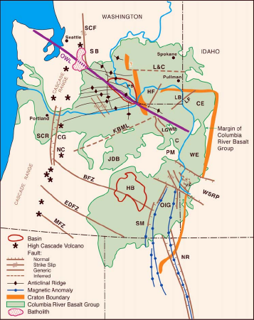
Vorlage:Infobox mountain range The Yakima Fold Belt, also called the Yakima fold-and-thrust belt, is a Vorlage:Convert structural-tectonic sub province of the western Columbia Plateau Province, developed since c. 10.5 Ma.Vorlage:SfnVorlage:SfnVorlage:Sfn
Geology

It is the central portion of the Olympic-Wallowa Lineament, referred to as the Cle Elum-Wallula deformed zone (CLEW),Vorlage:Sfn consising of a series of generally east-trending narrow asymmetrical anticlinal ridges and broad synclinal valleys formed by folding of Miocene Columbia River basalt flows and sediments.Vorlage:SfnVorlage:Sfn In most parts of the belt the folds have a north vergence (Columbia Hills' south vergence is an exception) with the steep limb typically faulted by imbricate thrust faults.Vorlage:SfnVorlage:Sfn Fold lengths range from 1 km to 100 km with wavelengths from several kilometers to 20 km.Vorlage:Sfn
A graben underlies nearly the entire Yakima Fold Belt and has been subsiding since Eocene time, and continues to sink at a slow rate.Vorlage:Sfn
Location
The northern boundary is the Ice Harbor dike in the Saddle Mountains;Vorlage:Sfn the southern boundary is the Blue Mountains of Oregon-Washington.Vorlage:Sfn Hills and ridges included in the fold belt include Badger Mountain and Beezley Hills;Vorlage:Sfn Mosier Syncline and The Dalles Syncline;Vorlage:Sfn Red Mountain, Snipes Mountain, and Wahluke Slope;Vorlage:Sfn Columbia Hills, Frenchman Hills, Saddle Mountains, Umtanum Ridge, Yakima Ridge, Rattlesnake Hills, and Horse Heaven Hills.Vorlage:Sfn
Geodesy
Geodetic studies of the Oregon Rotation show that Oregon is rotating about a point somewhat south of Lewiston, Idaho compressing the Yakima fold an average of 3 millimeters per year, and the Washington Pacific coast about 7 millimeters per year.Vorlage:Sfn
Studies of the motion of the Yakima Fold Belt have been undertaken to evaluate seismic hazards at the Hanford Site.Vorlage:Sfn
See also
Notes and sources
Notes
Sources
- Vorlage:Citation
- Vorlage:Citation
- Vorlage:Citation
- Vorlage:Citation
- Vorlage:Citation
- Vorlage:Citation
- Vorlage:Citation
- Vorlage:Citation
Further reading
- Vorlage:Citation
- Vorlage:Cite thesis
- Vorlage:Citation
- Vorlage:Citation — includes flythrough animations
- Vorlage:Citation