Datei:110th US Congress House districts color.svg
Zur Navigation springen
Zur Suche springen

Größe der PNG-Vorschau dieser SVG-Datei: 800 × 482 Pixel. Weitere aus SVG automatisch erzeugte PNG-Grafiken in verschiedenen Auflösungen: 320 × 193 Pixel | 640 × 386 Pixel | 1.024 × 617 Pixel | 1.280 × 772 Pixel | 2.560 × 1.543 Pixel | 2.583 × 1.557 Pixel
Originaldatei (SVG-Datei, Basisgröße: 2.583 × 1.557 Pixel, Dateigröße: 1,24 MB)
![]()
Diese Datei und die Informationen unter dem roten Trennstrich werden aus dem zentralen Medienarchiv Wikimedia Commons eingebunden.
![]()
Beschreibung
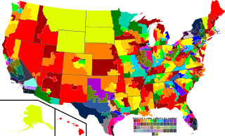
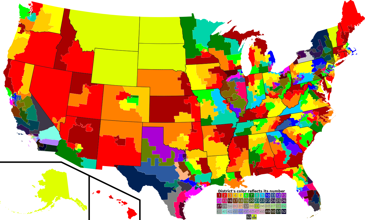
| Beschreibung | A map of all of the U.S. congressional districts (as of the 110th Congress). To find the district's number, look at the district, compare with the color code at the bottom to get number. |
| Datum | |
| Quelle | Based off of: [1] for most boundaries, [2] for Georgia, and [3] for Texas. |
| Urheber | Mr. Matté (if there is an issue with this image, contact me using this image's Commons talk page, my Commons user talk page, or my English Wikipedia user talk page; I'll know about it a lot faster) |
| Andere Versionen |
Abgeleitete Werke dieser Datei: 113th US Congress House districts color.svg Image:US Congressional districts metro areas.svg (Same as this, but includes large views for urban areas) |
| SVG‑Erstellung |
![[1]](https://upload.wikimedia.org/wikipedia/commons/archive/2/22/20061111221306%21US_House_Winning_Margins.png)
Legend of map colors:
1st District
|
2nd District
|
3rd District
|
4th District
|
5th District
|
6th District
|
7th District
|
8th District
|
9th District
|
10th District
|
11th District
|
12th District
|
13th District
|
14th District
|
15th District
|
16th District
|
17th District
|
18th District
|
19th District
|
20th District
|
21st District
|
22nd District
|
23rd District
|
24th District
|
25th District
|
26th District
|
27th District
|
28th District
|
29th District
|
30th District
|
31st District
|
32nd District
|
33rd District
|
34th District
|
35th District
|
36th District
|
37th District
|
38th District
|
39th District
|
40th District
|
41st District
|
42nd District
|
43rd District
|
44th District
|
45th District
|
46th District
|
47th District
|
48th District
|
49th District
|
50th District
|
51st District
|
52nd District
|
53rd District
|
At-large District
|
Lizenz
| Ich, der Urheberrechtsinhaber dieses Werkes, veröffentliche es als gemeinfrei. Dies gilt weltweit. In manchen Staaten könnte dies rechtlich nicht möglich sein. Sofern dies der Fall ist: Ich gewähre jedem das bedingungslose Recht, dieses Werk für jedweden Zweck zu nutzen, es sei denn, Bedingungen sind gesetzlich erforderlich. |
Dateiversionen
Klicke auf einen Zeitpunkt, um diese Version zu laden.
| Version vom | Vorschaubild | Maße | Benutzer | Kommentar | |
|---|---|---|---|---|---|
| aktuell | 00:28, 15. Sep. 2009 | | 2.583 × 1.557 (1,24 MB) | Mr. Matté | Fix western CA districts |
| 17:45, 17. Jul. 2009 |  | 2.583 × 1.557 (1,22 MB) | Mr. Matté | Fix NY 26/27, make one path --> text | |
| 04:52, 21. Aug. 2008 |  | 2.583 × 1.557 (1,25 MB) | Mr. Matté | Fix Hawaii | |
| 04:38, 16. Apr. 2008 |  | 2.583 × 1.557 (1,3 MB) | Mr. Matté | Higher-quality, smaller version of the colored congressional map by district number | |
| 01:06, 7. Feb. 2008 |  | 9.111 × 5.493 (1,87 MB) | Mr. Matté | {{Information |Description=A map of all of the U.S. congressional districts (as of the 110th Congress). To find the district's number, look at the district, compar |
Dateiverwendung
Keine Seiten verwenden diese Datei.
Globale Dateiverwendung
Die nachfolgenden anderen Wikis verwenden diese Datei:
- Verwendung auf ca.wikipedia.org
- Verwendung auf es.wikipedia.org