Datei:Districts of the Bono East Region (2019).png
Zur Navigation springen
Zur Suche springen

Größe dieser Vorschau: 800 × 556 Pixel. Weitere Auflösungen: 320 × 222 Pixel | 640 × 445 Pixel | 1.024 × 711 Pixel | 1.438 × 999 Pixel
Originaldatei (1.438 × 999 Pixel, Dateigröße: 363 KB, MIME-Typ: image/png)
![]()
Diese Datei und die Informationen unter dem roten Trennstrich werden aus dem zentralen Medienarchiv Wikimedia Commons eingebunden.
![]()
.png?uselang=de)
Beschreibung
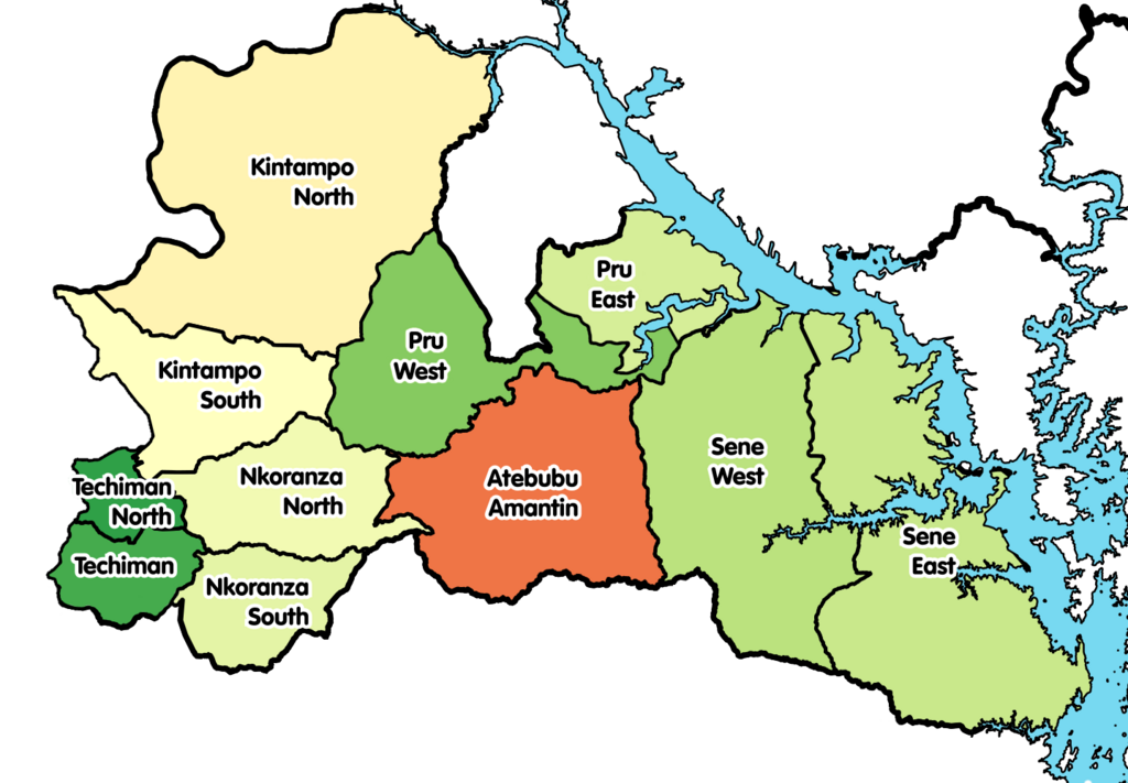
| Beschreibung | Map showing the districts of the Bono East Region of Ghana in 2019. |
| Datum | |
| Quelle | Eigenes Werk |
| Urheber |
|
Lizenz
Ich, der Urheber dieses Werkes, veröffentliche es unter der folgenden Lizenz:
Diese Datei ist lizenziert unter der Creative-Commons-Lizenz „Namensnennung – Weitergabe unter gleichen Bedingungen 4.0 international“.
- Dieses Werk darf von dir
- verbreitet werden – vervielfältigt, verbreitet und öffentlich zugänglich gemacht werden
- neu zusammengestellt werden – abgewandelt und bearbeitet werden
- Zu den folgenden Bedingungen:
- Namensnennung – Du musst angemessene Urheber- und Rechteangaben machen, einen Link zur Lizenz beifügen und angeben, ob Änderungen vorgenommen wurden. Diese Angaben dürfen in jeder angemessenen Art und Weise gemacht werden, allerdings nicht so, dass der Eindruck entsteht, der Lizenzgeber unterstütze gerade dich oder deine Nutzung besonders.
- Weitergabe unter gleichen Bedingungen – Wenn du das Material wiedermischst, transformierst oder darauf aufbaust, musst du deine Beiträge unter der gleichen oder einer kompatiblen Lizenz wie das Original verbreiten.
Dateiversionen
Klicke auf einen Zeitpunkt, um diese Version zu laden.
| Version vom | Vorschaubild | Maße | Benutzer | Kommentar | |
|---|---|---|---|---|---|
| aktuell | 20:06, 19. Mär. 2021 | | 1.438 × 999 (363 KB) | Jakob Gottfried | {{Information |Description=Map showing the districts of the Bono East Region of Ghana in 2019. |Source={{own}} |Date=2021-03-16 |Author= *Derivative work: User:Jakob Gottfried *Original work: User:Macabe5387 |Permission= |other_versions= }} Category:Maps of the Bono East Region |
Dateiverwendung
Die folgende Seite verwendet diese Datei:
Globale Dateiverwendung
Die nachfolgenden anderen Wikis verwenden diese Datei:
- Verwendung auf ceb.wikipedia.org
- Verwendung auf dga.wikipedia.org
- Verwendung auf en.wikipedia.org
- Verwendung auf es.wikipedia.org
- Verwendung auf gpe.wikipedia.org
- Verwendung auf incubator.wikimedia.org
- Verwendung auf it.wikipedia.org
- Verwendung auf pl.wikipedia.org
- Verwendung auf www.wikidata.org
- Verwendung auf yo.wikipedia.org
- Verwendung auf zu.wikipedia.org
.png)