Datei:Earthquake wave paths.png

Earthquake_wave_paths.png (300 × 250 Pixel, Dateigröße: 13 KB, MIME-Typ: image/png)
![]()
Diese Datei und die Informationen unter dem roten Trennstrich werden aus dem zentralen Medienarchiv Wikimedia Commons eingebunden.
![]()

|
File:Earthquake wave paths.svg ist eine vektorisierte Version dieses Bildes. Diese sollte an Stelle des Rasterbildes verwendet werden, sofern sie nicht schlechter ist.
File:Earthquake wave paths.png → File:Earthquake wave paths.svg
Für weitere Informationen siehe Help:SVG. |
 |
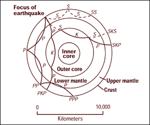
Cross section of the whole Earth, showing the complexity of paths of earthquake waves. The paths curve because the different rock types found at different depths change the speed at which the waves travel. Solid lines marked P are compressional waves; dashed lines marked S are shear waves. S waves do not travel through the core but may be converted to compressional waves (marked K) on entering the core (PKP, SKS). Waves may be reflected at the surface (PP, PPP, SS).
Seismographs detect the various types of waves. Analysis of such records reveals structures within the Earth.
Source: http://pubs.usgs.gov/gip/interior/fig2.gif ; original upload in english wikipedia, 15 April 2005 by SEWilco
Dieses Bild ist gemeinfrei (public domain), weil es Materialien beeinhaltet, die ursprünglich vom United States Geological Survey, einer Behörde des Innenministeriums der Vereinigten Staaten, stammen. Weitere Informationen finden Sie in den Urheberrechtsbestimmungen des USGS
|
Ursprüngliches Datei-Logbuch
| Version vom | Maße | Benutzer | Kommentar |
|---|---|---|---|
| 4. September 2005, 12:53:16 | 300 × 250 (13208 bytes) | Saperaud (Diskussion · Beiträge) | Cross section of the whole [[Earth]], showing the complexity of paths of [[earthquake]] waves. The paths curve because the different rock types found at different depths change the speed at which the waves travel. Solid lines marked P are compressional wa |
Dateiversionen
Klicke auf einen Zeitpunkt, um diese Version zu laden.
| Version vom | Vorschaubild | Maße | Benutzer | Kommentar | |
|---|---|---|---|---|---|
| aktuell | 18:54, 6. Jan. 2015 | | 300 × 250 (13 KB) | GifTagger | Bot: Converting file to superior PNG file. (Source: Earthquake_wave_paths.gif). This GIF was problematic due to non-greyscale color table. |
Dateiverwendung
Die folgende Seite verwendet diese Datei:
Globale Dateiverwendung
Die nachfolgenden anderen Wikis verwenden diese Datei:
- Verwendung auf ary.wikipedia.org
- Verwendung auf cs.wikipedia.org
- Verwendung auf en.wikipedia.org
- Verwendung auf es.wikipedia.org
- Verwendung auf fi.wikipedia.org
- Verwendung auf fr.wikipedia.org
- Verwendung auf it.wikipedia.org
- Verwendung auf nds.wikipedia.org
- Verwendung auf sk.wikipedia.org
- Verwendung auf tr.wikipedia.org
- Verwendung auf vi.wikipedia.org
- Verwendung auf zh-yue.wikipedia.org
- Verwendung auf zh.wikipedia.org