Datei:LongitudinalProfileGotthardtbahnAndTunnelSwitzerland.jpg

Originaldatei (1.732 × 1.138 Pixel, Dateigröße: 242 KB, MIME-Typ: image/jpeg)
![]()
Diese Datei und die Informationen unter dem roten Trennstrich werden aus dem zentralen Medienarchiv Wikimedia Commons eingebunden.
![]()
Beschreibung
| Beschreibung |
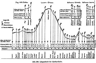
English: Longitudinal profile of the Gotthardbahn from Luzern to Chiasso in Switzerland. The route elevation above sea level in [m] is shown above the travel distance from Luzern in [km] as linear interpolation between stations. Positions of stations, water stations, tunnels galleries and national borders are marked. The elevation of stations in [m] and steepest in- and decline of segments between stations are noted in [‰]. Branchlines from Zug to Arth-Goldau, from Bellinzona to Dirinella and from Bellinzona to Locarno are also shown. |
||||
| Datum | 1914, book (or prior source predating the publication of volume 5 of Röll's encyclopedia in 1914) | ||||
| Quelle | Gotthardbahn in: Röll, V. Freiherr von: Enzyklopädie des Eisenbahnwesens, Band 5. Berlin, Wien 1914, S. 354-361. digitized version on www.zeno.org/Roell-1912 | ||||
| Urheber | Dietler, Hermann (1839-10-01 - 1924-01-24); Röll, Victor Freiherr von (1852-05-22 - 1922-10-12) | ||||
| Genehmigung (Weiternutzung dieser Datei) |
|
||||
The original German caption of the graph in the cited publication was "Abb.288. Längenschnitt der Gotthardbahn". The elevation of the apex of the Gotthard tunnel at 1151 m is not noted in the graph.
The legend on the left side of the graph translates as follows:
Legend
Stations
Watterstations
Tunnels and Galleries
Station elevation
above sealevel: Meter
Steepest Decline ‰
Steepest Incline ‰
Links to the station locations itemized in the graph (links to German Wikipedia article if no English one existed):
Branchline Zug to Arth-Goldau: Zug , Walchwil, Arth-Goldau
Main Gotthard Line:
Luzern, Meggen, Küssnacht, Immensee,
Arth-Goldau, Steinen, Schwyz, Brunnen, Sisikon, Flüelen, Altdorf, Erstfeld, Amsteg, Gurtnellen, Wassen, Göschenen,
Gotthard Tunnel, Airolo, Ambri-Piotta, Ambri-Piotta, Rodi-Fiesso, Faido, Lavorgo, Giornico, Bodio, Biasca, Osogna, Claro, Castione, Bellinzona, Giubiasco, Rivera-Bironico, Taverne, Lugano, Melide,
Maroggia, Capolago, Mendrisio, Balerna, Chiasso
Branchline Bellinzona to Locarno: Bellinzona, Giubiasco, Cadenazzo, Gordola, Locarno
Branchline Bellinzona to Darinella: Bellinzona, Giubiasco, Cadenazzo, Magadino, St. Nazzaro, Ronzo-Gera, Dirinella
A map of the Gotthardbahn from the same article shows its route and connection to the northern and southern European networks.
The graph was probably drawn by a professional draftsman by hand, following the guidelines of an engineer and using already accumulated, corrected and tabulated data. There were probably many predecessors to this drawing and the underlying table produced at various stages of the long construction period of ten years, not taking into account prior planning and surveying time. The draftman would lay out the paper on the drawing table, aligning it with respect to the table's etches and fixing its position with thumb nails. He would develop the drawing with pencil starting with a horizontal baseline over the whole width of the sheet for angular and height reference. If possible he will place the baseline such that he can use it for the drawing and does not have to removed it later. From here he constructs the drawing with pencil and rulers typically from left to right, first doing the outline, leaving sufficient space for labeling and legend. Having based his design on the most recent earlier version he probably will not have to revise and can continue first with ruler later doing the fine details by hand. For higher contrast he will then trail the pencil lines with Indian ink using a dip pen with metal tip also rough from rough to fine detail. After drying he will add pencil ledger lines and add the intended labeling in ink by hand. Having finished the drawing he last draws an appropriate frame around the graph pulls the thumbnails and cuts the drawing to size removing the holes left by the nails.
Some of the station names are red or can be red slightly different from their current names today: St. Nazzaro / San Nazarro Ronzo-Gera / (Ronco de Martignoni-) Gerra Arth-Goldou / Arth Goldau Wossen / Wassen Ambri-Riotta / Ambri-Piotta Rodi-hesso / Rodi-Fiesso Larargo / Lavago
These deviations can be the result of the manual drawing process used, just a mispelling, the change of a living language over 100 years, the international work team using different languages leading to confusion, the villages or towns having different names in the different Swiss national languages. In the above links to the locations of the stations I always choose the current spelling with the exception of Ronzo-Gera, where I kept the spelling from the graph.
The author of the article Dietler did not provide a copyright for the graphs used nor did he use specific citations within his article and listed sources as "literature" solely at the end of his chapter. It is not clear if he is the original author of any of the illustrations or whether he copied them from one of the books or periodicals listed or from elsewhere. Disregarding the listed business reports of the Gotthardbahn and its liquidation commission the most recent dated literature listed originates from 1895. Obviously all listed sources predate the publication of volume 5 of Röll's encyclopedia in 1914. Dietler lists the sources as follows below. Originals of the graph might be found there. With standard operation of the Gotthardbahn having started on 1 June 1882 the line was well established during the publication of volume 5 of Röll's encyclopedia in 1915. The engineering drawings probably dates from somewhere between the final planning period and the time just before the last construction phase.
Literatur of the article:
- – Die Gotthardbahn in kommerzieller Beziehung. Zürich 1864.
- – Begründung von Distanztabellen, graph. Darstellung der Verkehrsgebiete. Basel 1864.
- – Die Gotthardbahn in technischer Beziehung, enthaltend die technischen Gutachten von Beckh und Gerwig, Dezember 1864, und von Wetli, Januar 1865, sowie eine Rentabilitätsberechnung von Koller, Schmidlin u. Stoll, März 1865. Zürich.
- – Koller, Schmidlin und Stoll, Die Gotthardbahn und ihre Konkurrenten. Zürich, August 1865.
- – Koller, Schmidlin und Stoll, Die Gotthardbahn und der Luckmanier. Zürich, Oktober 1865.
- – Les projets de chemins de fer par les alpes helvétiques. Zürich 1869.
- – Conférences internationales pour la construction du chemin de fer par le St. Gotthard, tenues à Berne, Procès-Verbal des Séances, 15 Septembre – 13 Octobre 1869.
- – Hellwag, Die Bahnachse und das Längenprofil der Gotthardbahn nebst approximativem Kostenvoranschlag und die Ursachen der Überschreitung des Voranschlags der tessinischen Bahnen, Zürich, 3. und 6. Februar 1876.
- – Expertise concernant le chemin de fer du St. Gothard, Commission Plénèire et Sous-Commission, Procès-Verbal des Séances, 31 Juliett – 22 Novembre 1876. Bern.
- – Conférences internationales pour la construction du chemin de fer par le St. Gothard tenues à Lucerne, Procès-Verbal des Séances, 4–13 Juin 1877.
- – Erster bis achtunddreißigster Geschäftsbericht der Direktion und des Verwaltungsrates der Gotthardbahn über den Zeitraum vom 6. Dezember 1871 bis 30. April 1909; drei Geschäftsberichte der Liquidationskommission über den Zeitraum vom 1. Mai 1909 bis 30. Juni 1912.
- – Rapports mensuels et trimestriels du Conseil federal suisse sur l'état des travaux de la ligne du St. Gothard.
- – Wanner, Geschichte der Begründung des Gotthardbahnunternehmens. Luzern 1880.
- – Dolezalek, Die Gotthardbahn. Hann. Ztschr. 1882.
- – Wanner, Rückblick auf die Entstehung und den Bau der Gotthardbahn. Luzern 1882.
- – Wanner, Geschichte des Baffes der Gotthardbahn. Luzern 1885.
- – Stapff, Geologische Übersichtskarte der Gotthardbahnstrecke Erstfeld-Castione, 10 Blätter 1 : 25.000. Berlin 1885.
- – Mémoire du Département Fédéral Suisse des chemins de fer sur la construction du chemin de fer du St. Gothard. Bern 1888.
- – Rich. Bechtle, Die Gotthardbahn. Stuttgart 1895.
Lizenz
|
Dieses Werk ist gemeinfrei, weil seine urheberrechtliche Schutzfrist abgelaufen ist. | |
| Es wurde festgestellt, dass diese Datei frei von bekannten Beschränkungen durch das Urheberrecht ist, alle verbundenen und verwandten Rechte eingeschlossen. | |
Dateiversionen
Klicke auf einen Zeitpunkt, um diese Version zu laden.
| Version vom | Vorschaubild | Maße | Benutzer | Kommentar | |
|---|---|---|---|---|---|
| aktuell | 01:49, 16. Aug. 2009 | | 1.732 × 1.138 (242 KB) | PasoAPaso | {{Information |Description={{en|1=Longitudinal profile of the Gotthardbahn from Luzern to Chiasso in Switzerland. The route elevation above sea level in [m] is shown above the travel distance from Luzern in [km] as linear interpolation between stations. P |
Dateiverwendung
Die folgenden 2 Seiten verwenden diese Datei:
Globale Dateiverwendung
Die nachfolgenden anderen Wikis verwenden diese Datei:
- Verwendung auf cs.wikipedia.org
- Verwendung auf en.wikipedia.org
- Verwendung auf eo.wikipedia.org
- Verwendung auf it.wikipedia.org
- Verwendung auf pt.wikipedia.org
- Verwendung auf sl.wikipedia.org
- Verwendung auf www.wikidata.org