Datei:Milpitas view2.JPG

Originaldatei (2.104 × 1.580 Pixel, Dateigröße: 872 KB, MIME-Typ: image/jpeg)
![]()
Diese Datei und die Informationen unter dem roten Trennstrich werden aus dem zentralen Medienarchiv Wikimedia Commons eingebunden.
![]()
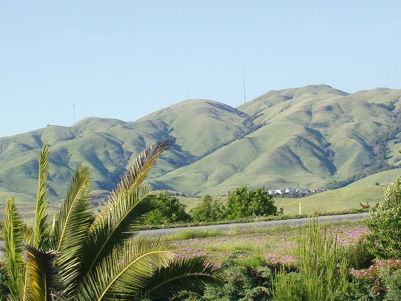
Looking east toward Monument Peak in Milpitas, California. The rightmost (tallest) antenna is Monument Peak, while the leftmost one (second highest, with three "forks" visible) is Mount Allison. The small antenna in the center was recently built. The gully to the far right of the mountainside is Calera Creek. Just to its left is Scott Creek. Most of the area can be accessed via hking trails in Ed R. Levin County Park.
Going right - south. Going left is north. Mount Allison is about a mile north of Monument Peak.
The actual point of Monument Peak is the point lying directly right (south) of the tallest antenna (FCC structure 1019291).
Notice Mount Allison's antenna - it has three "forks" on the top.
Can you see a few hiking trails leading up to Monument Peak?
The houses at the bottom of the mountains are the upper-class Calaveras Ridge Estates on Calaveras Ridge Road.
The hills are golden because of the dry summer season which dehydrates the grass on the hillsides. The hills are considered a high-risk fire hazard region.
| Dieses Werk wurde von seinem Urheber Milpitas guy in der Wikipedia auf Englisch als gemeinfrei veröffentlicht. Dies gilt weltweit. In manchen Staaten könnte dies rechtlich nicht möglich sein. Sofern dies der Fall ist: Milpitas guy gewährt jedem das bedingungslose Recht, dieses Werk für jedweden Zweck zu nutzen, es sei denn, Bedingungen sind gesetzlich erforderlich. |
.JPG)
Dateiversionen
Klicke auf einen Zeitpunkt, um diese Version zu laden.
| Version vom | Vorschaubild | Maße | Benutzer | Kommentar | |
|---|---|---|---|---|---|
| aktuell | 17:33, 22. Dez. 2006 | | 2.104 × 1.580 (872 KB) | Nk | Looking east toward Monument Peak in Milpitas, California. The rightmost (tallest) antenna is Monument Peak, while the leftmost one (second highest, with three "forks" visible) is Mount Allison. The small antenna in the center was recently built. The gull |
Dateiverwendung
Die folgende Seite verwendet diese Datei:
Globale Dateiverwendung
Die nachfolgenden anderen Wikis verwenden diese Datei:
- Verwendung auf arz.wikipedia.org
- Verwendung auf ceb.wikipedia.org
- Verwendung auf en.wikipedia.org
- Verwendung auf eo.wikipedia.org
- Verwendung auf es.wikipedia.org
- Verwendung auf fr.wikipedia.org
- Verwendung auf he.wikipedia.org
- Verwendung auf ja.wikipedia.org
- Verwendung auf lld.wikipedia.org
- Verwendung auf pam.wikipedia.org
- Verwendung auf uz.wikipedia.org
- Verwendung auf www.wikidata.org