Datei:Mount Mazama eruption timeline.PNG
Originaldatei (250 × 841 Pixel, Dateigröße: 187 KB, MIME-Typ: image/png)
![]()
Diese Datei und die Informationen unter dem roten Trennstrich werden aus dem zentralen Medienarchiv Wikimedia Commons eingebunden.
![]()
Beschreibung
| Beschreibung |
|
| Quelle | http://pubs.usgs.gov/fs/2002/fs092-02/ (saved as PNG) |
| Urheber | U.S. GEOLOGICAL SURVEY and the NATIONAL PARK SERVICE |
| Andere Versionen |
    |

|
Dieses Bild des Typs Geology sollte als Vektorgrafik im SVG-Format neu erstellt werden. Vektorformate haben zahlreiche Vorteile; weitere Information unter Commons:Media for cleanup. Wenn dir eine SVG-Version dieses Bildes vorliegt, so lade diese bitte hoch. Nach dem Hochladen der Datei ist diese Vorlage auf der aktuellen Bildbeschreibungsseite durch die Vorlage {{Vector version available}}, oder kürzer {{Vva}}, zu ersetzen. Es ist empfohlen die neue SVG-Datei „Mount Mazama eruption timeline.svg“ zu nennen – dann benötigt die Vorlage vector version available (bzw. vva) keinen Parameter.
|
Lizenz
Dieses Bild ist gemeinfrei (public domain), weil es Materialien beeinhaltet, die ursprünglich vom United States Geological Survey, einer Behörde des Innenministeriums der Vereinigten Staaten, stammen. Weitere Informationen finden Sie in den Urheberrechtsbestimmungen des USGS
|
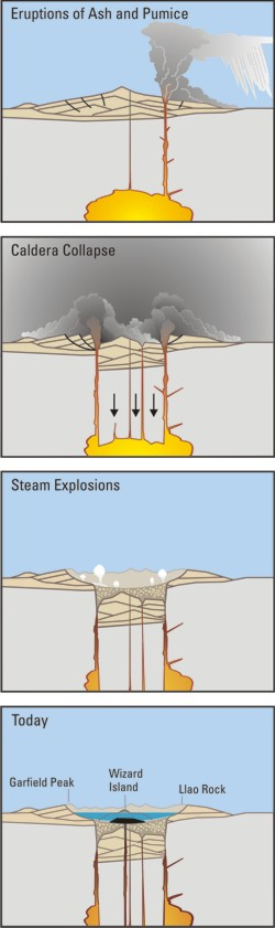
Crater Lake is an example, it is located in Oregen and was made from a valcano, making a caldera.
Dateiversionen
Klicke auf einen Zeitpunkt, um diese Version zu laden.
| Version vom | Vorschaubild | Maße | Benutzer | Kommentar | |
|---|---|---|---|---|---|
| aktuell | 07:24, 29. Mär. 2006 | 250 × 841 (187 KB) | Jkelly | Source: http://pubs.usgs.gov/fs/2002/fs092-02/ (saved as PNG) Author: U.S. GEOLOGICAL SURVEY and the NATIONAL PARK SERVICE Description: <blockquote>Cataclysmic eruption to present. Eruptions of ash and pumice: The cataclysmic eruption started from a ve |
Dateiverwendung
Die folgende Seite verwendet diese Datei:
Globale Dateiverwendung
Die nachfolgenden anderen Wikis verwenden diese Datei:
- Verwendung auf af.wikipedia.org
- Verwendung auf an.wikipedia.org
- Verwendung auf ar.wikipedia.org
- Verwendung auf ast.wikipedia.org
- Verwendung auf br.wikipedia.org
- Verwendung auf ce.wikipedia.org
- Verwendung auf cy.wikipedia.org
- Verwendung auf en.wikipedia.org
- Verwendung auf en.wikiversity.org
- Verwendung auf eo.wikipedia.org
- Verwendung auf es.wikipedia.org
- Verwendung auf fa.wikipedia.org
- Verwendung auf fi.wikipedia.org
- Verwendung auf fr.wikipedia.org
- Verwendung auf id.wikipedia.org
- Verwendung auf it.wikipedia.org
- Verwendung auf ja.wikipedia.org
- Verwendung auf ko.wikipedia.org
- Verwendung auf lv.wikipedia.org
- Verwendung auf min.wikipedia.org
- Verwendung auf mk.wikipedia.org
- Verwendung auf ml.wikipedia.org
- Verwendung auf pt.wikipedia.org
- Verwendung auf ru.wikipedia.org
- Verwendung auf simple.wikipedia.org
- Verwendung auf sk.wikipedia.org
- Verwendung auf sr.wikipedia.org
- Verwendung auf su.wikipedia.org
- Verwendung auf vi.wikipedia.org
- Verwendung auf www.wikidata.org