Category:Altes Landhaus Innsbruck
Jump to navigation
Jump to search
| Object location | | View all coordinates using: OpenStreetMap |
|---|
building in Innsbruck, Austria  | |||||
| Upload media | |||||
| Instance of |
| ||||
|---|---|---|---|---|---|
| Location | Innsbruck, Tyrol, Austria | ||||
| Street address |
| ||||
| Architectural style | |||||
| Architect | |||||
| Heritage designation | |||||
 | |||||
| This category shows the protected monument with the number 64257 in Austria. (Commons, de, Wikidata) |
|
This category shows the remarkable cultural object in the Austrian state of Tyrol listed by the Tyrolean Art Cadastre with the ID
83612. (on tirisMaps, pdf, more images on Commons, Wikidata) |
Subcategories
This category has the following 3 subcategories, out of 3 total.
H
L
- Landhauskapelle (Innsbruck) (13 F)
Media in category "Altes Landhaus Innsbruck"
The following 26 files are in this category, out of 26 total.
-
 2700 - Innsbruck - Altes Landhaus.JPG 3,648 × 2,736; 2.72 MB
-
 2715 - Innsbruck - Altes Landhaus.JPG 2,736 × 3,648; 2.38 MB
-
 Altes Landhaus, Innsbruck 2.jpg 2,632 × 3,059; 3.85 MB
-
 Altes Landhaus, Innsbruck 3.jpg 2,494 × 3,896; 4.82 MB
-
 Altes Landhaus, Innsbruck.jpg 2,473 × 3,917; 4.78 MB
-
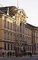
 Austria-01428 - Old Federal State Parliament (21402523873).jpg 6,000 × 4,000; 20.25 MB
-
 Gedenktafel Altes Landhaus Franz Mair.jpg 4,022 × 3,016; 2.77 MB
-
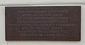 Gedenktafel Franz Mair Landhaus.jpg 4,281 × 2,267; 2.45 MB
-
 IA FuggerTaxis AltesLandhaus A.jpg 1,224 × 930; 366 KB
-
 Innsbruck (11).jpg 4,528 × 3,344; 1.5 MB
-
 Innsbruck - Altes Landhaus (Tiroler Landtag)1 (cropped).jpg 4,404 × 2,297; 4.49 MB
-
 Innsbruck - Altes Landhaus (Tiroler Landtag)1.jpg 4,404 × 2,985; 5.47 MB
-
 Innsbruck - Altes Landhaus (Tiroler Landtag)2.jpg 3,702 × 3,111; 5.25 MB
-
 Innsbruck-60-Landhaus-2006-gje.jpg 2,048 × 2,580; 1.64 MB
-
 Innsbruck-Landhaus-Rokokosaal.jpg 3,264 × 2,448; 1.99 MB
-
 InnsbruckStadt2.JPG 2,346 × 1,601; 1,012 KB
-
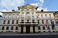
 Landhaus Innsbruck (front).jpg 2,048 × 1,536; 769 KB
-
 Landhaus mit Landhauskapelle hl. Georg.jpg 2,048 × 1,360; 547 KB
-
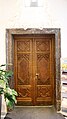 Landhaus-Landtagssaal-Türe-03.JPG 2,576 × 4,592; 1.2 MB
-
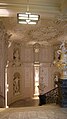 Landhaus-Stiegenhaus-02.jpg 2,576 × 4,592; 1.03 MB
-
 Maria-Theresien-Straße 43 (IMG 1723).jpg 4,697 × 3,131; 4.61 MB
-
 Maria-Theresien-Straße 43 (IMG 1724).jpg 2,859 × 5,082; 4.42 MB
-
 Maria-Theresien-Straße 43 (IMG 1727).jpg 2,763 × 4,420; 3.69 MB
-
 Maria-Theresien-Straße 43 45 (IMG 1715).jpg 4,537 × 3,025; 4.16 MB
-
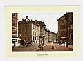
 Plan der kk Privinzial-Hauptstadt Innsbruck (Staendehaus und Post).png 690 × 510; 1.01 MB
-
 Widerstandstafel.jpg 6,000 × 4,000; 14.24 MB


.jpg)


.jpg)
1_(cropped).jpg)
1.jpg)
2.jpg)


.jpg)


.jpg)
.jpg)
.jpg)
.jpg)
.png)
