Category:Brücke Franz-Josef-Straße, Langenlois
Jump to navigation
Jump to search
| Object location | | View all coordinates using: OpenStreetMap |
|---|
 | |||||
| Upload media | |||||
| Instance of | |||||
|---|---|---|---|---|---|
| Location | Langenlois, Krems District, Lower Austria, Austria | ||||
| Street address |
| ||||
| Heritage designation | |||||
 | |||||
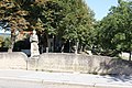
Deutsch: Straßenbrücke mit Figurenbildstock hl. Johannes Nepomuk, Langenlois
Media in category "Brücke Franz-Josef-Straße, Langenlois"
The following 3 files are in this category, out of 3 total.
-
 Bruecke franz josef platz.JPG 5,184 × 3,456; 11.47 MB
-
 Statue hl Johannes Nepomuk 01 Loisbachbrücke 2015-08.jpg 3,200 × 4,800; 5.75 MB
-
 Statue hl Johannes Nepomuk 02 Loisbachbrücke 2015-08.jpg 3,200 × 4,800; 4.98 MB

