Category:Burgruine Rundersburg
Jump to navigation
Jump to search
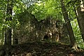
| This category shows the protected monument with the number 90711 in Austria. (Commons, de, Wikidata) |
| Object location | | View all coordinates using: OpenStreetMap |
|---|
rocca  | |||||
| Upload media | |||||
| Instance of |
| ||||
|---|---|---|---|---|---|
| Location | Sankt Leonhard am Hornerwald, Krems District, Lower Austria, Austria | ||||
| Heritage designation | |||||
 | |||||
Media in category "Burgruine Rundersburg"
The following 9 files are in this category, out of 9 total.
-
 Burgruine Rundersburg - Innenhof 2.jpg 3,900 × 2,600; 5.12 MB
-
 Burgruine Rundersburg - Innenhof 3.jpg 3,900 × 2,600; 4.91 MB
-
 Burgruine Rundersburg - Innenhof.jpg 3,900 × 2,600; 5.16 MB
-
 Burgruine Rundersburg - Mauerreste an der Ostseite.jpg 3,900 × 2,600; 4.63 MB
-
 Burgruine Rundersburg - Südostansicht.jpg 3,900 × 2,600; 5.01 MB
-
 Burgruine Rundersburg - Südseite 2.jpg 3,900 × 2,600; 4.03 MB
-
 Burgruine Rundersburg - Südseite.jpg 3,900 × 2,600; 4.94 MB
-
 Burgruine Rundersburg - Westliche Mauer.jpg 3,900 × 2,600; 4.48 MB
-
 Rundersburg Winter 2020 2021.jpg 2,560 × 1,920; 1.78 MB


