Category:Kaiserjägerdenkmal, Fluherstraße (Bregenz)
Jump to navigation
Jump to search
| Object location | | View all coordinates using: OpenStreetMap |
|---|
 | |||||
| Upload media | |||||
| Instance of | |||||
|---|---|---|---|---|---|
| Location | Bregenz, Bregenz District, Vorarlberg, Austria | ||||
| Street address |
| ||||
| Heritage designation | |||||
 | |||||
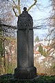
Deutsch: Kaiserjägerdenkmal und Kriegerdenkmal (1939 -1945) an der Fluherstraße beim ehem. Gallusstift in Bregenz (Vorarlberg, Austria).
Media in category "Kaiserjägerdenkmal, Fluherstraße (Bregenz)"
The following 4 files are in this category, out of 4 total.
-
 Kaiserjägerdenkmal, Fluherstraße Bregenz 1.JPG 4,103 × 2,725; 3.99 MB
-
 Kaiserjägerdenkmal, Fluherstraße Bregenz 2.JPG 2,829 × 4,261; 8.4 MB
-
 Kaiserjägerdenkmal, Fluherstraße Bregenz 3.JPG 3,198 × 2,399; 1.98 MB
-
 Kaiserjägerdenkmal, Fluherstraße Bregenz 4.JPG 2,848 × 4,288; 8.52 MB


