Category:Kapelle am Kobel
Jump to navigation
Jump to search
| Object location | | View all coordinates using: OpenStreetMap |
|---|
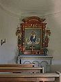
| This category shows the protected monument with the number 65726 in Austria. (Commons, de, Wikidata) |
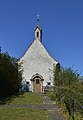
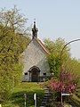
building in Götzis, Austria  | |||||
| Upload media | |||||
| Instance of | |||||
|---|---|---|---|---|---|
| Patron saint | |||||
| Location | Götzis, Feldkirch District, Vorarlberg, Austria | ||||
| Street address |
| ||||
| Heritage designation | |||||
 | |||||
Media in category "Kapelle am Kobel"
The following 6 files are in this category, out of 6 total.
-
 Goetzis-Tankstelle Kobel-Kapelle Kobel-01.jpg 7,197 × 5,456; 4.18 MB
-
 Götzis im Hag 2, Kapelle am Kobel 1.JPG 3,283 × 4,742; 9.32 MB
-
 Götzis im Hag 2, Kapelle am Kobel 2.JPG 2,580 × 3,440; 4.49 MB
-
 Götzis im Hag 2, Kapelle am Kobel 3.JPG 3,608 × 2,706; 4.61 MB
-
 Kapelle am Kobel in Götzis.JPG 1,954 × 2,605; 3.98 MB
-
 Kapelle und Gasthaus Kobel.jpg 1,923 × 1,434; 321 KB


