Category:Leeberg Pettendorf
Jump to navigation
Jump to search
| Object location | | View all coordinates using: OpenStreetMap |
|---|
 | |||||
| Upload media | |||||
| Instance of | |||||
|---|---|---|---|---|---|
| Location | Hausleiten, Korneuburg District, Lower Austria, Austria | ||||
| Street address |
| ||||
| Heritage designation | |||||
 | |||||
Deutsch: Denkmalgeschützter Tumulus in Pettendorf, eine Ortschaft in der niederösterreichischen Gemeinde Hausleiten.
Media in category "Leeberg Pettendorf"
The following 8 files are in this category, out of 8 total.
-
 Leeberg 2010 4.jpg 3,296 × 2,472; 1.02 MB
-
 Panoramafernrohr am Leeberg.jpg 1,772 × 1,236; 416 KB
-
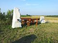 Rastplatz am Leeberg.jpg 1,024 × 768; 531 KB
-
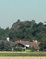 Tumulus in Pettendorf von Gaisruck aus gesehen.jpg 713 × 902; 735 KB
-
 Tumulus von Pettendorf Neugestaltung 2014.JPG 3,216 × 2,136; 1.71 MB
-
 Tumulus, Trockenrasen und Lösswand bei Gaisruck sl1.jpg 4,128 × 3,096; 8.76 MB
-
 Tumulus, Trockenrasen und Lösswand bei Gaisruck sl11.jpg 3,096 × 4,128; 3.95 MB
-
 Tumulus, Trockenrasen und Lösswand bei Gaisruck sl2.jpg 4,128 × 3,096; 7.19 MB


