Category:Lutherstiege, Knittelfeld
Jump to navigation
Jump to search
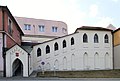
Deutsch: Lutherstiege Knittelfeld
| This category shows the protected monument with the number 75857 in Austria. (Commons, de, Wikidata) |
| Object location | | View all coordinates using: OpenStreetMap |
|---|
 | |||||
| Upload media | |||||
| Instance of | |||||
|---|---|---|---|---|---|
| Location | Knittelfeld, Murtal District, Styria, Austria | ||||
| Street address |
| ||||
| Heritage designation | |||||
 | |||||
Media in category "Lutherstiege, Knittelfeld"
The following 3 files are in this category, out of 3 total.
-
 Knittelfeld Lutherstiege.jpg 1,024 × 691; 93 KB
-
 Lutherstiege Innen1.jpg 3,632 × 5,456; 15.64 MB
-
 Lutherstiege Innen2.jpg 5,161 × 7,226; 52.84 MB

