Category:Pestkreuz, Maria Saal
Jump to navigation
Jump to search
| This category shows the protected monument with the number 12911 in Austria. (Commons, de, Wikidata) |
| Object location | | View all coordinates using: OpenStreetMap |
|---|
 | |||||
| Upload media | |||||
| Instance of | |||||
|---|---|---|---|---|---|
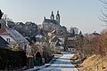
| Location | Maria Saal, Klagenfurt-Land District, Carinthia, Austria | ||||
| Street address |
| ||||
| Heritage designation | |||||
 | |||||
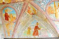
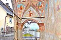
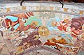
Media in category "Pestkreuz, Maria Saal"
The following 35 files are in this category, out of 35 total.
-
 Maria Saal Arndorfer Strasse Pestkreuz 1523 Gewoelbemalerei 05102010 37.jpg 4,256 × 2,832; 4.62 MB
-
 Maria Saal Arndorfer Strasse Pestkreuz 1523 Gewoelbemalerei 05102010 38.jpg 2,832 × 4,256; 4.7 MB
-
 Maria Saal Arndorfer Strasse Pestkreuz 1523 Loggia Gewoelbemalerei 11012017 5971.jpg 4,286 × 7,262; 17.03 MB
-
 Maria Saal Arndorfer Strasse Pestkreuz Ost-Ansicht 04122013 813.jpg 3,264 × 4,928; 8.77 MB
-
 Maria Saal Arndorfer Strasse Pestkreuz Ost-Ansicht 11012017 4767.jpg 3,280 × 4,928; 10.98 MB
-
 Maria Saal Arndorfer Strasse Pestkreuz Sued-Ansicht 11012017 5967.jpg 4,628 × 6,760; 19.12 MB
-
 Maria Saal Arndorfer Straße Pestkreuz 1523 Gewölbemalerei Evang. Johannes 04022019 6497.jpg 3,210 × 4,823; 13.75 MB
-
 Maria Saal Arndorfer Straße Pestkreuz 1523 Gewölbemalerei Evang. Lukas 04022019 6496.jpg 2,968 × 4,584; 12.97 MB
-
 Maria Saal Arndorfer Straße Pestkreuz 1523 Gewölbemalerei Evang. Markus 04022019 6498.jpg 3,158 × 4,745; 14.81 MB
-
 Maria Saal Arndorfer Straße Pestkreuz 1523 Gewölbemalerei Evang. Matthäus 04022019 6499.jpg 2,922 × 4,692; 14.44 MB
-
 Maria Saal Arndorfer Straße Pestkreuz SW-Ansicht 04022019 6489.jpg 3,056 × 4,928; 10.66 MB
-
 Maria Saal Arndorfer Straße Pestkreuz W-Ansicht 29052008 88.jpg 1,624 × 1,904; 573 KB
-
 Maria Saal Arndorfer Straße Pestkreuz WNW-Ansicht 04022019 6484.jpg 3,280 × 4,928; 10.02 MB
-
-
 Maria Saal Arndorfer Strasse Pestkreuz 1523 Gewoelbemalerei 05102010 34.jpg 4,256 × 2,832; 5.07 MB
-
 Maria Saal Arndorfer Strasse Pestkreuz 1523 Gewoelbemalerei 05102010 35.jpg 4,256 × 2,832; 4.58 MB
-
 Maria Saal Arndorfer Strasse Pestkreuz 1523 Gewoelbemalerei 05102010 36.jpg 4,256 × 2,832; 3.74 MB
-
 Maria Saal Arndorfer Strasse Pestkreuz 1523 Gewoelbemalerei 05102010 39.jpg 2,832 × 4,256; 5.15 MB
-
 Maria Saal Arndorfer Strasse Pestkreuz 1523 S-Ansicht mit Wandmalereien 04122013 814.jpg 4,928 × 3,264; 12.12 MB
-
 Maria Saal Arndorfer Strasse Pestkreuz 1523 S-Ansicht mit Wandmalereien 04122013 815.jpg 4,928 × 3,264; 12.24 MB
-
 Maria Saal Arndorfer Strasse Pestkreuz 1523 Wandmalerei an O-Wand 04122013 829.jpg 4,928 × 3,264; 15 MB
-
 Maria Saal Arndorfer Strasse Pestkreuz 1523 Wandmalerei an O-Wand 04122013 830.jpg 4,928 × 3,264; 14.34 MB
-
 Maria Saal Arndorfer Strasse Pestkreuz 1523 Wandmalerei an W-Wand 04122013 831.jpg 4,928 × 3,264; 15.22 MB
-
 Maria Saal Arndorfer Strasse Pestkreuz 1523 Wandmalerei an W-Wand 04122013 832.jpg 4,928 × 3,264; 13.15 MB
-
 Maria Saal Arndorfer Strasse Pestkreuz 1523 Wandmalerei an W-Wand 04122013 833.jpg 4,928 × 3,264; 15.14 MB
-
 Maria Saal Arndorfer Strasse Pestkreuz 1523 Wandmalerei Kreuzigungsmotiv 04122013 820.jpg 4,928 × 3,264; 14.6 MB
-
 Maria Saal Arndorfer Strasse Pestkreuz 1523 Wandmalerei Kreuzigungsmotiv 05102010 40.jpg 4,256 × 2,832; 4.72 MB
-
 Maria Saal Arndorfer Straße Pestkreuz 1523 Wandmalerei an W-Wand 04022019 6495.jpg 4,928 × 3,280; 12.52 MB
-
 Maria Saal Pestkreuz 04122013 811.jpg 4,928 × 3,264; 10.35 MB
-
 Maria Saal Pestkreuz Gewoelbefresko hl Geist und vier Evangelisten 04122013 821.jpg 4,928 × 3,264; 13.76 MB
-
 Maria Saal Pestkreuz Gewoelbefresko Lukas und Johannes 04122013 834.jpg 4,928 × 3,264; 15.92 MB
-
 Maria Saal Pestkreuz Gewoelbefresko Matthaeus und Markus 04122013 828.jpg 4,928 × 3,264; 14.48 MB
-
 Maria Saal Pestkreuz NO-Gewoelbe Schoenschrift-Text 04122013 824.jpg 4,928 × 3,264; 16.54 MB
-
 Maria Saal Pestkreuz NW-Gewoelbe Schoenschrift-Text 04122013 822.jpg 4,928 × 3,264; 13.63 MB
-
 Maria Saal Pestkreuz NW-Gewoelbe Schoenschrift-Text 04122013 823.jpg 4,928 × 3,264; 14.03 MB


