Category:Pfarrkirche Pottenbrunn
Jump to navigation
Jump to search
| Object location | | View all coordinates using: OpenStreetMap |
|---|
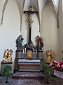
church building in St. Pölten, Austria  | |||||
| Upload media | |||||
| Instance of | |||||
|---|---|---|---|---|---|
| Named after | |||||
| Location | St. Pölten, Lower Austria, Austria | ||||
| Street address |
| ||||
| Heritage designation | |||||
 | |||||
Media in category "Pfarrkirche Pottenbrunn"
The following 11 files are in this category, out of 11 total.
-
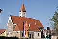 Kirche Pottenbrunn.jpg 3,872 × 2,592; 1.82 MB
-
 Pfarrkirche Pottenbrunn Altar.JPG 3,056 × 4,592; 4.24 MB
-
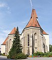 Pfarrkirche Pottenbrunn.jpg 4,149 × 4,779; 13.68 MB
-
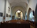 Pottenbrunn Pfarrkirche1.jpg 3,648 × 2,736; 4.01 MB
-
 Pottenbrunn Pfarrkirche2.jpg 3,648 × 2,736; 5.23 MB
-
 Pottenbrunn Pfarrkirche3.jpg 2,736 × 3,648; 3.88 MB
-
 Pottenbrunn Pfarrkirche4.jpg 2,736 × 3,648; 3.52 MB
-
 Pottenbrunn Pfarrkirche5.jpg 2,736 × 3,648; 3.67 MB
-
 St Pölten, Austria - panoramio (6).jpg 2,592 × 1,936; 1.25 MB
-
 St Pölten, Austria - panoramio (7).jpg 2,592 × 1,936; 1.43 MB
-
 St Pölten, Austria - panoramio (8).jpg 2,592 × 1,936; 1.34 MB


.jpg)
.jpg)
.jpg)