Category:Pfarrkirche Spratzern
Jump to navigation
Jump to search
| Object location | | View all coordinates using: OpenStreetMap |
|---|
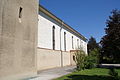
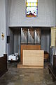
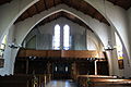
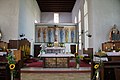
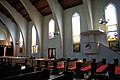
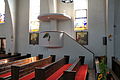
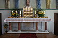
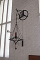
church building in St. Pölten, Austria  | |||||
| Upload media | |||||
| Instance of | |||||
|---|---|---|---|---|---|
| Location | St. Pölten, Lower Austria, Austria | ||||
| Heritage designation | |||||
 | |||||
Subcategories
This category has only the following subcategory.
Media in category "Pfarrkirche Spratzern"
The following 42 files are in this category, out of 42 total.
-
 Kirche Spratzern.JPG 3,872 × 2,592; 3.7 MB
-
 Pfarrkirche Spratzern 001.JPG 3,056 × 4,592; 5.49 MB
-
 Pfarrkirche Spratzern 002.JPG 4,592 × 3,056; 7.63 MB
-
 Pfarrkirche Spratzern 003.JPG 4,592 × 3,056; 3.86 MB
-
 Pfarrkirche Spratzern 004.JPG 3,056 × 4,592; 4.06 MB
-
 Pfarrkirche Spratzern 005.JPG 4,592 × 3,056; 8.06 MB
-
 Pfarrkirche Spratzern 006.JPG 4,592 × 3,056; 6.91 MB
-
 Pfarrkirche Spratzern 007.JPG 4,592 × 3,056; 3.16 MB
-
 Pfarrkirche Spratzern 008.JPG 4,592 × 3,056; 4.38 MB
-
 Pfarrkirche Spratzern 020.JPG 4,592 × 3,056; 5.63 MB
-
 Pfarrkirche Spratzern 021.JPG 3,056 × 4,592; 3.94 MB
-
 Pfarrkirche Spratzern 022.JPG 4,592 × 3,056; 4.53 MB
-
 Pfarrkirche Spratzern 023.JPG 4,592 × 3,056; 2.98 MB
-
 Pfarrkirche Spratzern 024.JPG 4,592 × 3,056; 3.09 MB
-
 Pfarrkirche Spratzern 025.JPG 4,592 × 3,056; 5.78 MB
-
 Pfarrkirche Spratzern 026.JPG 3,056 × 4,592; 2.79 MB
-
 Pfarrkirche Spratzern 027.JPG 4,592 × 3,056; 5.25 MB
-
 Pfarrkirche Spratzern 028.JPG 4,592 × 3,056; 4.06 MB
-
 Pfarrkirche Spratzern 030.JPG 4,592 × 3,056; 3.88 MB
-
 Pfarrkirche Spratzern 031.JPG 4,592 × 3,056; 4.81 MB
-
 Pfarrkirche Spratzern 032.JPG 3,056 × 4,592; 3.86 MB
-
 Pfarrkirche Spratzern 033.JPG 4,592 × 3,056; 5.88 MB
-
 Pfarrkirche Spratzern 034.JPG 4,592 × 3,056; 6.03 MB
-
 Pfarrkirche Spratzern 035.JPG 3,056 × 4,592; 3.46 MB
-
 Pfarrkirche Spratzern 036.JPG 4,592 × 3,056; 2.8 MB
-
 Pfarrkirche Spratzern 037.JPG 3,056 × 4,592; 3.92 MB
-
 Pfarrkirche Spratzern 038.JPG 3,056 × 4,592; 3.16 MB
-
 Pfarrkirche Spratzern 039.JPG 4,592 × 3,056; 4.72 MB
-
 Pfarrkirche Spratzern 040.JPG 3,056 × 4,592; 3.8 MB
-
 Pfarrkirche Spratzern 043.JPG 2,078 × 3,134; 1.47 MB
-
 Pfarrkirche Spratzern 044.JPG 4,592 × 3,056; 3.69 MB
-
 Pfarrkirche Spratzern 045.JPG 4,592 × 3,056; 4.19 MB
-
 Pfarrkirche Spratzern 046.JPG 3,056 × 4,592; 3.39 MB
-
 Pfarrkirche Spratzern 047.JPG 3,056 × 4,592; 3.82 MB
-
 Pfarrkirche Spratzern 050.JPG 4,592 × 3,056; 5.03 MB
-
 Pfarrkirche Spratzern 051.JPG 4,592 × 3,056; 5.22 MB
-
 Pfarrkirche Spratzern 054.JPG 4,592 × 3,056; 3.93 MB
-
 Pfarrkirche Spratzern 055.JPG 3,056 × 4,592; 2.53 MB
-
 Pfarrkirche Spratzern 056.JPG 4,592 × 3,056; 4.63 MB
-
 Pfarrkirche Spratzern 057.JPG 3,056 × 4,592; 5.27 MB
-
 Pfarrkirche Spratzern 058.JPG 3,056 × 4,592; 4.9 MB
-
 Pfarrkirche Wagram Bleiglas Pfarrkirche Spratzern.JPG 2,567 × 3,850; 2.44 MB


