Category:Pfarrkirche Vösendorf
Jump to navigation
Jump to search
| Object location | | View all coordinates using: OpenStreetMap |
|---|
| This category shows the protected monument with the number 56084 in Austria. (Commons, de, Wikidata) |
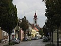
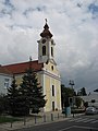
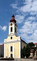
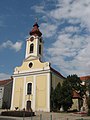
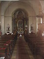
building in Vösendorf, Lower Austria, Austria  | |||||
| Upload media | |||||
| Instance of | |||||
|---|---|---|---|---|---|
| Location | Vösendorf, Mödling District, Lower Austria, Austria | ||||
| Street address |
| ||||
| Architectural style | |||||
| Heritage designation | |||||
 | |||||
Media in category "Pfarrkirche Vösendorf"
The following 12 files are in this category, out of 12 total.
-
 Vösendorf 07.JPG 3,072 × 2,304; 1.62 MB
-
 Vösendorf 12.JPG 2,304 × 3,072; 1.4 MB
-
 Vösendorf 13-2.JPG 2,024 × 3,334; 4.18 MB
-
 Vösendorf 13.JPG 2,304 × 3,072; 1.45 MB
-
 Vösendorf 14.JPG 2,304 × 3,072; 1.37 MB
-
 Vösendorf 15.JPG 2,304 × 3,072; 2.46 MB
-
 Vösendorf 16.JPG 3,072 × 2,304; 1.97 MB
-
 Vösendorf 19.JPG 3,072 × 2,304; 2.37 MB
-
 Vösendorf 20.JPG 3,072 × 2,304; 1.97 MB
-
 Vösendorf 21.JPG 2,682 × 2,202; 1.71 MB
-
 Vösendorf 22.JPG 3,072 × 2,304; 2.16 MB
-
 Vösendorf 23.JPG 3,072 × 2,304; 3.16 MB


