Category:Pranger, Hirschbach
Jump to navigation
Jump to search
| Object location | | View all coordinates using: OpenStreetMap |
|---|
 | |||||
| Upload media | |||||
| Instance of | |||||
|---|---|---|---|---|---|
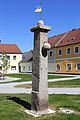
| Location | Hirschbach, Gmünd District, Lower Austria, Austria | ||||
| Heritage designation | |||||
 | |||||
Media in category "Pranger, Hirschbach"
The following 4 files are in this category, out of 4 total.
-
 Pfarrkirche Kreuzerhöhung in Hirschbach.jpg 3,000 × 4,500; 7.45 MB
-
 Pranger in Hirschbach 02 2016-08.jpg 4,800 × 3,600; 6.81 MB
-
 Pranger in Hirschbach 2016-08.jpg 3,200 × 4,800; 7.92 MB
-
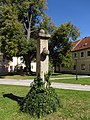 Pranger in Hirschbach.jpg 2,736 × 3,648; 1.42 MB


