Category:Rainerhof, Klagenfurt
Jump to navigation
Jump to search
| Object location | | View all coordinates using: OpenStreetMap |
|---|
building in Klagenfurt, Austria  | |||||
| Upload media | |||||
| Instance of | |||||
|---|---|---|---|---|---|
| Location | Klagenfurt, Carinthia, Austria | ||||
| Street address |
| ||||
| Heritage designation | |||||
 | |||||
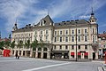
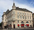
English: Rainerhof on Neuer Platz #5 & 6 (north side), setup 1885-1887 by Friedrich Schachner, in Klagenfurt inner city, district Klagenfurt, Carinthia, Austria
Deutsch: Rainerhof, Neuer Platz 5 & 6 (Nord-Seite), erbaut 1885-1887 von Friedrich Schachner in Klagenfurt-Innere Stadt, Bezirk Klagenfurt, Kärnten, Österreich
| This category shows the protected monument with the number 45611 in Austria. (Commons, de, Wikidata) |
Media in category "Rainerhof, Klagenfurt"
The following 10 files are in this category, out of 10 total.
-
 Klagenfurt Innere Stadt Neuer Platz 6 Rainerhof Süd-Ansicht 25042009 54.jpg 3,328 × 2,024; 1.39 MB
-
 Klagenfurt Neuer Platz 6 Rainerhof Konsolen-Balkon 23072016 3941.jpg 4,742 × 3,280; 7.19 MB
-
 Klagenfurt Neuer Platz 6 Rainerhof SO-Ansicht 23072016 3943.jpg 2,972 × 4,507; 6.43 MB
-
 Klagenfurt Neuer Platz 6 Rainerhof SW-Erker 23072016 3937.jpg 2,157 × 4,559; 3.65 MB
-
 Klagenfurt Neuer Platz 6 Rainerhof SW-Erker unterer Teil 23072016 3936.jpg 2,702 × 4,855; 5.53 MB
-
 Klagenfurt - Haus Neuer Platz 5.JPG 4,272 × 2,848; 4.46 MB
-
 Klagenfurt - Neuer Platz Nr5.jpg 3,030 × 2,635; 1.77 MB
-
 Klagenfurt 2018(1) 04.jpg 1,952 × 2,293; 532 KB
-
 Klagenfurt Baustelle Neuer Platz Lindwurm 16082007 01.jpg 2,848 × 2,136; 1.33 MB
-
 Lindwurmbrunnen Süden.JPG 6,016 × 4,016; 18.63 MB


_04.jpg)

