Category:Schloss Rothenthurn bei Molzbichl
Jump to navigation
Jump to search
| This category shows the protected monument with the number 34727 in Austria. (Commons, de, Wikidata) |
| Object location | | View all coordinates using: OpenStreetMap |
|---|
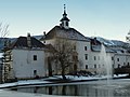
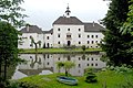
building in Spittal an der Drau, Austria  | |||||
| Upload media | |||||
| Instance of | |||||
|---|---|---|---|---|---|
| Location | Spittal an der Drau, Spittal an der Drau District, Carinthia, Austria | ||||
| Heritage designation | |||||
 | |||||
Media in category "Schloss Rothenthurn bei Molzbichl"
The following 7 files are in this category, out of 7 total.
-
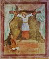 Rothenthurn hl.Kümmernis.jpg 2,387 × 2,870; 1.36 MB
-
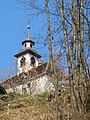
 Rothenthurn Kapelle.JPG 4,794 × 3,534; 2.6 MB
-
 Rothenthurn Schloss.JPG 1,920 × 2,560; 1.81 MB
-
 Rothenthurn Schlossteich.JPG 1,920 × 2,560; 2.62 MB
-
 Schloss Rothenthurn mit Teich.JPG 2,560 × 1,920; 2.01 MB
-
 Schloss Rothenthurn.JPG 1,352 × 2,183; 1.28 MB
-
 Spittal Rothenthurn Schloss 17052007 07.jpg 3,872 × 2,592; 1.57 MB


