Category:Straßenbrücke, Enns, Ennsdorf
Jump to navigation
Jump to search
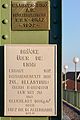
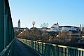
Deutsch: Diese Brücke verbindet Enns und Ennsdorf. Von 1945 bis 1955 war hier die Demarkationslinie zwischen der amerikanischen und der sowjetischen Zone.
English: This bridge is connecting Enns and Ennsdorf. From 1945 to 1955 it was the border between the American and the Soviet sector of Austria.
| This category shows the protected monument with the number 116943 in Austria. (Commons, de, Wikidata) |
| Object location | | View all coordinates using: OpenStreetMap |
|---|
bridge in Austria  | |||||
| Upload media | |||||
| Instance of | |||||
|---|---|---|---|---|---|
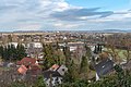
| Location | Enns, Linz-Land District, Upper Austria, Austria | ||||
| Street address |
| ||||
| Heritage designation | |||||
 | |||||
Media in category "Straßenbrücke, Enns, Ennsdorf"
The following 8 files are in this category, out of 8 total.
-
 Enns Brücke Schild.jpg 3,166 × 4,749; 3.58 MB
-
 Enns Brücke Turm OW.jpg 5,824 × 3,879; 3.57 MB
-
 Enns Brücke Turm Schloss UW.jpg 5,847 × 3,898; 3.62 MB
-
 Enns Brücke Turm von Ennsdorf OW.jpg 5,923 × 3,948; 4.15 MB
-
 Enns Reintal und Ennsdorf-9598.jpg 5,492 × 3,661; 14.12 MB
-
 Enns Reintal und Ennsdorf-9599.jpg 5,413 × 3,609; 14.35 MB
-
 Enns Straßenbrücke über die Enns.JPG 4,251 × 2,794; 2.43 MB
-
 Ennsdorf und Enns Reintal-9597.jpg 5,145 × 3,430; 12.44 MB


