Category:Triangulation point, Mühlau
Jump to navigation
Jump to search
 | |||||
| Upload media | |||||
| Instance of | |||||
|---|---|---|---|---|---|
| Location | Innsbruck, Tyrol, Austria | ||||
| Street address |
| ||||
| Heritage designation | |||||
 | |||||
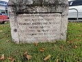
Deutsch: Österreichische Landesvermessung Westlicher Endpunkt der Grundlinie Hall - Innsbruck, 1851
| This category shows the protected monument with the number 98266 in Austria. (Commons, de, Wikidata) |
|
This category shows the remarkable cultural object in the Austrian state of Tyrol listed by the Tyrolean Art Cadastre with the ID
115953. (on tirisMaps, pdf, more images on Commons, Wikidata) |
Media in category "Triangulation point, Mühlau"
The following 3 files are in this category, out of 3 total.
-
 Vermessungspunkt1.JPG 3,648 × 2,736; 4.21 MB
-
 Vermessungspunkt2.JPG 3,648 × 2,736; 4.27 MB
-
 Vermessungspunkt3.JPG 3,648 × 2,736; 4.17 MB

