Category:Wegkapelle Großlobming
Jump to navigation
Jump to search
| Object location | | View all coordinates using: OpenStreetMap |
|---|
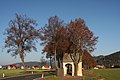
building in Großlobming, Austria  | |||||
| Upload media | |||||
| Instance of | |||||
|---|---|---|---|---|---|
| Location | Lobmingtal, Murtal District, Styria, Austria | ||||
| Street address |
| ||||
| Heritage designation | |||||
 | |||||
Wegkapelle und Feldkreuz Großlobming
Media in category "Wegkapelle Großlobming"
The following 4 files are in this category, out of 4 total.
-
 AT-80539 - Wegkapelle in Großlobming01.JPG 2,736 × 3,648; 3.03 MB
-
 AT-80539 - Wegkapelle in Großlobming02.JPG 2,736 × 3,648; 2.76 MB
-
 Bei Großlobming - panoramio.jpg 2,000 × 1,333; 1.26 MB
-
 Wegkapelle Feldkreuz Grosslobming.jpg 3,332 × 5,104; 3.52 MB


