Zur Beschreibungsseite auf Commons

Datei:1768 James Craig Map of New Town, Edinburgh, Scotland (First Plan of New Town) - Geographicus - Edinburgh-craig-1768.jpg

aus Wikipedia, der freien Enzyklopädie
Zur Navigation springen Zur Suche springen
Originaldatei(5.000 × 3.508 Pixel, Dateigröße: 6,08 MB, MIME-Typ: image/jpeg)

Diese Datei und die Informationen unter dem roten Trennstrich werden aus dem zentralen Medienarchiv Wikimedia Commons eingebunden.

Zur Beschreibungsseite auf Commons


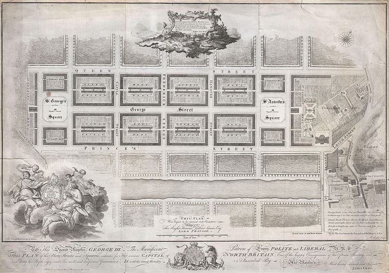
Plan of the New Streets and Squares intended for the city of Edinburgh.
Künstler
Titel
Plan of the New Streets and Squares intended for the city of Edinburgh.
Beschreibung
English: Drafted for the city planning committee in 1768 by James Craig, this is the definitive plan of Edinburgh, Scotland’s New Town. Oriented to the North, this plan details the streets of Edinburgh north of the Loch Nor (today the Prince’s Street Gardens) between St. George’s Square (modern day Charlotte Square) and St. Andrews Square. A dedication to King George the III illustrates the lower part of the map. An elaborate title cartouche decorates the lower left hand quadrant. Thompson’s poem appears in a secondary cartouche at the top center. In 1766 the City Fathers of Edinburgh lead by Lord Provost George Drummond instituted a plan to extend the city’s border to encompass the field’s north of the Nor Loch. The plan, intended to modernize the city and ease the crowded conditions of the old Royal Burgh, was turned into a competition. James Craig, an Edinburgh native, having around this time just completed his apprenticeship as a mason, found the he had a fine hand for drafting. Inspired by his uncle James Thomson’s well known poem Liberty , August, around, what Public Works I see, Lo’ stately Streets, lo’ Squares that Court the breeze, See’ long Canals, and deepened Rivers join Eash part with each, and with the circling Main The whole enlivened Isle… Craig submitted this plan. Though conservative in its vision, Craig’s plan won the city’s design contest and he was awarded with the “Freedom of the City” in 1767. Sadly the Lord Provost George Drummond who instituted the contest died before his dream of expanding the city was realized. It was left to his successor, the Lord Provost Gilbert Laurie, who is named on this map, to realize Craig’s plan. Today the streets are laid out much as Craig envisioned them with broad east –west avenues separating housing blocks bisected by smaller mews. Drawn by James Craig and engraved by P. Begbie in 1768. When this plan was printed in 1768, only 500 were issued. With such a small printing run as an independently issued map, we can safely assume that very few examples, other than the one you see here, have survived to this day. Only one recorded example of this map has appeared at auction in the last 30 years. Dated and copyrighted “Published according to Act of Parliament, Jan. 1st, 1768.
Datum 1768 (dated)
Maße Höhe: 18 in (45,7 cm); Breite: 26 in (66 cm)
dimensions QS:P2048,18U218593
dimensions QS:P2049,26U218593
Inventarnummer
Geographicus link: Edinburgh-craig-1768
Herkunft/Fotograf
Genehmigung
(Weiternutzung dieser Datei)
Dies ist eine originalgetreue fotografische Reproduktion eines zweidimensionalen Kunstwerks. Das Kunstwerk an sich ist aus dem folgenden Grund gemeinfrei:
Public domain

Dieses Werk ist gemeinfrei, weil seine urheberrechtliche Schutzfrist abgelaufen ist.
Dies gilt für das Herkunftsland des Werks und alle weiteren Staaten mit einer gesetzlichen Schutzfrist von 100 oder weniger Jahren nach dem Tod des Urhebers.


Parallel zu dieser Lizenz muss auch ein Lizenzbaustein für die United States public domain gesetzt werden, um anzuzeigen, dass dieses Werk auch in den Vereinigten Staaten gemeinfrei ist.
Nach offizieller Ansicht der Wikimedia Foundation sind originalgetreue Reproduktionen zweidimensionaler gemeinfreier Werke gemeinfrei. Diese fotografische Reproduktion wird daher auch als gemeinfrei in den Vereinigten Staaten angesehen. Die Verwendung dieser Werke kann in anderen Rechtssystemen verboten oder nur eingeschränkt erlaubt sein. Zu Details siehe Reuse of PD-Art photographs.

Kurzbeschreibungen

Ergänze eine einzeilige Erklärung, was diese Datei darstellt.

In dieser Datei abgebildete Objekte

Motiv

image/jpeg

d77403877c867d6b8f622485ff0d65fc8369261d

6.378.004 Byte

3.508 Pixel

5.000 Pixel

Dateiversionen

Klicke auf einen Zeitpunkt, um diese Version zu laden.

Version vomVorschaubildMaßeBenutzerKommentar
aktuell23:16, 22. Mär. 2011Vorschaubild der Version vom 23:16, 22. Mär. 20115.000 × 3.508 (6,08 MB)BotMultichillT{{subst:User:Multichill/Geographicus |link=http://www.geographicus.com/P/AntiqueMap/Edinburgh-craig-1768 |product_name=1768 James Craig Map of New Town, Edinburgh, Scotland (First Plan of New Town) |map_title=Plan of the New Streets and Squares intended

Die folgenden 2 Seiten verwenden diese Datei:

Globale Dateiverwendung