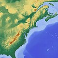
Datei:Appalachian mountains landform configuration.jpg

Originaldatei (10.000 × 10.000 Pixel, Dateigröße: 43,4 MB, MIME-Typ: image/jpeg)
![]()
Diese Datei und die Informationen unter dem roten Trennstrich werden aus dem zentralen Medienarchiv Wikimedia Commons eingebunden.
Beschreibung
| Warnung | Diese Originaldatei ist sehr hochauflösend. Es könnte sein, dass diese Datei nicht richtig geladen werden kann oder dass der Browser einfriert, wenn die Datei in voller Größe geöffnet wird. Um diese Probleme zu vermeiden, kann der interaktive Bildbetrachter (ZoomViewer) verwendet werden. |
|---|
| BeschreibungAppalachian mountains landform configuration.jpg |
English: Rendered landform configuration of the Appalachian mountains and the US east coast region by maps-for-free.com. DEM data derived from the Shuttle Radar Topography Mission (SRTM). |
|||
| Datum | ||||
| Quelle | maps-for-free.com | |||
| Urheber |
The vision of Maps-For-Free is to offer free worldwide relief maps and other layers which can easily be integrated into existing map projects. MFF-maps are released under Creative Commons CC0. You are free to adapt and use the relief maps and relief layer for commercial purposes without attributing the original author or source. Although not required, a link to maps-for-free.com is appreciated. SRTM SRTM (Shuttle Radar Topography Mission) was developed to collect three-dimensional measurements of the Earth's surface to generate a near-global digital elevation model (DEM). The mission was a cooperative project between the National Aeronautics and Space Administration (NASA), the National Geospatial-Intelligence Agency (NGA) of the U.S. Department of Defense (DoD), and the German and Italian space agencies. SRTM flew on board the Space Shuttle Endeavour in February 2000 and used an interferometric radar system to map the topography of Earth's surface. Endeavour was launched in an orbit with an inclination of 57 degrees which allowed to map all of the Earth's landmass that lies between 60 degrees North and 56 degrees South. SRTM data was processed into geographic tiles, each of which represents one by one degree of latitude and longitude. A degree of latitude measures 111 kilometers North South, a degree of longitude measures 111 kilometers East West or less, decreasing away from the equator. Each tile of this dataset contains 1201x1201 samples which is equipollent to a 90 m grid resolution at equator. All tiles together represent an image sized 432000 x 139200 pixel. For technical reasons data are available between 60 degrees North and 56 degrees South latitud only. The relative horizontal accuracy is about ± 15 m, the relative vertical accuracy about ± 6 m. The original data came with data voids indicating insufficient contrast in the radar data. These data voids tend to occur over water bodies (lakes, rivers, coasts, etc.), areas with snow cover and in mountainous regions. The original SRTM data are available from USGS. GTOPO30 GTOPO30 is another free geographic dataset with a resolution of 43200 x 21600 pixel used to cover regions where SRTM data are not available. Streaky regions denote areas where data voids were extrapolated or where SRTM data were replaced by the lower resolution GTOPO30 data. The relief maps are elevation maps, i.e. the coloring does not reflect the natural colors of scenic objects. Because one color is used for each ground level, some rivers and other objects may appear in unnatural colors. Lowland areas containing only few elevation information appear most likely single-colored. In some cases the SRTM or GTOPO30 dataset failed to include small islands, and in other cases the islands are slightly mispositioned. The GTOPO data are also available from USGS. |
|||
| Andere Versionen |
|
Lizenz
| Diese Datei wird unter der Creative-Commons-Lizenz „CC0 1.0 Verzicht auf das Copyright“ zur Verfügung gestellt. | |
| Die Person, die das Werk mit diesem Dokument verbunden hat, übergibt dieses weltweit der Gemeinfreiheit, indem sie alle Urheberrechte und damit verbundenen weiteren Rechte – im Rahmen der jeweils geltenden gesetzlichen Bestimmungen – aufgibt. Das Werk kann – selbst für kommerzielle Zwecke – kopiert, modifiziert und weiterverteilt werden, ohne hierfür um Erlaubnis bitten zu müssen.
http://creativecommons.org/publicdomain/zero/1.0/deed.enCC0Creative Commons Zero, Public Domain Dedicationfalsefalse |
Kurzbeschreibungen
In dieser Datei abgebildete Objekte
Motiv
10. November 2017
image/jpeg
0a88789bc5745c40fcc838044fc6fcc67b4e284b
45.504.895 Byte
10.000 Pixel
10.000 Pixel
Dateiversionen
Klicke auf einen Zeitpunkt, um diese Version zu laden.
| Version vom | Vorschaubild | Maße | Benutzer | Kommentar | |
|---|---|---|---|---|---|
| aktuell | 00:23, 11. Nov. 2017 |  | 10.000 × 10.000 (43,4 MB) | Morty | User created page with UploadWizard |
Dateiverwendung
Die folgende Seite verwendet diese Datei:
