Datei:Fort St David map 1758.jpg
Originaldatei (994 × 1.354 Pixel, Dateigröße: 176 KB, MIME-Typ: image/jpeg)
![]()
Diese Datei und die Informationen unter dem roten Trennstrich werden aus dem zentralen Medienarchiv Wikimedia Commons eingebunden.
![]()
Beschreibung
| Beschreibung |
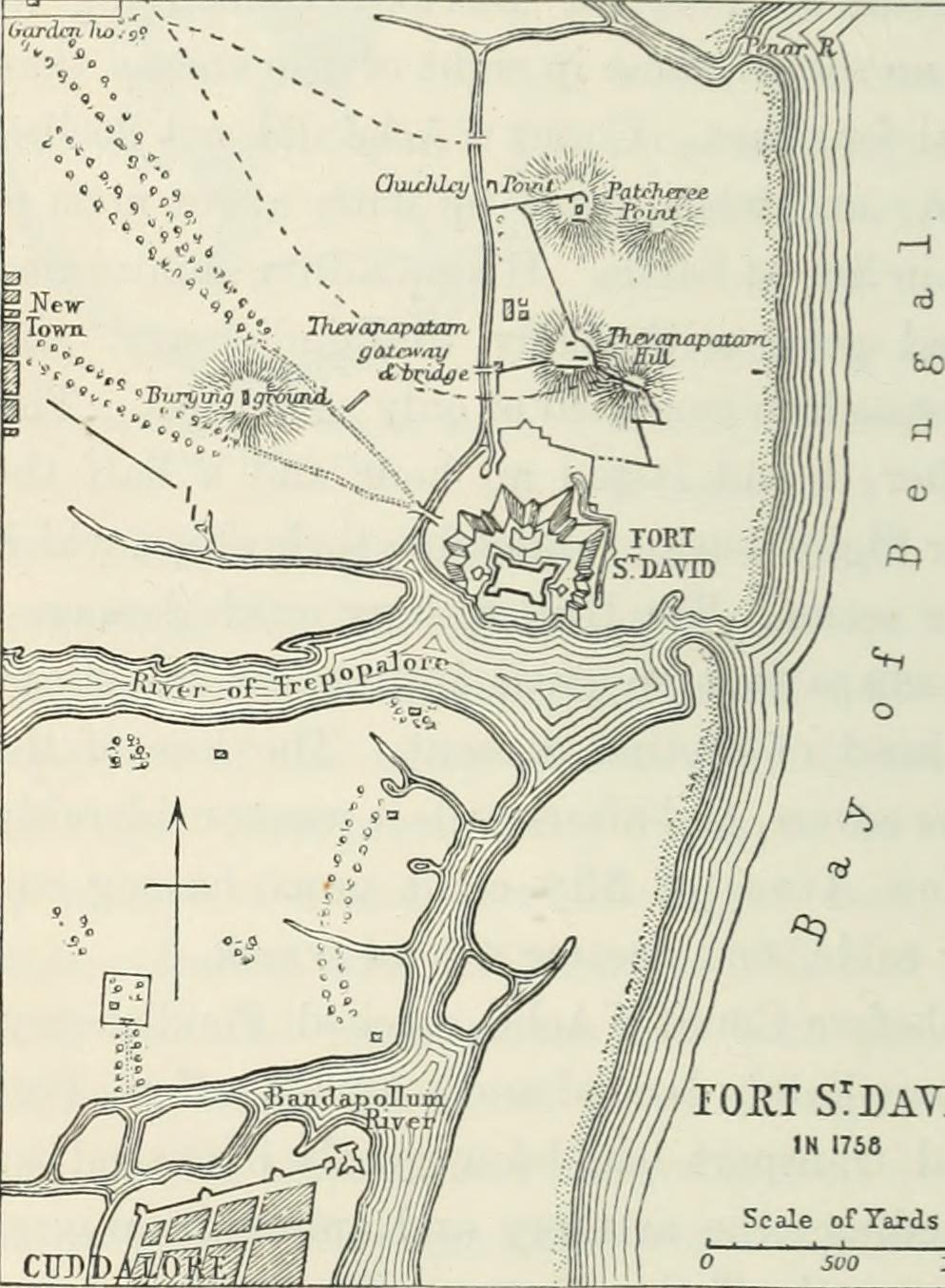
Identifier: comprehensivehis01beve Title: A comprehensive history of India, civil, military, and social, from the first landing of the English to the suppression of the Sepoy revolt; including an outline of the early history of Hindoostan Year: 1900 (1900s) Authors: Beveridge, Henry, 1837-1929 Subjects: Publisher: London, Blackie Contributing Library: Robarts - University of Toronto Digitizing Sponsor: University of Toronto
Click here to view book online to see this illustration in context in a browseable online version of this book.
Text Appearing After Image: CountdAchcdeclines thecliallenge ofthe Britislifleet. over his opponent, it was natur-ally expected that he would notallow Fort St. David to fallwithout a strenuous effort tosave it. He did indeed makethis effort; and after ha\-ing beendriven northward as far asSadrass, had worked his wayback, but with so much diffi-culty, that he only gained fourleagues in two days. On the28th he descried the French fleetlying in the road to Pondicherry;but Count dAches courage hadcooled after his pre%ious encoun-ter, and instead of accepting thechallenge to fight, he resolved,with the sanction of his captainsand the governor and council, tokeep his ships moored near the shore under the protection of the batteries.Lally, hearing of this resolution and ashamed of it, hastened firom the siege,bringing with him a detachment of 400 Europeans and as many sepoys, whomlie tendered to Count dAche to serve on board the fleet. The want of men, inconsequence of the great number of sick who were on shore in the
|
| Quelle | Image from page 631 of "A comprehensive history of India, civil, military, and social, from the first landing of the English to the suppression of the Sepoy revolt; including an outline of the early history of Hindoostan" (1900) |
| Urheber | Internet Archive Book Images |
| Genehmigung (Weiternutzung dieser Datei) |
Internet Archive Book Images @ Flickr Commons |
Lizenz
Dieses Bild wurde von Flickrs The Commons übernommen. Die hochladende Organisation kann verschiedene Gründe für die Feststellung haben, dass keine bekannten Urheberrechtsbeschränkungen bestehen, wie z. B.:
Weitere Informationen findest du unter https://flickr.com/commons/usage/. Bitte füge zusätzliche Lizenzvorlagen zu diesem Bild hinzu, wenn genauere Informationen zum Urheberrechts-Status ermittelt werden können. Siehe Commons:Licensing für weitere Informationen. |
| Diese Bilddatei wurde ursprünglich auf Flickr durch Internet Archive Book Images in https://www.flickr.com/photos/126377022@N07/14578176150 hochgeladen. Sie wurde am 4. April 2015 durch den FlickreviewR-Bot geprüft und die Lizenzierung der Datei unter den Bedingungen von No known copyright restrictions wurde bestätigt. |
Dateiversionen
Klicke auf einen Zeitpunkt, um diese Version zu laden.
| Version vom | Vorschaubild | Maße | Benutzer | Kommentar | |
|---|---|---|---|---|---|
| aktuell | 22:12, 4. Apr. 2015 | | 994 × 1.354 (176 KB) | Nizil Shah | Transferred from Flickr via Flickr2Commons |
Dateiverwendung
Die folgende Seite verwendet diese Datei:
Globale Dateiverwendung
Die nachfolgenden anderen Wikis verwenden diese Datei:
- Verwendung auf en.wikipedia.org
- Verwendung auf mr.wikipedia.org
- Verwendung auf ta.wikipedia.org
- Verwendung auf www.wikidata.org