Datei:Nps1753-54.png
Zur Navigation springen
Zur Suche springen

Größe dieser Vorschau: 800 × 374 Pixel. Weitere Auflösungen: 320 × 150 Pixel | 640 × 299 Pixel | 1.024 × 479 Pixel | 1.280 × 599 Pixel | 2.446 × 1.144 Pixel
Originaldatei (2.446 × 1.144 Pixel, Dateigröße: 1,84 MB, MIME-Typ: image/png)
![]()
Diese Datei und die Informationen unter dem roten Trennstrich werden aus dem zentralen Medienarchiv Wikimedia Commons eingebunden.
![]()
Beschreibung
| Beschreibung |
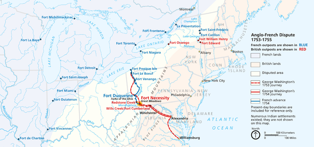
English: Maps of the English and French Campaigns in the Ohio Valley, 1753-54.
PNG file created via a screenshot of the flash map at the Fort Necessity National Battlefield Website (National Park Service) |
| Datum | Unbekanntes Datum |
| Quelle | National Park Service |
| Urheber | Autor/-in unbekannt |
Lizenz
| Diese Datei ist ein Werk eines Mitarbeiters des National Park Service (NPS) der Vereinigten Staaten, aufgenommen oder hergestellt während seiner offiziellen Anstellung. Als ein amtliches Werk der Bundesregierung der Vereinigten Staaten ist dieses Bild gemeinfrei. (Nähere Informationen dazu sind auf der offiziellen Website des NPS verfügbar.) |
Dateiversionen
Klicke auf einen Zeitpunkt, um diese Version zu laden.
| Version vom | Vorschaubild | Maße | Benutzer | Kommentar | |
|---|---|---|---|---|---|
| aktuell | 20:42, 22. Sep. 2010 | | 2.446 × 1.144 (1,84 MB) | NordNordWest | higher resolution |
| 21:29, 22. Aug. 2010 |  | 1.134 × 559 (768 KB) | Janneman | {{Information |Description={{en|1=Maps of the English and French Campaigns in the Ohio Valley, 1753-54. PNG file created via a screenshot of the flash map at the [http://www.nps.gov/fone/index.htm Fort Necessity National Battlefield Website] (National Par |
Dateiverwendung
Keine Seiten verwenden diese Datei.