Datei:Tornado Alley.png
Tornado_Alley.png (550 × 406 Pixel, Dateigröße: 40 KB, MIME-Typ: image/png)
![]()
Diese Datei und die Informationen unter dem roten Trennstrich werden aus dem zentralen Medienarchiv Wikimedia Commons eingebunden.
![]()
Beschreibung
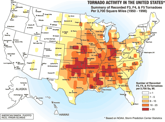
A map of the frequency of F3 and greater intensity tornadoes by area. The darker colors highlight the area typically known as Tornado Alley.
Source: Image from a booklet from Federal Emergency Management Agency, a United States government agency, titled Taking Shelter from the Storm: Building a Safe Room Inside your House, FEMA 320, Figure 1.1, page 3, and thought to be in the public domain.
Area: 700x522 pix
Lizenz
This image is a work of a Federal Emergency Management Agency employee, taken or made as part of that person's official duties. As works of the U.S. federal government, all FEMA images are in the public domain in the United States. Additional media usage information may be found at https://www.fema.gov/photo-video-audio-use-guidelines
|
Dateiversionen
Klicke auf einen Zeitpunkt, um diese Version zu laden.
| Version vom | Vorschaubild | Maße | Benutzer | Kommentar | |
|---|---|---|---|---|---|
| aktuell | 03:00, 15. Feb. 2008 | | 550 × 406 (40 KB) | Mizushimo~commonswiki | == Summary == A map of the frequency of F3 and greater intensity tornadoes by area. The darker colors highlight the area typically known as Tornado Alley. '''Source:''' Image from a booklet from [http://www.fema.g |
Dateiverwendung
Keine Seiten verwenden diese Datei.
Globale Dateiverwendung
Die nachfolgenden anderen Wikis verwenden diese Datei:
- Verwendung auf it.wikipedia.org
- Verwendung auf ja.wikipedia.org
- Verwendung auf lt.wikipedia.org