„Tharsis (Gradfeld)“ – Versionsunterschied
| [ungesichtete Version] | [ungesichtete Version] |
K →References: {{reflist|2}} |
K →Fossa: doi 10.1029/2000JE001278 ; bibcode = 2007LPI....38.1998S |
||
| Zeile 39: | Zeile 39: | ||
== Fossa == |
== Fossa == |
||
The Tharsis quadrangle is also home to large troughs (long narrow depressions) called fossae in the geographical language used for Mars. Fossae in this area are [[Ulysses Fossae]], [[Olympica Fossae]], [[Ceraunius Fossae]], and [[Tractus Fossae]]. These troughs form when the crust is stretched until it breaks. The stretching can be due to the large weight of a nearby volcano. Studies have shown that the volcanoes of Tharsis caused most of the major fossae on Mars. The stress that caused the fossae and other tectonic features is centered in [[Noctis Labyrinthus]], at 4 S and 253 E. But the center has moved somewhat over time. <ref>{{cite book | last=Carr | first=Michael H. | publisher=Cambridge University Press | isbn= 978-0-521-87201-0 | title= The Surface of Mars |year=2006 | page={{page needed|date=January 2011}} }}</ref> |
The Tharsis quadrangle is also home to large troughs (long narrow depressions) called fossae in the geographical language used for Mars. Fossae in this area are [[Ulysses Fossae]], [[Olympica Fossae]], [[Ceraunius Fossae]], and [[Tractus Fossae]]. These troughs form when the crust is stretched until it breaks. The stretching can be due to the large weight of a nearby volcano. Studies have shown that the volcanoes of Tharsis caused most of the major fossae on Mars. The stress that caused the fossae and other tectonic features is centered in [[Noctis Labyrinthus]], at 4 S and 253 E. But the center has moved somewhat over time. <ref>{{cite book | last=Carr | first=Michael H. | publisher=Cambridge University Press | isbn= 978-0-521-87201-0 | title= The Surface of Mars |year=2006 | page={{page needed|date=January 2011}} }}</ref><ref>{{cite journal | title= Primary centers and secondary concentrations of tectonic activity through time in the western hemisphere of Mars | pages= 20563-20585 | doi = 10.1029/2000JE001278 }}</ref> Fossae/pit craters are common near volcanoes in the Tharsis and Elysium system of volcanoes.<ref>{{cite journal | last1=Skinner |first1= J. |first2= L. |lsat2=Skinner |first3= J.| last3= Kargel |year= 2007 |title= Re-assessment of Hydrovolcanism-based Resurfacing within the Galaxias Fossae Region of Mars |journal= Lunar and Planetary Science | volume=XXXVIII | bibcode = 2007LPI....38.1998S | url=http://www.lpi.usra.edu/meetings/lpsc2007/pdf/1998.pdf | format=PDF }}</ref> A trough often has two breaks with a middle section moving down, leaving steep cliffs along the sides; such a trough is called a [[graben]].<ref>http://hirise.lpl.arizona.edu/PSP_008641_2105</ref> Studies have found that on Mars a [[Fault (geology)|fault]] may be as deep as 5 km, that is the break in the rock goes down to 5 km. Moreover, the crack or fault sometimes widens or dialates. This widening causes a void to form with a relatively high volume. When material slides into the void, a pit crater or a pit crater chain forms. Pit craters do not have rims or ejecta around them, like impact craters do. On Mars, individual pit craters can join to form chains or even to form troughs that are sometimes scalloped.<ref name="Wyrick, D. 2003">Wyrick, D., D. Ferrill, D. Sims, and S. Colton. 2003. Distribution, Morphology and Structural Associations of Martian Pit Crater Chains. Lunar and Planetary Science XXXIV (2003)</ref> Other ideas have been suggested for the formation of fossae and pit craters. There is evidence that they are associated with dikes of magma. Magma might move along, under the surface, breaking the rock and, more importantly, melting ice. The resulting action would cause a crack to form at the surface. Pit craters are not common on Earth. [[Sinkholes]], where the ground falls into a hole (sometimes in the middle of a town) resemble pit craters on Mars. However, on the Earth these holes are caused by [[limestone]] being dissolved thereby causing a void.<ref name="Wyrick, D. 2003"/> <ref>http://www.swri.edu/4org/d20/DEMPS/planetgeo/planetmars.html</ref> <ref>http://www.msss.com/mars_images/moc/2004/01/29/index.html</ref> |
||
Knowledge of the locations and formation mechanisms of pit craters and fossae is important for the future colonization of Mars because they may be reservoirs of water.<ref>Ferrill, D., D. Wyrick, A. Morris, D. Sims, and N. Franklin. 2004. Dilational fault slip and pit chain foramtion on Mars 14:10:4-12</ref> |
Knowledge of the locations and formation mechanisms of pit craters and fossae is important for the future colonization of Mars because they may be reservoirs of water.<ref>Ferrill, D., D. Wyrick, A. Morris, D. Sims, and N. Franklin. 2004. Dilational fault slip and pit chain foramtion on Mars 14:10:4-12</ref> |
||
Version vom 12. Januar 2011, 11:11 Uhr

The Tharsis quadrangle is one of a series of 30 quadrangle maps of Mars used by the United States Geological Survey (USGS) Astrogeology Research Program. The Tharsis quadrangle is also referred to as MC-9 (Mars Chart-9).[1]
The quadrangle covers the area from 90° to 135° west longitude and 0° to 30° north latitude on Mars and contains most of the Tharsis Rise. The plateau is about as high as Earth's Mount Everest and about as big in area as all of Europe. Tharsis contains a group of large volcanoes. Olympus Mons is the tallest.[2]
Volcanoes
Tharsis is a land of great volcanoes. Olympus Mons is the tallest known volcano in the Solar System; it is 100 times larger than any volcano on Earth.[3] Ascraeus Mons and Pavonis Mons are at least 200 miles across and are over six miles above the plateau that they sit on—and, the plateau is three to four miles above the zero altitude of Mars.[4] Pavonis Mons, the middle in a line of three volcanoes, sits at just about dead center on the equator. Mons is a term used for a large raised feature. Tholus is about the same, but smaller. A patera is flatter and like a volcano with a super large opening. Actually, a patera is formed when the top of a volcano collapses because its magma chamber is empty. Crater Lake Oregon was formed that way. Several volcanoes form a straight line in the Tharsis Uplift. Two major ones are in the Tharsus quadrangle: Ascraeus Mons and Pavonis Mons. It has been proposed that these are the result of plate motion which on Earth makes volcanic arc islands. [5] [6] [7] [8] [9]
-
 Features around Olympus Mons.
 -
 Olympus Mons Region
 -
 Lower volcano is Ceraunius Tholus and upper volcano is Uranius Tholus as seen by Mars Global Surveyor Mars Orbiter Camera. Ceraunius Tholus is about as high as Earth's Mount Everest.
 -
 Topography of Biblis Patera.
 -

-
 Western part of Jovis Tholus, as seen by THEMIS.
 -
 Topography of Ulysses Patera.
 -
 Ulysses Patera showing its location in relation to other volcanoes, as seen by THEMIS.
 -
 Topography of Ascraeus Mons.
 -


Tharsis Changed the Climate
Some scientists maintain that the great mass of Tharsis has had great influence on the climate of Mars. Volcanoes give off great amounts of gas when they erupt. The gases are usually water vapor and carbon dioxide. Estimates put the amount of gas released to the atmosphere as enough to make the atmosphere thicker than the Earth's. In addition the water vapor from the volcanoes could have made enough water to place all of Mars under 120 meters of water. Of course, we all know that carbon dioxide is a greenhouse gas. It raises the temperature of a planet by trapping heat in the form of infrared radiation. So the eruption of lava on Tharsis could have made Mars Earth-like in the past. Mars may have once had a much thicker and warmer atmosphere. Oceans and/or lakes may have been present.[10]
Fossa
The Tharsis quadrangle is also home to large troughs (long narrow depressions) called fossae in the geographical language used for Mars. Fossae in this area are Ulysses Fossae, Olympica Fossae, Ceraunius Fossae, and Tractus Fossae. These troughs form when the crust is stretched until it breaks. The stretching can be due to the large weight of a nearby volcano. Studies have shown that the volcanoes of Tharsis caused most of the major fossae on Mars. The stress that caused the fossae and other tectonic features is centered in Noctis Labyrinthus, at 4 S and 253 E. But the center has moved somewhat over time. [11][12] Fossae/pit craters are common near volcanoes in the Tharsis and Elysium system of volcanoes.[13] A trough often has two breaks with a middle section moving down, leaving steep cliffs along the sides; such a trough is called a graben.[14] Studies have found that on Mars a fault may be as deep as 5 km, that is the break in the rock goes down to 5 km. Moreover, the crack or fault sometimes widens or dialates. This widening causes a void to form with a relatively high volume. When material slides into the void, a pit crater or a pit crater chain forms. Pit craters do not have rims or ejecta around them, like impact craters do. On Mars, individual pit craters can join to form chains or even to form troughs that are sometimes scalloped.[15] Other ideas have been suggested for the formation of fossae and pit craters. There is evidence that they are associated with dikes of magma. Magma might move along, under the surface, breaking the rock and, more importantly, melting ice. The resulting action would cause a crack to form at the surface. Pit craters are not common on Earth. Sinkholes, where the ground falls into a hole (sometimes in the middle of a town) resemble pit craters on Mars. However, on the Earth these holes are caused by limestone being dissolved thereby causing a void.[15] [16] [17]
Knowledge of the locations and formation mechanisms of pit craters and fossae is important for the future colonization of Mars because they may be reservoirs of water.[18]
-
 Ulysses Fossae mound, as seen by HiRISE.
 -
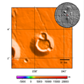
 Ceraunius Fossae, as seen by HiRISE.
 -
 Olympica Fossae, as seen by HiRISE. Click on image to see rock layers in wall.
 -
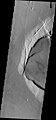
 Trough in Tractus Fossae caused by faults and resulting collapse of material into faults forming a chain of pits, as seen by Mars Global Surveyor.
 -
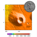
 Tractus Fossae Ringed Pit, as seen by HiRISE. Scale bar is 1000 meters long.


Glaciers
Some scientists see evidence that glaciers exist on many of the volcanoes in Tharsis, including Olympus Mons, Ascraeus Mons, and Pavonis Mons.[19] [20] [21] Ceraunius Tholus may have even had its glaciers melt to form some temporary lakes in the past.[22] [23] [24] [25] [26] [27] [28]
Dark Slope Streaks
Some pictures below show dark streaks: on the slopes on large blocks just to the left of Tharsis Tholus, on Ceraunius Fossae, and on Olympica Fossae. Such streaks are common on Mars. They occur on steep slopes of craters, troughs, and valleys. The streaks are dark at first. They get lighter with age. Sometimes they start in a tiny spot, then spread out and go for hundreds of meters. They have been seen to travel around obstacles, like boulders.[29] It is believed that they are avalanches of bright dust that expose a darker underlying layer. However, several ideas have been advanced to explain them. Some involve water or even the growth of organisms.[30] [31] [32] The streaks appear in areas covered with dust. Much of the Martian surface is covered with dust. Fine dust settles out of the atmosphere covering everything. We know a lot about this dust because the solar panels of the Mars Rovers get covered with dust, thus reducing the electrical energy. The power of the Rovers has been restored many times by the wind, in the form of dust devils, cleaning the panels and boosting the power.[33] Dust storms are frequent, especially when the spring season begins in the southern hemisphere. At that time, Mars is 40% closer to the sun. The orbit of Mars is much more elliptical then the Earth's. That is the difference between the farthest point from the sun and the closest point to the sun is very great for Mars, but only a slight amount for the Earth. Also, every few years, the entire planet is engulfed in global dust storms. When NASA's Mariner 9 craft arrived there, nothing could be seen through the dust storm.[34] [35] Other global dust storms have also been observed, since that time.
-
 Sulci Gordii Terraced Hills, as seen by HiRISE. Many dark slope streaks are visible.
 -
 Ceraunius Tholus Channel, as seen by HiRISE. The summit crater of Ceraunius Tholus is just to the right of this picture. Click on image to see dark slope streaks. The scale bar is 1000 meters long. Straight dark lines are where no data were collected.


Other Features in the Tharsis quadrangle
-
 Tharsis Tholus block, as seen by HiRISE. Block probably tumbled down Tharsis Tholus which is just off to the right.
 -
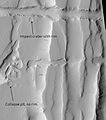
Pangboche Crater, as seen by HiRISE. Pangboche Crater is a very young 11 km diameter crater near the summit of Olympus Mons. Notice the steep walls.
-
 Tractus Catena Floor, as seen by HiRISE. Scale bar is 500 meters long.
 -
Gigas Sulci, as seen by THEMIS. Wavy linear ridges are dunes. Dark Slope Streaks are visible on some slopes if you click on image for larger view.
-
 Lava flows in the Tharsis quadrangle.
 -
 Image shows both young and old lava flows from the base of Olympus Mons. The flat plain is the younger flow. The older flow has channels with levees along their edges. The presence of levees is quite common in many lava flows.


See also
- Climate of Mars
- Water on Mars
- Geology of Mars
- Glacier
- Fossa (geology)
- Dark Slope Streaks
- Volcano
- Tholus
References
External links
- [1] - for Mars animation of how Tharsis evolved.
Vorlage:Mars quadrangle layout
- ↑ Davies, M.E.; Batson, R.M.; Wu, S.S.C. “Geodesy and Cartography” in Kieffer, H.H.; Jakosky, B.M.; Snyder, C.W.; Matthews, M.S., Eds. Mars. University of Arizona Press: Tucson, 1992.
- ↑ Hartmann, W. 2003. A Traveler's Guide to Mars. Workman Publishing. NY NY.
- ↑ ISBN-13 978-0-521-87501-0
- ↑ Norton, O. 2002. Mapping Mars. Picador, New York.
- ↑ ISBN 978-0-521-86698-9
- ↑ Norman H. Sleep: Martian plate tectonics. In: Journal of Geophysical Research. 99. Jahrgang, 1994, S. 5639–5655, doi:10.1029/94JE00216, bibcode:1994JGR....99.5639S.
- ↑ ISBN 978-0-521-85226-5
- ↑ http://dsc.discovery.com/news/2008/12/16/mars-shell-tectonics.html
- ↑ J. E. P. Connerney: From the Cover: Tectonic implications of Mars crustal magnetism. In: Proceedings of the National Academy of Sciences. 102. Jahrgang, 2005, S. 14970–14975, doi:10.1073/pnas.0507469102.
- ↑ Hartmann, W. 2003. A Traveler's Guide to Mars. Workman Publishing. NY NY.
- ↑ Michael H. Carr: The Surface of Mars. Cambridge University Press, 2006, ISBN 978-0-521-87201-0, S. Vorlage:Page needed.
- ↑ Primary centers and secondary concentrations of tectonic activity through time in the western hemisphere of Mars. S. 20563–20585, doi:10.1029/2000JE001278.
- ↑ J. Skinner, L., J. Kargel: Re-assessment of Hydrovolcanism-based Resurfacing within the Galaxias Fossae Region of Mars. In: Lunar and Planetary Science. XXXVIII. Jahrgang, 2007, bibcode:2007LPI....38.1998S (usra.edu [PDF]).
- ↑ http://hirise.lpl.arizona.edu/PSP_008641_2105
- ↑ a b Wyrick, D., D. Ferrill, D. Sims, and S. Colton. 2003. Distribution, Morphology and Structural Associations of Martian Pit Crater Chains. Lunar and Planetary Science XXXIV (2003)
- ↑ http://www.swri.edu/4org/d20/DEMPS/planetgeo/planetmars.html
- ↑ http://www.msss.com/mars_images/moc/2004/01/29/index.html
- ↑ Ferrill, D., D. Wyrick, A. Morris, D. Sims, and N. Franklin. 2004. Dilational fault slip and pit chain foramtion on Mars 14:10:4-12
- ↑ http://www.lpi.edu/meetings/polar2003/pdf/8105.pdf
- ↑ Origin and evolution of cold-based tropical mountain glacier on Mars: the Pavonis Mons fan-shaped deposit. doi:10.1029/2004JR002360.
- ↑ Michael H. Carr: The Surface of Mars. Cambridge University Press, 2006, ISBN 978-0-521-87201-0, S. Vorlage:Page needed.
- ↑ http://www.planetary.brown.edu/pdfs/3408.pdf
- ↑ http://www.mars.asu/christensen/advancedmarsclass/shean_glaciers_2005.pdf
- ↑ JW Head, G Neukum, R Jaumann, H Hiesinger, E Hauber, M Carr, P Masson, B Foing, H Hoffmann: Tropical to mid-latitude snow and ice accumulation, flow and glaciation on Mars. In: Nature. 434. Jahrgang, Nr. 7031, 2005, S. 346–350, doi:10.1038/nature03359, PMID 15772652.
- ↑ http://www.marstoday.com/news/viewpr.html?pid=18050
- ↑ http://news.brown.edu/pressreleases/2008/04/martian-glaciers
- ↑ Jeffrey J. Plaut, Ali Safaeinili, John W. Holt, Roger J. Phillips, James W. Head, Roberto Seu, Nathaniel E. Putzig, Alessandro Frigeri: Radar Evidence for Ice in Lobate Debris Aprons in the Mid-Northern Latitudes of Mars. In: Lunar and Planetary Science. 36. Jahrgang, 2009, doi:10.1029/2008GL036379.
- ↑ Radar Sounding Evidence for Ice within Lobate Debris Aprons near Hellas Basin, Mid-Southern Latitudes of Mars. bibcode:2008LPI....39.2441H (usra.edu [PDF]).
- ↑ http://www.space.com/image_of_day_080730.html
- ↑ http://www.spcae.com/scienceastronomy/streaks_mars_021211.html
- ↑ http://www.space.com/scienceastronomy/streaks_mars_streaks_030328.html
- ↑ www.space.com/scienceastronomy/mars_
- ↑ www.sciencedaily.com/releases/2009/02/090217101110.htm
- ↑ ISBN 0-517-00192-6
- ↑ ISBN 0-8165-1257-4