Datei:Heiltskuk Icefield, British Columbia.JPG
Zur Navigation springen
Zur Suche springen

Größe dieser Vorschau: 800 × 532 Pixel. Weitere Auflösungen: 320 × 213 Pixel | 640 × 425 Pixel | 1.024 × 681 Pixel | 1.280 × 851 Pixel | 2.560 × 1.702 Pixel | 4.256 × 2.829 Pixel
Originaldatei (4.256 × 2.829 Pixel, Dateigröße: 2,43 MB, MIME-Typ: image/jpeg)
![]()
Diese Datei und die Informationen unter dem roten Trennstrich werden aus dem zentralen Medienarchiv Wikimedia Commons eingebunden.
![]()
Beschreibung
| Beschreibung |
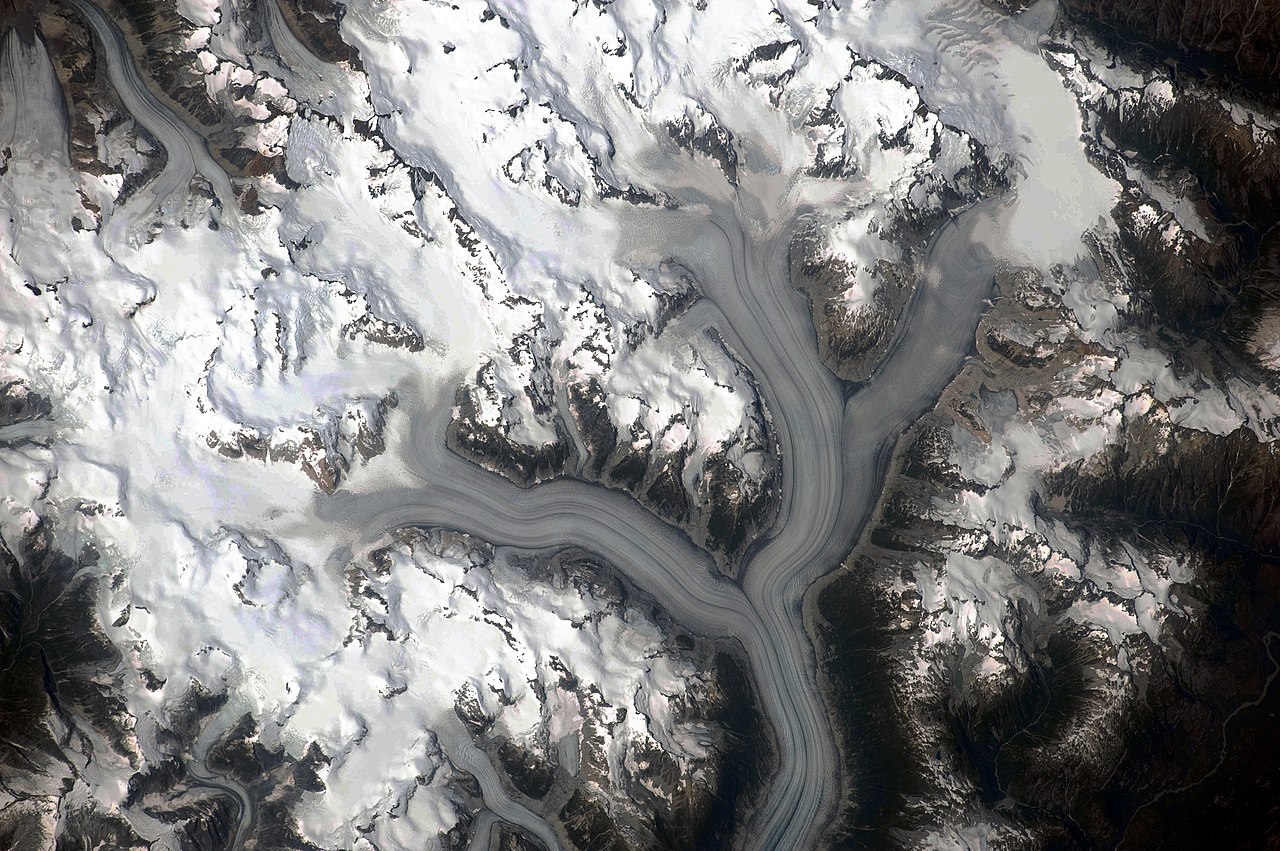
English: This detailed astronaut photograph illustrates the ice-field—mostly covered by snow across the upper mountain slopes—and two major valley glaciers that extend from it. The locations of former valley glaciers can frequently be identified by the presence of these U-shaped valleys on a now glacier-free landscape. The two largest valley glaciers in the image, Silverthrone Glacier and Klinaklini Glacier, both flow towards Knight Inlet to the south (not shown). Several moraines—accumulations of rock and soil debris along the edges and surface of a glacier—are drawn out into long, dark lines by the flowing ice, and they extend along the length of both glaciers. The confluence of the two glaciers at image centre illustrates how a moraine located along the side of a glacier can become a medial moraine, in the centre of the joined ice mass. Smaller valley glaciers are visible near Mount Silverthrone. |
| Datum | |
| Quelle | NASA Earth Observatory |
| Urheber | NASA Expedition 20 crew |
| Kameraposition | | Dieses und weitere Bilder auf OpenStreetMap |
|---|
Diese Mediendatei wurde vom Johnson Space Center der US-amerikanischen National Aeronautics and Space Administration (NASA) unter der Datei-ID ISS020-E-29216 kategorisiert. Diese Markierung zeigt nicht den Urheberrechtsstatus des zugehörigen Werks an. Es ist in jedem Falle zusätzlich eine normale Lizenzvorlage erforderlich. Siehe Commons:Lizenzen für weitere Informationen. Sprachen:
|
Image acquired with a Nikon D3 digital camera fitted with a 400 mm lens, and is provided by the ISS Crew Earth Observations experiment and Image Science & Analysis Laboratory, Johnson Space Center.
Lizenz
| Diese Datei ist gemeinfrei (public domain), da sie von der NASA erstellt worden ist. Die NASA-Urheberrechtsrichtlinie besagt, dass „NASA-Material nicht durch Urheberrecht geschützt ist, wenn es nicht anders angegeben ist“. (NASA-Urheberrechtsrichtlinie-Seite oder JPL Image Use Policy). | ||
 |
Warnung:
|
| Bildnotizen | Diese Datei ist annotiert: Betrachte diese auf Commons. |
Dateiversionen
Klicke auf einen Zeitpunkt, um diese Version zu laden.
| Version vom | Vorschaubild | Maße | Benutzer | Kommentar | |
|---|---|---|---|---|---|
| aktuell | 13:03, 3. Jun. 2010 | | 4.256 × 2.829 (2,43 MB) | Originalwana | {{Information |Description={{en|1=This detailed astronaut photograph illustrates the ice-field—mostly covered by snow across the upper mountain slopes—and two major valley glaciers that extend from it. The locations of former valley glaciers c |
Dateiverwendung
Die folgende Seite verwendet diese Datei:
Globale Dateiverwendung
Die nachfolgenden anderen Wikis verwenden diese Datei:
- Verwendung auf ceb.wikipedia.org
- Verwendung auf en.wikipedia.org
- Verwendung auf en.wikiversity.org
- Verwendung auf fr.wikipedia.org
- Verwendung auf www.wikidata.org