Datei:Louisiade archipelago.jpg
Zur Navigation springen
Zur Suche springen

Größe dieser Vorschau: 800 × 600 Pixel. Weitere Auflösungen: 320 × 240 Pixel | 640 × 480 Pixel | 1.024 × 768 Pixel | 1.280 × 960 Pixel | 2.000 × 1.500 Pixel
Originaldatei (2.000 × 1.500 Pixel, Dateigröße: 449 KB, MIME-Typ: image/jpeg)
![]()
Diese Datei und die Informationen unter dem roten Trennstrich werden aus dem zentralen Medienarchiv Wikimedia Commons eingebunden.
![]()
Beschreibung
| Beschreibung |
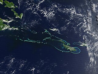
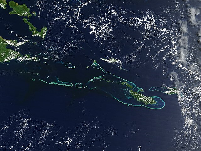
English: Off the southeast tip of Papua New Guinea lies a string of small volcanic islands and coral reefs collectively called the Louisiade Archipelago. This true-color MODIS image from September 11, 2002, is centered on the island chain, with Papua New Guinea at the left edge. Moving westward from eastern end of the chain are the islands of Rossel and Tagula. (Misima Island, which harbors the largest village in the region, is obscured by a patch of clouds northeast of image center.) To the north of the chain lies the Solomon Sea, and to the south is the Coral Sea. Most of the undisturbed land is covered by tropical rainforest, and despite their small size, the islands harbor a number of plant and animal species found nowhere else. |
| Datum | 7. Mai 2005 (Original-Hochladedatum) |
| Quelle | Transferred from en.wikipedia |
| Urheber | NASA |
Lizenz
| Diese Datei ist gemeinfrei (public domain), da sie von der NASA erstellt worden ist. Die NASA-Urheberrechtsrichtlinie besagt, dass „NASA-Material nicht durch Urheberrecht geschützt ist, wenn es nicht anders angegeben ist“. (NASA-Urheberrechtsrichtlinie-Seite oder JPL Image Use Policy). | ||
 |
Warnung:
|
Ursprüngliches Datei-Logbuch
All following user names refer to en.wikipedia.
- 2005-05-07 02:55 PDH 2000×1500× (459961 bytes) Off the southeast tip of Papua New Guinea lies a string of small volcanic islands and coral reefs collectively called the Louisiade Archipelago. This true-color MODIS image from September 11, 2002, is centered on the island chain, with Papua New Guinea at
Dateiversionen
Klicke auf einen Zeitpunkt, um diese Version zu laden.
| Version vom | Vorschaubild | Maße | Benutzer | Kommentar | |
|---|---|---|---|---|---|
| aktuell | 10:55, 18. Okt. 2009 | | 2.000 × 1.500 (449 KB) | Urdangaray | {{Information |Description={{en|Off the southeast tip of Papua New Guinea lies a string of small volcanic islands and coral reefs collectively called the Louisiade Archipelago. This true-color MODIS image from September 11, 2002, is centered on the island |
Dateiverwendung
Die folgende Seite verwendet diese Datei:
Globale Dateiverwendung
Die nachfolgenden anderen Wikis verwenden diese Datei:
- Verwendung auf als.wikipedia.org
- Verwendung auf ast.wikipedia.org
- Verwendung auf br.wikipedia.org
- Verwendung auf ca.wikipedia.org
- Verwendung auf ceb.wikipedia.org
- Verwendung auf en.wikipedia.org
- Verwendung auf en.wikivoyage.org
- Verwendung auf eo.wikipedia.org
- Verwendung auf es.wikipedia.org
- Verwendung auf eu.wikipedia.org
- Verwendung auf he.wikivoyage.org
- Verwendung auf hy.wikipedia.org
- Verwendung auf it.wikipedia.org
- Verwendung auf it.wikivoyage.org
- Verwendung auf ka.wikipedia.org
- Verwendung auf la.wikipedia.org
- Verwendung auf or.wikipedia.org
- Verwendung auf pl.wikipedia.org
- Verwendung auf vi.wikipedia.org
- Verwendung auf www.wikidata.org