Datei:Qaidam-basin-china.jpg
Zur Navigation springen
Zur Suche springen

Größe dieser Vorschau: 600 × 600 Pixel. Weitere Auflösungen: 240 × 240 Pixel | 480 × 480 Pixel | 768 × 768 Pixel | 1.024 × 1.024 Pixel | 1.280 × 1.280 Pixel
Originaldatei (1.280 × 1.280 Pixel, Dateigröße: 1,16 MB, MIME-Typ: image/jpeg)
![]()
Diese Datei und die Informationen unter dem roten Trennstrich werden aus dem zentralen Medienarchiv Wikimedia Commons eingebunden.
![]()
Beschreibung
| Beschreibung |
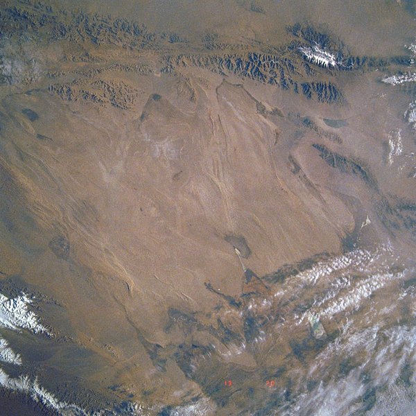
Deutsch: STS040-613-011 Qaidambecken, China, Juni 1991
English: Image Caption: STS040-613-011 Qaidam Basin, China June 1991
This mostly east-looking view [here rotated to place north at the top] shows the Qaidam Basin. Located in the Northern Tibetan Plateau, the Qaidam Basin sets between two branches of the Kunlun Mountains. To the north (left edge) are the Altun Mountains and to the south (right edge) are the Qimantag Mountains. The arid basin is 350 miles (560 km) long and 100 miles (160 km) wide. A salt marsh occupies most of the basin. Oil fields and refineries are located in the west part (bottom center) of the basin. Iron ore is mined in the southern part of the basin. Coal deposits have been found in the Qaidam Basin. Cooler climate crops such as wheat, highland barley, millet, and potatoes are grown during the short, cool summer months. Español: STS040-613-011 Cuenca de Qaidam, China, Junio de 1991 |
||||
| Datum | |||||
| Quelle |
https://eol.jsc.nasa.gov/SearchPhotos/photo.pl?mission=STS040&roll=613&frame=11 (original uploader information: http://eol.jsc.nasa.gov/sseop/efs/lores.pl?PHOTO=STS040-613-11) |
||||
| Urheber | NASA | ||||
| Photo center point |
|
Lizenz
| Diese Datei ist gemeinfrei (public domain), da sie von der NASA erstellt worden ist. Die NASA-Urheberrechtsrichtlinie besagt, dass „NASA-Material nicht durch Urheberrecht geschützt ist, wenn es nicht anders angegeben ist“. (NASA-Urheberrechtsrichtlinie-Seite oder JPL Image Use Policy). | ||
 |
Warnung:
|
Ursprüngliches Datei-Logbuch
Übertragen aus en.wikipedia nach Commons durch Quadell mithilfe des CommonsHelper.
Die ursprüngliche Dateibeschreibungsseite war hier. Alle folgenden Benutzernamen beziehen sich auf en.wikipedia.
- 2008-02-06 02:49 Mattisse 640×640× (385252 bytes) {{Information |Description=Quaidam Basin, China |Source=http://eol.jsc.nasa.gov/sseop/efs/lores.pl?PHOTO=STS040-613-11 |Date=2008-02-05 |Location=Quaidam Basin, China |Author=NASA |Permission= |other_versions= }}
| Bildnotizen | Diese Datei ist annotiert: Betrachte diese auf Commons. |
Dateiversionen
Klicke auf einen Zeitpunkt, um diese Version zu laden.
| Version vom | Vorschaubild | Maße | Benutzer | Kommentar | |
|---|---|---|---|---|---|
| aktuell | 10:18, 7. Aug. 2019 | | 1.280 × 1.280 (1,16 MB) | LlywelynII | Reverted to version as of 08:17, 7 August 2019 (UTC) STOP ROTATING THIS |
| 10:18, 7. Aug. 2019 |  | 640 × 640 (404 KB) | LlywelynII | Reverted to version as of 08:12, 7 August 2019 (UTC) testing | |
| 10:17, 7. Aug. 2019 |  | 1.280 × 1.280 (1,16 MB) | LlywelynII | let's try this again... | |
| 10:12, 7. Aug. 2019 |  | 640 × 640 (404 KB) | LlywelynII | North at top | |
| 21:34, 7. Sep. 2011 |  | 640 × 640 (376 KB) | File Upload Bot (Magnus Manske) | {{BotMoveToCommons|en.wikipedia|year={{subst:CURRENTYEAR}}|month={{subst:CURRENTMONTHNAME}}|day={{subst:CURRENTDAY}}}} {{Information |Description={{en|Qaidam Basin, China}} |Source=Transferred from [http://en.wikipedia.org en.wikipedia]; transferred to C |
Dateiverwendung
Die folgende Seite verwendet diese Datei:
Globale Dateiverwendung
Die nachfolgenden anderen Wikis verwenden diese Datei:
- Verwendung auf az.wikipedia.org
- Verwendung auf en.wikipedia.org
- Verwendung auf es.wikipedia.org
- Verwendung auf hy.wikipedia.org
- Verwendung auf id.wikipedia.org
- Verwendung auf no.wikipedia.org
- Verwendung auf ru.wikipedia.org
- Verwendung auf sl.wikipedia.org
- Verwendung auf sr.wikipedia.org
- Verwendung auf sv.wikipedia.org
- Verwendung auf tr.wikipedia.org
- Verwendung auf vi.wikipedia.org
- Verwendung auf zh-yue.wikipedia.org