Category:Landwirtschaftliche Lehranstalt Rotholz
Jump to navigation
Jump to search
| Object location | | View all coordinates using: OpenStreetMap |
|---|
museum in Austria, former a Castle of the graves of Tyrol  | |||||
| Upload media | |||||
| Instance of | |||||
|---|---|---|---|---|---|
| Location | Strass im Zillertal, Schwaz District, Tyrol, Austria | ||||
| Street address |
| ||||
| Operator | |||||
| Heritage designation | |||||
| Inception |
| ||||
| official website | |||||
 | |||||
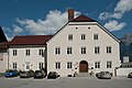
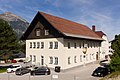
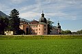
Deutsch: Die Landwirtschaftliche Landeslehranstalt Rotholz im Schloss Rotholz befindet sich in der Gemeinde Strass im Zillertal.
Media in category "Landwirtschaftliche Lehranstalt Rotholz"
The following 24 files are in this category, out of 24 total.
-
 Die Gartenlaube (1874) b 683 1.jpg 1,736 × 1,440; 901 KB
-
 Landwirtschaftliche Lehranstalt Rotholz 10.jpg 3,670 × 2,456; 5.74 MB
-
 Landwirtschaftliche Lehranstalt Rotholz 11.jpg 2,474 × 3,696; 5.44 MB
-
 Landwirtschaftliche Lehranstalt Rotholz 12.jpg 3,709 × 2,483; 5.61 MB
-
 Landwirtschaftliche Lehranstalt Rotholz 13.jpg 3,793 × 2,539; 5.78 MB
-
 Landwirtschaftliche Lehranstalt Rotholz 14.jpg 3,872 × 2,592; 7.31 MB
-
 Landwirtschaftliche Lehranstalt Rotholz 15.jpg 3,774 × 2,527; 5.28 MB
-
 Landwirtschaftliche Lehranstalt Rotholz 2.jpg 3,598 × 2,436; 3.99 MB
-
 Landwirtschaftliche Lehranstalt Rotholz 3.jpg 3,793 × 2,539; 5.57 MB
-
 Landwirtschaftliche Lehranstalt Rotholz 4.jpg 3,872 × 2,592; 5.63 MB
-
 Landwirtschaftliche Lehranstalt Rotholz 5.jpg 3,616 × 2,421; 4.75 MB
-
 Landwirtschaftliche Lehranstalt Rotholz 6.jpg 2,592 × 3,872; 6.07 MB
-
 Landwirtschaftliche Lehranstalt Rotholz 7.jpg 3,694 × 2,473; 5.36 MB
-
 Landwirtschaftliche Lehranstalt Rotholz 8.jpg 3,872 × 2,592; 5.27 MB
-
 Landwirtschaftliche Lehranstalt Rotholz 9.jpg 3,780 × 2,531; 4.41 MB
-
 Landwirtschaftliche Lehranstalt Rotholz1.jpg 3,670 × 2,457; 4.1 MB
-
 Pavillion nahe der LandwirtschaftlichenLehranstalt Rotholz. 11.09.2018.jpg 3,456 × 5,184; 11.63 MB
-
 Rotholz 50, 11.08.2018.jpg 5,184 × 3,456; 10.57 MB
-
 Schloss Rotholz in Strass im Zillertal 1.JPG 4,151 × 2,757; 2.81 MB
-
 Schloss Rotholz in Strass im Zillertal 2.JPG 4,157 × 2,761; 3.47 MB
-
 T-Rotholz-Lehranstalt-1.jpg 2,511 × 1,674; 1.11 MB
-
 T-Rotholz-Lehranstalt-2.jpg 1,856 × 2,475; 1.21 MB
-
 T-Rotholz-Schloss-1.jpg 3,648 × 2,432; 1.66 MB
-
 T-Rotholz-Schloss-2.jpg 4,460 × 2,448; 1.99 MB
_b_683_1.jpg)


