Datei:1921 Railway terminal map of Chicago by Rand McNally.jpg

Originaldatei (2.800 × 3.765 Pixel, Dateigröße: 8,15 MB, MIME-Typ: image/jpeg)
![]()
Diese Datei und die Informationen unter dem roten Trennstrich werden aus dem zentralen Medienarchiv Wikimedia Commons eingebunden.
![]()
| Titel |
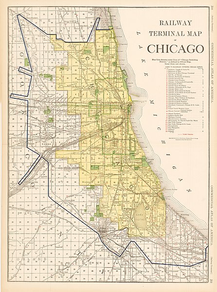
Railway Terminal Map of Chicago |
||||
| Beschreibung |
This antique railway map of Chicago was published in the 1921 Edition of Rand McNally’s Indexed Atlas of the World. It is a very detailed representation of Chicago which includes more than just the rail lines that run through the city. The names of the various Chicago neighborhoods and suburbs are noted, as well as prominent streets and landmarks. |
||||
| Datum | |||||
| Quelle | HJB Maps | ||||
| Urheber |
Rand McNally |
||||
| Genehmigung (Weiternutzung dieser Datei) |
|
||||
| Kartografische Angaben | |||||
| Abgebildetes Datum | |||||
| Ortsbezug | Chicago | ||||
| Georeferenzierung | If inappropriate please set warp_status = skip to hide. | ||||
| Bibliographische Angaben | |||||
| Verleger |
Rand McNally |
||||
| Archivalische Angaben | |||||
| Maße | Höhe: 26 in (66 cm); Breite: 19 in (48,2 cm) | ||||
Dateiversionen
Klicke auf einen Zeitpunkt, um diese Version zu laden.
| Version vom | Vorschaubild | Maße | Benutzer | Kommentar | |
|---|---|---|---|---|---|
| aktuell | 00:11, 16. Aug. 2016 | | 2.800 × 3.765 (8,15 MB) | Scewing | {{Map |title =Railway Terminal Map of Chicago |description =This antique railway map of Chicago was published in the 1921 Edition of Rand McNally’s Indexed Atlas of the World. It is a very detailed representation of Chicago which in... |
Dateiverwendung
Die folgende Seite verwendet diese Datei: