Datei:1950s CIA map of Iraq – tribes of Iraq.jpg
Zur Navigation springen
Zur Suche springen
Größe dieser Vorschau: 684 × 599 Pixel. Weitere Auflösungen: 274 × 240 Pixel | 548 × 480 Pixel | 876 × 768 Pixel | 1.169 × 1.024 Pixel | 2.337 × 2.048 Pixel | 6.510 × 5.705 Pixel
Originaldatei (6.510 × 5.705 Pixel, Dateigröße: 3,62 MB, MIME-Typ: image/jpeg)
![]()
Diese Datei und die Informationen unter dem roten Trennstrich werden aus dem zentralen Medienarchiv Wikimedia Commons eingebunden.
![]()
Beschreibung
| Beschreibung |
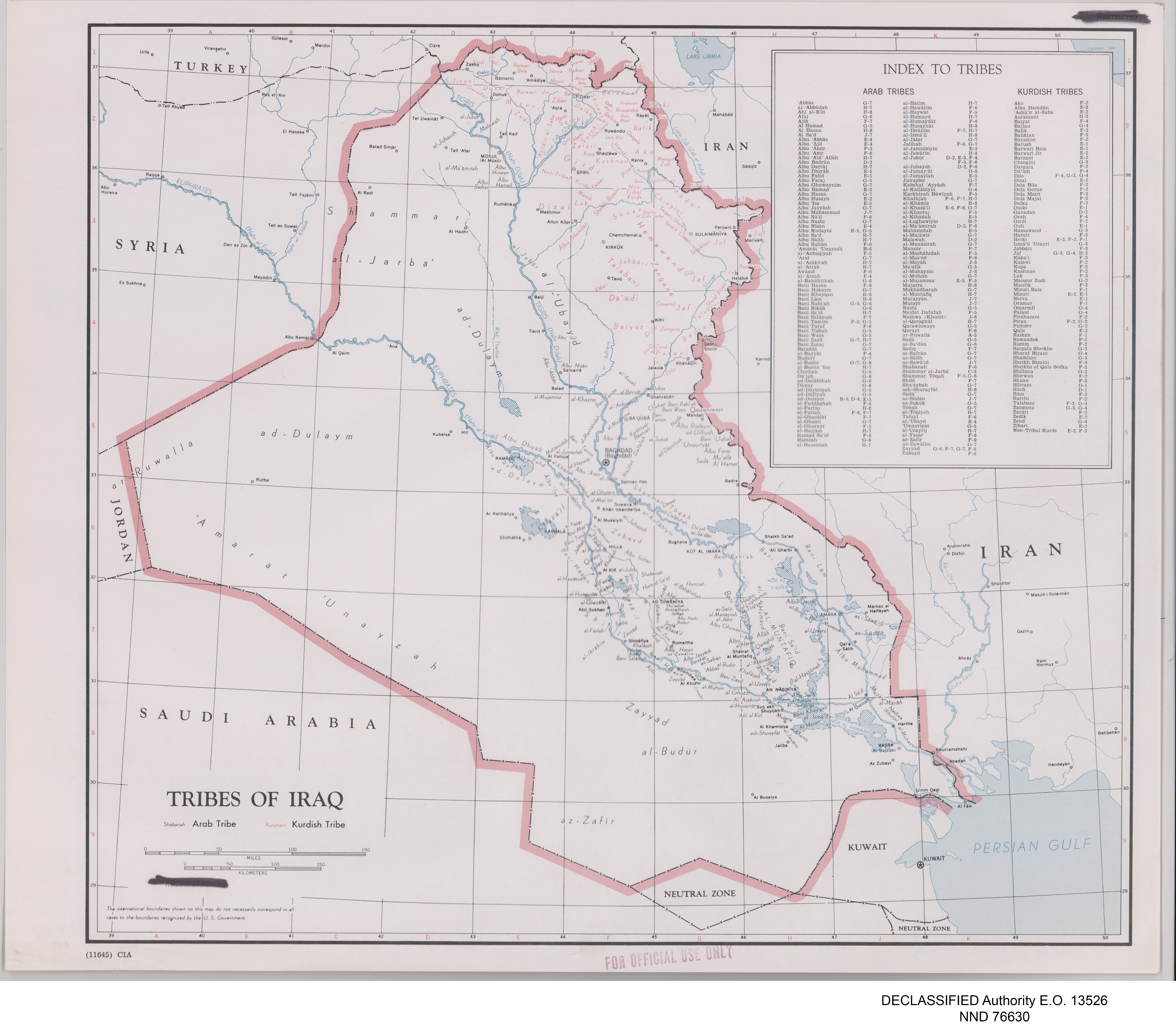
English: Map of Iraq prepared by the United States Central Intelligence Agency's Map Branch circa 1950. Names of Arab tribes are written in black; names of Kurdish tribes are in green. An "Index of Tribes is in the top right, with Arab and Kurdish tribes arranged in columns. Marked at bottom left: "11645", and top right: "RESTRICTED" (struck through). Stamped "FOR OFFICIAL USE ONLY" in red, bottom centre. In the map area itself, the word "RESTRICTED" in red has been deleted at the bottom left, beneath which is printed: "The international boundaries shown on this map do not necessarily correspond in all cases to the boundaries recognized by the U.S. Government." Digitally added to the image, beneath the map: "DECLASSIFIED Authority E.O. 13526" and "NND 76630". |
| Datum | |
| Quelle |
United States National Archives Published Maps, 1947–2015 Record Group 263: Records of the Central Intelligence Agency, 1894–2002 https://catalog.archives.gov/id/175514185 (National Archives Identifier: 175514185) |
| Urheber | Map Service Center, Central Intelligence Agency, United States National Security Council |
| Andere Versionen |
.jpg)
.jpg)
Lizenz
| Dieses Bild ist eine Arbeit eines CIA-Mitarbeiters. Als ein Werk der Regierung der Vereinigten Staaten ist dieses Bild in den USA gemeinfrei.
|

|
Dateiversionen
Klicke auf einen Zeitpunkt, um diese Version zu laden.
| Version vom | Vorschaubild | Maße | Benutzer | Kommentar | |
|---|---|---|---|---|---|
| aktuell | 06:32, 24. Mai 2021 | | 6.510 × 5.705 (3,62 MB) | GPinkerton | Uploaded a work by Map Service Center, Central Intelligence Agency, United States National Security Council from United States National Archives Published Maps, 1947–2015 Record Group 263: Records of the Central Intelligence Agency, 1894–2002 https://catalog.archives.gov/id/175514185 (National Archives Identifier: 175514185) with UploadWizard |
Dateiverwendung
Keine Seiten verwenden diese Datei.