Datei:2018-03-06-0627z NOAA-20 dnb Riley-II (Yuliya).png
Originaldatei (1.920 × 1.080 Pixel, Dateigröße: 2,45 MB, MIME-Typ: image/png)
![]()
Diese Datei und die Informationen unter dem roten Trennstrich werden aus dem zentralen Medienarchiv Wikimedia Commons eingebunden.
![]()
.png?uselang=de)
Beschreibung
| Beschreibung |
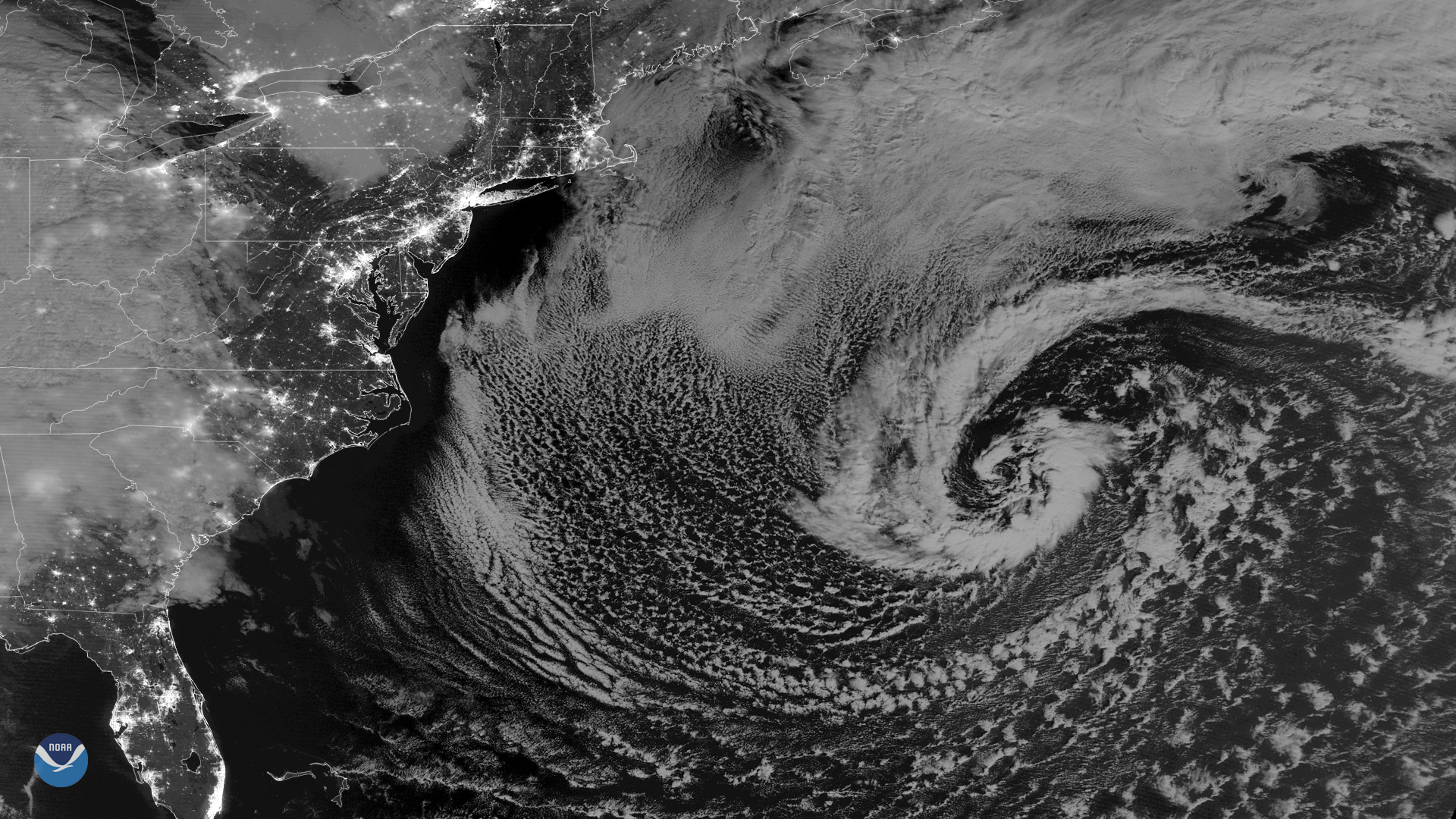
English: The NOAA-20 polar-orbiting satellite captured this nighttime image of a strong secondary low pressure system in the western Atlantic Ocean at 0627 UTC on March 6, 2018. While not a threat to land, the storm developed in the wake of last week's powerful nor'easter that battered the Mid-Atlantic and New England. NOAA's Ocean Prediction Center reported gale-force winds and hazardous marine conditions in the western Atlantic, about 500 miles off the coast of the Carolinas.
This imagery is from the day-night band of the NOAA-20 satellite's Visible Infrared Imaging Radiometer Suite, or VIIRS sensor. Clear skies over the East Coast reveal the nighttime lights of the Northeast Corridor – from Washington, D.C. to Boston – in remarkable detail. NOAA-20's VIIRS sensor is sensitive enough to detect the nocturnal glow produced by Earth's atmosphere and the light from a single ship in the sea.Deutsch: Der Satellit NOAA-20 nahm am 6. März 2018 um 06:27 Uhr UTC dieses Nachtbild eines starken sekundären Tiefdruckgebietes im westlichen Atlantischen Ozean auf. Der Sturm ist zwar keine Gefahr für das Festland der Vereinigten Staaten, entwickelte sich allerdings auf den Spuren des kräftigen Nor'easters, der Anfang März die Mittelatlantikstaaten und Neuengland gebeutelt hat. Das Ocean Prediction Center derNOAA meldete sturmartige Winde und gefährliche Seebedingungen im westlichen Atlantik, etwa 800 km vor der Küste der Carolinastaaten.
Dieses Bild vom Tag-Nacht-Band der Visible Infrared Imaging Radiometer Suite oder auch VIIRS-Sensor des NOAA-20-Satelliten. Durch den klaren Himel über der Ostküste der Vereinigten Staaten sind die nächtlichen Beleuchtungen des Northeast Corridor von Washington, D.C. bis nach Boston bemerkenswert detailliert erkennbar. Der VIIRS-Sensor auf dem NOAA-20-Satelliten ist empfindlich genug, um das nächtliche Glimmern der Erdatmosphäre und das Licht eines einzelnen Schiffes auf dem Meer aufzuzeichnen. |
| Datum | |
| Quelle | https://www.nesdis.noaa.gov/content/nighttime-view-another-storm-us-east-coast |
| Urheber | NOAA Environmental Visualization Laboratory via NOAA National Environmental Satellite, Data, and Information Service (NESDIS) |
Lizenz
Diese Datei ist gemeinfrei (public domain), weil sie Material enthält, das von einem Angestellten der National Oceanic and Atmospheric Administration im Verlaufe seiner offiziellen Arbeit erstellt wurde.
|
Dateiversionen
Klicke auf einen Zeitpunkt, um diese Version zu laden.
| Version vom | Vorschaubild | Maße | Benutzer | Kommentar | |
|---|---|---|---|---|---|
| aktuell | 02:05, 7. Mär. 2018 | | 1.920 × 1.080 (2,45 MB) | Matthiasb | {{Information |description ={{en|1= The NOAA-20 polar-orbiting satellite captured this nighttime image of a strong secondary low pressure system in the western Atlantic Ocean at 0627 UTC on March 6, 2018. While not a threat to land, the storm developed in the wake of last week's powerful nor'easter that battered the Mid-Atlantic and New England. NOAA's Ocean Prediction Center reported gale-force winds and hazardous marine conditions in the western Atlantic, about 500 miles off the coast of the Carolinas. This imagery is from the day-night band of the NOAA-20 satellite's Visible Infrared Imaging Radiometer Suite, or VIIRS sensor. Clear skies over the East Coast reveal the nighttime lights of the Northeast Corridor – from Washington, D.C. to Boston – in remarkable detail. NOAA-20's VIIRS sensor is sensitive enough to detect the nocturnal glow produced by Earth's atmosphere and the light from a single ship in the sea. }} {{de|1=Der Satellit NOAA-20 nahm am 6. März 2018 um 06:27&nb... |
Dateiverwendung
Die folgende Seite verwendet diese Datei:
.png)