Datei:2021 NHC AL122021 5day cone no line and wind.png
Zur Navigation springen
Zur Suche springen

Größe dieser Vorschau: 731 × 600 Pixel. Weitere Auflösungen: 293 × 240 Pixel | 585 × 480 Pixel | 897 × 736 Pixel
Originaldatei (897 × 736 Pixel, Dateigröße: 95 KB, MIME-Typ: image/png)
![]()
Diese Datei und die Informationen unter dem roten Trennstrich werden aus dem zentralen Medienarchiv Wikimedia Commons eingebunden.
![]()
Beschreibung
| Beschreibung |
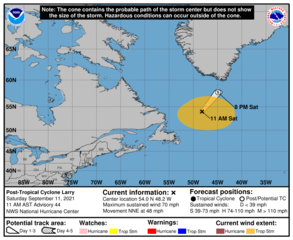
English: National Hurricane Center's 5-day track and intensity forecast cone of Atlantic AL122021 Post-Tropical Cyclone Larry. |
| Datum | |
| Quelle | https://www.nhc.noaa.gov/refresh/graphics_at2+shtml/143911.shtml?cone#contents |
| Urheber | National Hurricane Center |
Lizenz
Diese Datei ist gemeinfrei (public domain), weil sie Material enthält, das von einem Angestellten der National Oceanic and Atmospheric Administration im Verlaufe seiner offiziellen Arbeit erstellt wurde.
|
Dateiversionen
Klicke auf einen Zeitpunkt, um diese Version zu laden.
| Version vom | Vorschaubild | Maße | Benutzer | Kommentar | |
|---|---|---|---|---|---|
| aktuell | 17:05, 11. Sep. 2021 | | 897 × 736 (95 KB) | Cewbot | Import NHC tropical cyclone forecast map of Atlantic AL122021 Post-Tropical Cyclone Larry Location: 54.0°N 48.2°W. Moving: NNE at 48 mph. Min pressure: 963 mb. Max sustained: 70 mph. https://www.nhc.noaa.gov/storm_graphics/AT12/refresh/AL122021_5day_cone_no_line_and_wind+png/143911_5day_cone_no_line_and_wind.png (2021-09-11 12:00 UTC) |
| 11:05, 11. Sep. 2021 |  | 897 × 736 (90 KB) | Cewbot | Import NHC tropical cyclone forecast map of Atlantic AL122021 Hurricane Larry Location: 50.7°N 51.7°W. Moving: NNE at 48 mph. Min pressure: 966 mb. Max sustained: 75 mph. https://www.nhc.noaa.gov/storm_graphics/AT12/refresh/AL122021_5day_cone_no_line_and_wind+png/083220_5day_cone_no_line_and_wind.png (2021-09-11 06:00 UTC) | |
| 08:05, 11. Sep. 2021 |  | 897 × 736 (98 KB) | Cewbot | Import NHC tropical cyclone forecast map of Atlantic AL122021 Hurricane Larry Location: 48.7°N 53.2°W. Moving: NNE at 47 mph. Min pressure: 963 mb. Max sustained: 80 mph. https://www.nhc.noaa.gov/storm_graphics/AT12/refresh/AL122021_5day_cone_no_line_and_wind+png/054133_5day_cone_no_line_and_wind.png (2021-09-11 06:00 UTC) | |
| 05:06, 11. Sep. 2021 |  | 897 × 736 (93 KB) | Cewbot | Import NHC tropical cyclone forecast map of Atlantic AL122021 Hurricane Larry Location: 46.8°N 54.9°W. Moving: NNE at 47 mph. Min pressure: 958 mb. Max sustained: 80 mph. https://www.nhc.noaa.gov/storm_graphics/AT12/refresh/AL122021_5day_cone_no_line_and_wind+png/025009_5day_cone_no_line_and_wind.png (2021-09-11 00:00 UTC) | |
| 02:05, 11. Sep. 2021 |  | 897 × 736 (99 KB) | Cewbot | Import NHC tropical cyclone forecast map of Atlantic AL122021 Hurricane Larry Location: 44.9°N 56.5°W. Moving: NNE at 35 mph. Min pressure: 958 mb. Max sustained: 80 mph. https://www.nhc.noaa.gov/storm_graphics/AT12/refresh/AL122021_5day_cone_no_line_and_wind+png/234554_5day_cone_no_line_and_wind.png (2021-09-11 00:00 UTC) | |
| 23:05, 10. Sep. 2021 |  | 897 × 736 (99 KB) | Cewbot | Import NHC tropical cyclone forecast map of Atlantic AL122021 Hurricane Larry Location: 43.5°N 58.2°W. Moving: NNE at 35 mph. Min pressure: 967 mb. Max sustained: 80 mph. https://www.nhc.noaa.gov/storm_graphics/AT12/refresh/AL122021_5day_cone_no_line_and_wind+png/204510_5day_cone_no_line_and_wind.png (2021-09-10 18:00 UTC) | |
| 20:05, 10. Sep. 2021 |  | 897 × 736 (98 KB) | Cewbot | Import NHC tropical cyclone forecast map of Atlantic AL122021 Hurricane Larry Location: 41.8°N 59.5°W. Moving: NNE at 29 mph. Min pressure: 971 mb. Max sustained: 80 mph. https://www.nhc.noaa.gov/storm_graphics/AT12/refresh/AL122021_5day_cone_no_line_and_wind+png/175212_5day_cone_no_line_and_wind.png (2021-09-10 18:00 UTC) | |
| 17:06, 10. Sep. 2021 |  | 897 × 736 (101 KB) | Cewbot | Import NHC tropical cyclone forecast map of Atlantic AL122021 Hurricane Larry Location: 40.0°N 60.5°W. Moving: NNE at 29 mph. Min pressure: 971 mb. Max sustained: 80 mph. https://www.nhc.noaa.gov/storm_graphics/AT12/refresh/AL122021_5day_cone_no_line_and_wind+png/145003_5day_cone_no_line_and_wind.png (2021-09-10 12:00 UTC) | |
| 14:06, 10. Sep. 2021 |  | 897 × 736 (98 KB) | Cewbot | Import NHC tropical cyclone forecast map of Atlantic AL122021 Hurricane Larry Location: 39.2°N 60.8°W. Moving: NNE at 26 mph. Min pressure: 968 mb. Max sustained: 85 mph. https://www.nhc.noaa.gov/storm_graphics/AT12/refresh/AL122021_5day_cone_no_line_and_wind+png/115447_5day_cone_no_line_and_wind.png (2021-09-10 12:00 UTC) | |
| 11:05, 10. Sep. 2021 |  | 897 × 736 (100 KB) | Cewbot | Import NHC tropical cyclone forecast map of Atlantic AL122021 Hurricane Larry Location: 37.7°N 61.8°W. Moving: NNE at 26 mph. Min pressure: 968 mb. Max sustained: 85 mph. https://www.nhc.noaa.gov/storm_graphics/AT12/refresh/AL122021_5day_cone_no_line_and_wind+png/084510_5day_cone_no_line_and_wind.png (2021-09-10 06:00 UTC) |
Dateiverwendung
Keine Seiten verwenden diese Datei.
Globale Dateiverwendung
Die nachfolgenden anderen Wikis verwenden diese Datei:
- Verwendung auf en.wikipedia.org