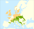
| Quelle |
Caudullo, G., Welk, E., San-Miguel-Ayanz, J., 2017. Chorological maps for the main European woody species. Data in Brief 12, 662-666. DOI: 10.1016/j.dib.2017.05.007
Data: https://doi.org/10.6084/m9.figshare.4758208
References:
- Alía Miranda, R., García del Barrio, J. M., Iglesias Sauce, S., Mancha Núñez, J. A., de Miguel y del Ángel, J., Nicolás Peragón, J. L., Pérez Martín, F., Sánchez de Ron, D., 2009. Regiones de procedencia de especies forestales en España. Organismo Autónomo Parques Nacionales, Madrid.
- Ambrosio, E., Brotzu, R., Lancellotti, E., Franceschini, A., Zotti, M., 2014. Macrofungi in Abies alba Miller plantation in north-western Sardinia, Italy. Micologia Italiana, 43(1-2-3): 3-24.
- Assyov, B., Petrova, A. (Eds.), 2012. Conspectus Of The Bulgarian Vascular Flora. 4th Edition. Bulgarian Biodiversity Foundation, Sofia. ISBN 9789549959581
- Biodiversity Research Center - Institute of Botany. Flora Database of the Czech Republic. Accessed in September 2016.
- Bohn, U., Gollub, G., Hettwer, C., Weber, H., Neuhäuslová, Z., Raus, T., Schlüter, H., 2000. Karte der natürlichen Vegetation Europas; Map of the Natural Vegetation of Europe. Landwirtschaftsverlag. ISBN 9783784338095
- Botanical Society of Britain & Ireland. BSBI big database. Accessed in September 2016.
- Cambria, S. Flora e vegetazione della Sicilia. Accessed in February 2017.
- Conservatoire et Jardin botaniques de la Ville de Genève (CJB), Pro Natura, Société Botanique Suisse, Académie Suisse des Sciences Naturelles. Info Flora. Accessed in September 2016.
- EUFORGEN, 2009. Distribution map of Silver fir (Abies alba). www.euforgen.org
- European Information System on Forest Genetic Resources. EUFGIS database. Accessed in September 2016
- Farjon, A., 2016. Conifer of the world. Online Database, Department of Plant Sciences, University of Oxford. Accessed in September 2016.
- García del Barrio, J. M., Auñón F. J., Sanchez de Ron, D. SIG-FOREST, Sistema de Información de Especies Forestales. Accessed in February 2017
- GBIF.org, 2016. Artdata. DOI: 10.15468/dl.vhlsf9
- GBIF.org, 2017. Biologiezentrum Linz. DOI: 10.15468/dl.zcfnm9
- GBIF.org, 2016. Botanical Society of the British Isles - Vascular Plants Database additions since 2000. DOI: 10.15468/dl.wzy04e
- GBIF.org, 2016. Botanical Society of the British Isles - Vascular Plants Database. DOI: 10.15468/dl.c7xheb
- GBIF.org, 2016. Dutch Vegetation Database (LVD). DOI: 10.15468/dl.km20zh
- GBIF.org, 2016. FloVegSI - Floristical and fitocenological database of ZRC SAZU. DOI: 10.15468/dl.emozjq
- GBIF.org, 2016. Flora von Deutschland (Phanerogamen). DOI: 10.15468/dl.jhwqco
- GBIF.org, 2016. FloraCAT: Banco de datos de los cormófitos de Cataluña. DOI: 10.15468/dl.biuda7
- GBIF.org, 2016. Florabank1 - A grid-based database on vascular plant distribution in the northern part of Belgium (Flanders and the Brussels Capital region). DOI: 10.15468/dl.t9ewq8
- GBIF.org, 2016. Floristic Databases of Mecklenburg-Pomerania - Higher Plants. DOI: 10.15468/dl.ttbnoc
- GBIF.org, 2016. Fundación Biodiversidad, Real Jardín Botánico (CSIC): Anthos. Sistema de Información de las plantas de España. DOI: 10.15468/dl.9uo7is
- GBIF.org, 2016. INPN - Données flore des CBN agrégées par la FCBN. DOI: 10.15468/dl.gkp7wm
- GBIF.org, 2016. Institute of Dendrology PAS, Flora of Sudety Mountains. DOI: .15468/dl.kybkpr
- GBIF.org, 2016. Karl Franzens University of Graz, Insitute for Botany - Herbarium GZU. DOI: 10.15468/dl.4ok78i
- GBIF.org, 2016. National System of Protected Areas in Poland - Plants. DOI: 10.15468/dl.ym4vmn
- GBIF.org, 2016. Norwegian Species Observation Service. DOI: 10.15468/dl.6domy8
- GBIF.org, 2016. Occurrence Data of Vascular Plants collected or compiled for the Flora of Bavaria. DOI: 10.15468/dl.olxxvo
- GBIF.org, 2016. Sistema de Información de la vegetación Ibérica y Macaronésica. DOI: 10.15468/dl.m8zdd8
- GBIF.org, 2016. Vascular plants in Denmark recorded under the The Nationwide Monitoring and Assessment Programme for the Aquatic and Terrestrial Environments (NOVANA). DOI: 10.15468/dl.hnqokh
- ICP Forests, 2017. Forest Monitoring Information System: online database. Accessed in November 2017
- Jalas, J., Suominen, J., 1973. Atlas Florae Europaeae: distribution of vascular plants in Europe Vol. 2 Gymnospermae (Pinaceae to Ephedraceae). Committee for Mapping the Flora of Europe and Societas Biologica Fennica Vanamo, Helsinki.
- Marques, H., Pinto, G., Pinto, P., Teixeira, C., 2012. Regiões de Proveniência, Portugal. Autoridade Florestal Nacional, Lisboa.
- Mauri, A., Strona, G., San-Miguel-Ayanz, J., 2017. EU-Forest, a high-resolution tree occurrence dataset for Europe. Scientific Data 4: 160123. DOI: 10.1038/sdata.2016.123
- Meusel, H., Jäger, E. J., Weinert, E. (Eds.), 1965. Vergleichende Chorologie der Zentraleuropäischen Flora, Band I. Gustav Fischer Verlag, Jena.
- NetPhyD: Deutschlandflora WebGIS. Floristische Verbreitungskarten in Deutschland. Accessed in September 2016.
- Nikolić, T. (Ed.), 2015. Flora Croatica Database. Faculty of Science, University of Zagreb. Accessed in September 2016.
- Real Jardín Botánico, CSIC - Fundación Biodiversidad. Anthos - Information System of the plants of Spain. Accessed in September 2016.
- Schuler, A., 2007. Contribution to the flora of northern and central Greece. Willdenowia 37(1), 229-241.
- Sokolov S. I., Svjaseva O. A., Kubli V. A., 1977. Areas of distribution of trees and shrubs in the USSR, vol 1. Nauka, Leningrad, 164 pp. (In Russian)
- Tela Botanica. eFlore. Accessed in September 2016.
- Zając, A., Zając, M. (Eds.), 2001. Atlas rozmieszczenia roślin naczyniowych w Polsce - Distribution Atlas of Vascular Plants in Poland. Laboratory of Computer Corology - Institute of Botany - Jagiellonian University, Cracow. ISBN 9788391516119
- Zeneli, G., Dida, M., Ducci, F., Habili, D., 2004. Silver fir (Abies alba) resources in Albania and their conservation. Forest Genetic Resources 31: 44-49.
|


