Datei:Cullen Auld Kirk - geograph.org.uk - 248927.jpg
Cullen_Auld_Kirk_-_geograph.org.uk_-_248927.jpg (640 × 466 Pixel, Dateigröße: 268 KB, MIME-Typ: image/jpeg)
![]()
Diese Datei und die Informationen unter dem roten Trennstrich werden aus dem zentralen Medienarchiv Wikimedia Commons eingebunden.
![]()
In 1851 Cullen was a Civil parish in the presbytery of Fordyce, en:Banffshire. refer: http://www.cullen-deskford-church.org.uk/deskford-castle.php
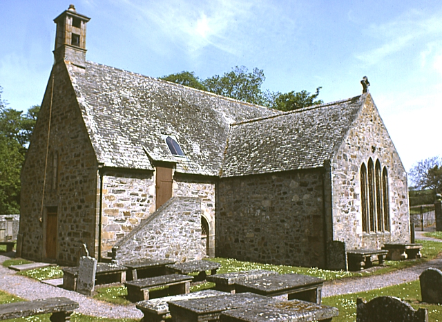
Cullen Church was known to have existed in 1236. The south aisle was added by Elena Hay in 1536 and dedicated to St Anne. It became a collegiate church in 1543 with 6 prebendaries and 2 singing boys to sing mass 'decently and in order every day'. Cullen Church was the centre of the old kirkton of Cullen until 1820-30 when township removed to present 'new town' of Cullen and the manse, which had been close by, rebuilt. ( see http://www.moraypresbytery.org.uk/churches/cullendeskford.html )
The church was founded as a chapel by King Robert Bruce. (see: https://archive.org/stream/imperialgazettee01wils#page/328/mode/2up )
The organs of en: Elizabeth de Burgh, the wife of en:Robert the Bruce are said to have been buried in its old kirk after her death in the area. Robert the Bruce made an annual payment to the village in gratitude for the treatment of his wife's body and its return south for burial.
A recent non-payment of this sum by the government was challenged and settled to the village's favour.
Writing in around 139-161, en:Ptolemy in his Geography mentions the River Celnius in the North East of Scotland. en:Both William Forbes Skene and en:George Chalmers identified the Celnius with Cullen Burn. (see: W. Cramond The Annals of Cullen, 1904)
The first mention of Cullen in Scottish history was in 962 when King Indulf was killed by the Norwegians (and/or Danes) at the mouth of the river Cullen (see: Anderson, Early Sources of Scottish History 1922 p 470 ) and referred to as the en:Battle of the Bauds. "Atween Coedlich and the sea, There lies Kings' sons three." Legend has it that within the vicinity, a Scots, a Danish and a Norwegian King are buried, marked by the three isolated rocks within Cullen Bay and named the "Three Kings". However, it is possible that these rocks derive their name from the similarity of the name Cullen with Culane (Cologne) as in the medieval mystery play "The Three Kings of Culane". (see: http://ads.ahds.ac.uk/catalogue/adsdata/PSAS_2002/pdf/vol_031/31_216_223.pdf W. CRAMOND; NOTES ON TUMULI IN CULLEN DISTRICT; AND NOTICE OF THE DISCOVERY OF TWO URNS AT FOULFORD, NEAR CULLEN (1897) Retrieved 29-12-2010 )
Beschreibung
| Beschreibung |
English: Cullen Auld Kirk. A recent listed building report by Historic Scotland is at http://hsewsf.sedsh.gov.uk/hslive/hsstart?P_HBNUM=2218 |
| Datum | |
| Quelle | From geograph.org.uk |
| Urheber | Anne Burgess |
| Namensnennung (von der Lizenz verlangt) | Anne Burgess / Cullen Auld Kirk / |
| Kameraposition | | Dieses und weitere Bilder auf OpenStreetMap |
|---|
_region:GB-GBN_heading:45.00&language=de)
| Objektposition | | Dieses und weitere Bilder auf OpenStreetMap |
|---|
_region:GB-GBN_heading:45.00&language=de)
Lizenz

|
Dieses Bild stammt aus der Sammlung des Projektes „Geograph British Isles“. Siehe die Seite der Fotografie für Kontaktinformationen. Das Urheberrecht dieses Bildes liegt bei Anne Burgess und ist lizenziert unter der Creative Commons Namensnennung-Weitergabe unter gleichen Bedingungen-2.0-Lizenz.
|
- Dieses Werk darf von dir
- verbreitet werden – vervielfältigt, verbreitet und öffentlich zugänglich gemacht werden
- neu zusammengestellt werden – abgewandelt und bearbeitet werden
- Zu den folgenden Bedingungen:
- Namensnennung – Du musst angemessene Urheber- und Rechteangaben machen, einen Link zur Lizenz beifügen und angeben, ob Änderungen vorgenommen wurden. Diese Angaben dürfen in jeder angemessenen Art und Weise gemacht werden, allerdings nicht so, dass der Eindruck entsteht, der Lizenzgeber unterstütze gerade dich oder deine Nutzung besonders.
- Weitergabe unter gleichen Bedingungen – Wenn du das Material wiedermischst, transformierst oder darauf aufbaust, musst du deine Beiträge unter der gleichen oder einer kompatiblen Lizenz wie das Original verbreiten.
Dateiversionen
Klicke auf einen Zeitpunkt, um diese Version zu laden.
| Version vom | Vorschaubild | Maße | Benutzer | Kommentar | |
|---|---|---|---|---|---|
| aktuell | 01:32, 1. Feb. 2010 | | 640 × 466 (268 KB) | GeographBot | == {{int:filedesc}} == {{Information |description={{en|1=Cullen Auld Kirk. A recent listed building report by Historic Scotland is at http://hsewsf.sedsh.gov.uk/hslive/hsstart?P_HBNUM=2218}} |date=1983-06-18 |source=From [http://www.geograph.org.uk/photo/ |
Dateiverwendung
Die folgenden 2 Seiten verwenden diese Datei:
Globale Dateiverwendung
Die nachfolgenden anderen Wikis verwenden diese Datei:
- Verwendung auf en.wikipedia.org
- Verwendung auf www.wikidata.org