Datei:Helsinki tram map.png
Zur Navigation springen
Zur Suche springen

Größe dieser Vorschau: 600 × 600 Pixel. Weitere Auflösungen: 240 × 240 Pixel | 480 × 480 Pixel | 768 × 768 Pixel | 1.200 × 1.200 Pixel
Originaldatei (1.200 × 1.200 Pixel, Dateigröße: 98 KB, MIME-Typ: image/png)
![]()
Diese Datei und die Informationen unter dem roten Trennstrich werden aus dem zentralen Medienarchiv Wikimedia Commons eingebunden.
![]()
Beschreibung
| Beschreibung |
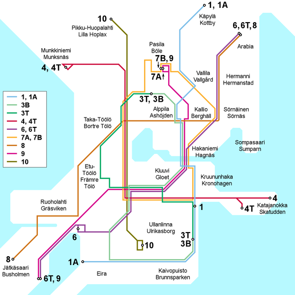
English: Map of the Helsinki tram network, current as of 30 March 2009. Place names in Finnish and Swedish. This file is being kept up to date (or at least attempted to) by Kjet.
Suomi: Kartta Helsingin raitiotieverkosta 30. maaliskuuta 2009 tilanteen mukaan. Paikannimet suomeksi ja ruotsiksi. Kjet pitää (tai ainakin yrittää pitää) tämän tiedoston ajantasalla.
Svenska: Kartan över Helsingfors spårvägslinjer, aktuell av 30 mars 2009. Namn på finska och svenska. Denna filet är uppdaterad av Kjet. |
| Datum | |
| Quelle | Eigenes Werk |
| Urheber | Kjet |

|
Dieses Bild des Typs Transport map sollte als Vektorgrafik im SVG-Format neu erstellt werden. Vektorformate haben zahlreiche Vorteile; weitere Information unter Commons:Media for cleanup. Wenn dir eine SVG-Version dieses Bildes vorliegt, so lade diese bitte hoch. Nach dem Hochladen der Datei ist diese Vorlage auf der aktuellen Bildbeschreibungsseite durch die Vorlage {{Vector version available}}, oder kürzer {{Vva}}, zu ersetzen. Es ist empfohlen die neue SVG-Datei „Helsinki tram map.svg“ zu nennen – dann benötigt die Vorlage vector version available (bzw. vva) keinen Parameter.
|
Lizenz
Ich, der Urheber dieses Werkes, veröffentliche es unter der folgenden Lizenz:
Diese Datei ist unter der Creative-Commons-Lizenz „Namensnennung 3.0 nicht portiert“ lizenziert.
- Dieses Werk darf von dir
- verbreitet werden – vervielfältigt, verbreitet und öffentlich zugänglich gemacht werden
- neu zusammengestellt werden – abgewandelt und bearbeitet werden
- Zu den folgenden Bedingungen:
- Namensnennung – Du musst angemessene Urheber- und Rechteangaben machen, einen Link zur Lizenz beifügen und angeben, ob Änderungen vorgenommen wurden. Diese Angaben dürfen in jeder angemessenen Art und Weise gemacht werden, allerdings nicht so, dass der Eindruck entsteht, der Lizenzgeber unterstütze gerade dich oder deine Nutzung besonders.
Dateiversionen
Klicke auf einen Zeitpunkt, um diese Version zu laden.
| Version vom | Vorschaubild | Maße | Benutzer | Kommentar | |
|---|---|---|---|---|---|
| aktuell | 16:40, 3. Feb. 2013 | | 1.200 × 1.200 (98 KB) | Kjet | Updated with the autumn 2012 extension of line 9 and the new line 6T opened in January 2013. |
| 23:00, 11. Jul. 2012 |  | 1.200 × 1.200 (96 KB) | Kjet | Updated with the changed route of line 8 from 2012-01-01. Apologies for the delay. | |
| 11:22, 13. Jan. 2010 |  | 1.200 × 1.200 (96 KB) | Kjet | Corrected the accidentally reversed directions for lines 7A and 7B. | |
| 21:51, 29. Mär. 2009 |  | 1.200 × 1.200 (96 KB) | Kjet | {{Information |Description={{en|1=Map of the Helsinki tram network, current as of 30 March 2009. Place names in Finnish and Swedish. This file is being kept up to date (or at least attempted to) by Kjet.}} {{fi|1=Kartta Helsingin raitiotieve |
Dateiverwendung
Keine Seiten verwenden diese Datei.
Globale Dateiverwendung
Die nachfolgenden anderen Wikis verwenden diese Datei:
- Verwendung auf en.wikipedia.org
- Verwendung auf es.wikivoyage.org
- Verwendung auf he.wikivoyage.org
- Verwendung auf it.wikipedia.org
- Verwendung auf ja.wikipedia.org
- Verwendung auf tr.wikipedia.org