Datei:Medieval map of Cairo.png
Zur Navigation springen
Zur Suche springen
Größe dieser Vorschau: 379 × 599 Pixel. Weitere Auflösungen: 152 × 240 Pixel | 303 × 480 Pixel | 486 × 768 Pixel | 648 × 1.024 Pixel | 1.336 × 2.112 Pixel
Originaldatei (1.336 × 2.112 Pixel, Dateigröße: 298 KB, MIME-Typ: image/png)
![]()
Diese Datei und die Informationen unter dem roten Trennstrich werden aus dem zentralen Medienarchiv Wikimedia Commons eingebunden.
![]()
Beschreibung
| Beschreibung |
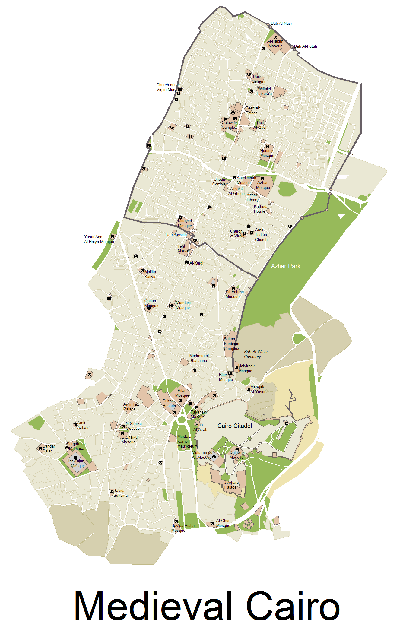
English: A Map showing the size of Medieval Cairo, with remaining Monuments today, map Includes Cairo from its establishing, till the late 17th century - NOTE: Bab Al-Futuh and Bab Al-Nasr are wrongly switched. See revised version here: https://commons.wikimedia.org/wiki/File:Medieval_map_of_Cairo_revised.png |
| Datum | |
| Quelle |
i used several Print screens from a google map, and then worked on it via Microsoft paint, and then searched for boundries of the city, and location of monuments online. |
| Urheber | Arab Hafez |
Lizenz
Ich, der Urheberrechtsinhaber dieses Werkes, veröffentliche es hiermit unter der folgenden Lizenz:

|
Es ist erlaubt, die Datei unter den Bedingungen der GNU-Lizenz für freie Dokumentation, Version 1.2 oder einer späteren Version, veröffentlicht von der Free Software Foundation, zu kopieren, zu verbreiten und/oder zu modifizieren; es gibt keine unveränderlichen Abschnitte, keinen vorderen und keinen hinteren Umschlagtext.
Der vollständige Text der Lizenz ist im Kapitel GNU-Lizenz für freie Dokumentation verfügbar. |
Diese Datei ist unter der Creative-Commons-Lizenz „Namensnennung – Weitergabe unter gleichen Bedingungen 3.0 nicht portiert“ lizenziert.
- Dieses Werk darf von dir
- verbreitet werden – vervielfältigt, verbreitet und öffentlich zugänglich gemacht werden
- neu zusammengestellt werden – abgewandelt und bearbeitet werden
- Zu den folgenden Bedingungen:
- Namensnennung – Du musst angemessene Urheber- und Rechteangaben machen, einen Link zur Lizenz beifügen und angeben, ob Änderungen vorgenommen wurden. Diese Angaben dürfen in jeder angemessenen Art und Weise gemacht werden, allerdings nicht so, dass der Eindruck entsteht, der Lizenzgeber unterstütze gerade dich oder deine Nutzung besonders.
- Weitergabe unter gleichen Bedingungen – Wenn du das Material wiedermischst, transformierst oder darauf aufbaust, musst du deine Beiträge unter der gleichen oder einer kompatiblen Lizenz wie das Original verbreiten.
Du darfst es unter einer der obigen Lizenzen deiner Wahl verwenden.
Dateiversionen
Klicke auf einen Zeitpunkt, um diese Version zu laden.
| Version vom | Vorschaubild | Maße | Benutzer | Kommentar | |
|---|---|---|---|---|---|
| aktuell | 02:01, 12. Jan. 2018 | | 1.336 × 2.112 (298 KB) | SteinsplitterBot | Bot: Image rotated by 270° |
| 00:01, 12. Nov. 2017 |  | 2.112 × 1.336 (321 KB) | SteinsplitterBot | Bot: Image rotated by 90° | |
| 16:42, 4. Jan. 2013 |  | 1.336 × 2.112 (372 KB) | Arab Hafez | {{subst:Upload marker added by en.wp UW}} {{Information |Description = {{en|a Map showing the size of Medieval Cairo, with remaining Monuments today, map Includes Cairo from its establishing, till the late 17th century}} |Source = i used several Print ... |
Dateiverwendung
Die folgende Seite verwendet diese Datei:
Globale Dateiverwendung
Die nachfolgenden anderen Wikis verwenden diese Datei:
- Verwendung auf el.wikipedia.org
- Verwendung auf en.wikipedia.org
- Verwendung auf it.wikipedia.org
- Verwendung auf mai.wikipedia.org
- Verwendung auf vi.wikipedia.org
- Verwendung auf www.wikidata.org