Datei:SE postcode area map.svg
Zur Navigation springen
Zur Suche springen

Größe der PNG-Vorschau dieser SVG-Datei: 750 × 600 Pixel. Weitere aus SVG automatisch erzeugte PNG-Grafiken in verschiedenen Auflösungen: 300 × 240 Pixel | 600 × 480 Pixel | 960 × 768 Pixel | 1.280 × 1.024 Pixel | 2.560 × 2.048 Pixel | 1.000 × 800 Pixel
Originaldatei (SVG-Datei, Basisgröße: 1.000 × 800 Pixel, Dateigröße: 632 KB)
![]()
Diese Datei und die Informationen unter dem roten Trennstrich werden aus dem zentralen Medienarchiv Wikimedia Commons eingebunden.
![]()
W3C-validity not checked.
Beschreibung
| Beschreibung |
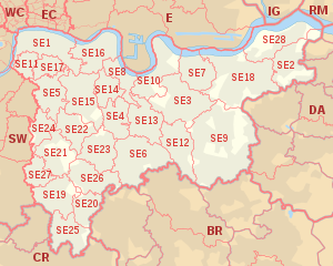
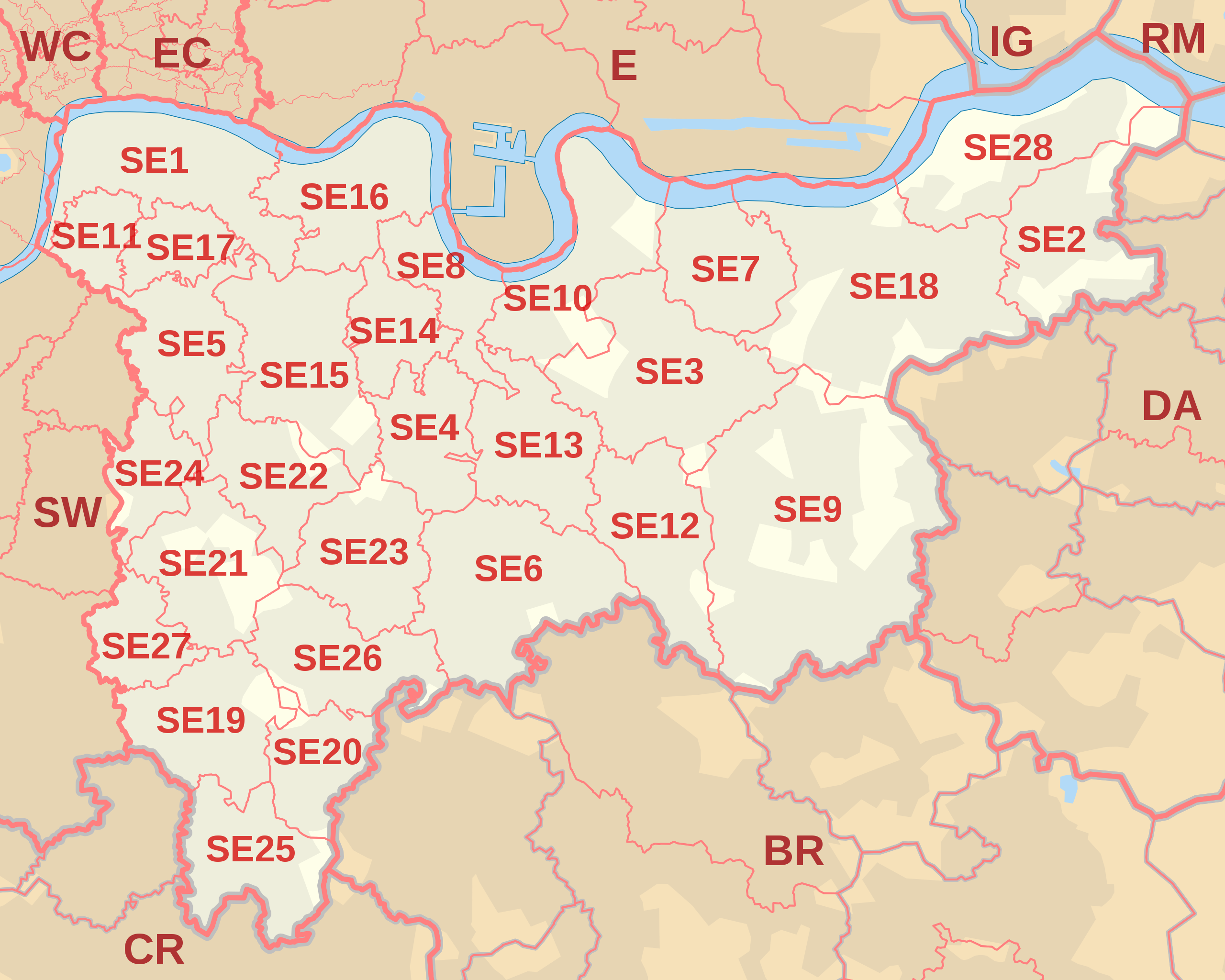
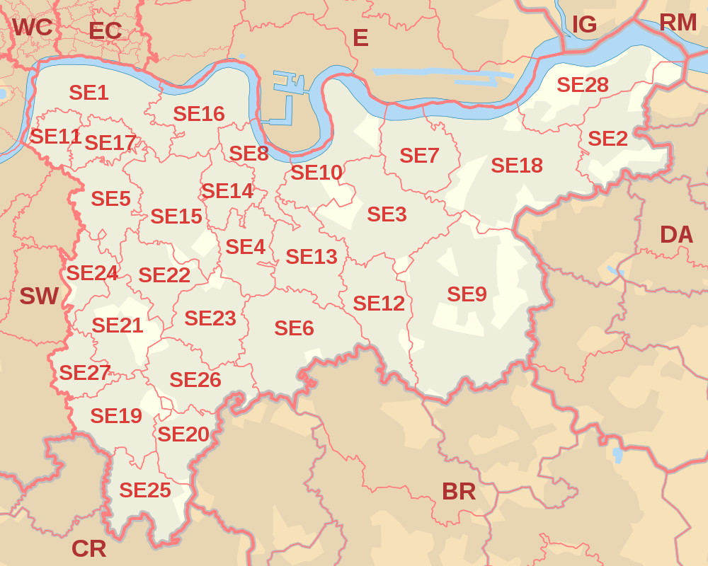
English: Labelled map of Royal Mail postcode districts of the SE postcode area.
Indicative postcode districts shown in red, post towns shown in grey. Equirectangular projection with latitude stretching 160%, WGS84 datum. Geographic limits:
|
| Datum | |
| Quelle |
Derived from Ordnance Survey OS OpenData.
|
| Urheber | Richardguk |
| Kameraposition | | Dieses und weitere Bilder auf OpenStreetMap |
|---|
Siehe auch  
|
Lizenz
Ich, der Urheber dieses Werkes, veröffentliche es unter der folgenden Lizenz:
Diese Datei ist unter der Creative-Commons-Lizenz „Namensnennung – Weitergabe unter gleichen Bedingungen 3.0 nicht portiert“ lizenziert.
- Dieses Werk darf von dir
- verbreitet werden – vervielfältigt, verbreitet und öffentlich zugänglich gemacht werden
- neu zusammengestellt werden – abgewandelt und bearbeitet werden
- Zu den folgenden Bedingungen:
- Namensnennung – Du musst angemessene Urheber- und Rechteangaben machen, einen Link zur Lizenz beifügen und angeben, ob Änderungen vorgenommen wurden. Diese Angaben dürfen in jeder angemessenen Art und Weise gemacht werden, allerdings nicht so, dass der Eindruck entsteht, der Lizenzgeber unterstütze gerade dich oder deine Nutzung besonders.
- Weitergabe unter gleichen Bedingungen – Wenn du das Material wiedermischst, transformierst oder darauf aufbaust, musst du deine Beiträge unter der gleichen oder einer kompatiblen Lizenz wie das Original verbreiten.
Diese Datei ist von der Ordnance Survey des Vereinigten Königreichs unter deren OS OpenData License
lizenziert. Kurz gesagt: Du kannst die Datei verbreiten und ändern, solange man sie der Ordnance Survey and Royal Mail zuordnet (einschließlich Jahr). Namensnennung: Contains Ordnance Survey and Royal Mail data © Crown copyright and database right (year) Hinweis: Abgeleitete Werke können unter jeder Creative Commons Attribution 3.0-Lizenz lizenziert werden. |
_(St_Edwards_Crown).svg)
|
This file is licensed under the United Kingdom Open Government Licence v3.0. |
See also: Meta for information on usage on Wikimedia wikis.
|
Dateiversionen
Klicke auf einen Zeitpunkt, um diese Version zu laden.
| Version vom | Vorschaubild | Maße | Benutzer | Kommentar | |
|---|---|---|---|---|---|
| aktuell | 14:07, 16. Okt. 2012 | | 1.000 × 800 (632 KB) | Richardguk | revised styling for SE postcode area map |
| 20:24, 10. Okt. 2012 |  | 1.000 × 800 (611 KB) | Richardguk | User created page with UploadWizard |
Dateiverwendung
Die folgende Seite verwendet diese Datei:
Globale Dateiverwendung
Die nachfolgenden anderen Wikis verwenden diese Datei:
- Verwendung auf en.wikipedia.org
- Verwendung auf fr.wikipedia.org
- Verwendung auf it.wikipedia.org