Datei:Tribal Kingdom of Samo-sl version.PNG
Zur Navigation springen
Zur Suche springen

Größe dieser Vorschau: 601 × 600 Pixel. Weitere Auflösungen: 241 × 240 Pixel | 481 × 480 Pixel | 852 × 850 Pixel
Originaldatei (852 × 850 Pixel, Dateigröße: 149 KB, MIME-Typ: image/png)
![]()
Diese Datei und die Informationen unter dem roten Trennstrich werden aus dem zentralen Medienarchiv Wikimedia Commons eingebunden.
![]()
| Beschreibung |
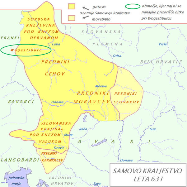
English: Tribal Kingdom of Samo. Map is based on the maps in: Korošec, Paola (1990): Alpski Slovani- Die Alpenslawen, Ljubljana, Znanstveni institut Filozofske fakultete, unnamed map on the page 18; Šavli, Jožko (1995): Sovenija: Podoba evropskega naroda, Bilje, založba Humar, map Samovo kraljestvo on the page 19; Barford, Paul M. (2001): The Early Slavs, Cornell University Press, map on the page 356, named Geography of the Slav settlement of Polabia- concerning the location of Sorbs east of Saale; map IV on page 397 for Sorbian culture, Devinska-Nova ves culture and Avarian state. It is also based on descriptions in: Štih, Peter (2001): Ozemlje Slovenije v zgodnjem srednjem veku: osnovne poteze zgodovinskega razvoja od začetka 6. do konca 9. stoletja, Ljubljana, Filozofska fakulteta; page 30- concerning the relationsship between king Samo and the ancestros of Slovenians; Korošec, Paola (1990): Alpski Slovani- Die Alpenslawen, Ljubljana, Znanstveni institut Filozofske fakultete, page 17 – concerning the Sorbs and their duke Dervan. For eastern and southern extant of tribal kingdom: known territories are shown by the scheme of franco-slavic border and information about the conflicts with Avars is imlemented. The inclusion of Bohemian basin is followed. Contacts with Avars are reached through the territory of Moravians anf Eastern Alps. The territories further east and south, which are in proximity of Avars, could be parts of tribal kingdom, too. |
| Datum | (UTC) |
| Quelle | |
| Urheber |
|
| Dieses Bild wurde digital nachbearbeitet. Folgende Änderungen wurden vorgenommen: The map of Danube basin was used to create map of Kingdom of Samo. Das Originalbild kann hier eingesehen werden: Waterways of SE Central Europe.svg:
|
Ich, der Urheber dieses Werkes, veröffentliche es unter der folgenden Lizenz:
| Ich, der Urheberrechtsinhaber dieses Werkes, veröffentliche es als gemeinfrei. Dies gilt weltweit. In manchen Staaten könnte dies rechtlich nicht möglich sein. Sofern dies der Fall ist: Ich gewähre jedem das bedingungslose Recht, dieses Werk für jedweden Zweck zu nutzen, es sei denn, Bedingungen sind gesetzlich erforderlich. |
Ursprüngliches Datei-Logbuch
This image is a derivative work of the following images:
- File:Waterways_of_SE_Central_Europe.svg licensed with PD-self
- 2010-01-08T20:49:27Z Kmiki87 1415x1059 (292577 Bytes) {{Information |Description={{en|1=Waterways along the central and lower Danube, including the Bohemian and Carpathian Basins, the northern Balkans, parts of Austria, southern Poland and Western Ukraine.}} |Source={{own}} |Aut
Hochgeladen mit derivativeFX
Dateiversionen
Klicke auf einen Zeitpunkt, um diese Version zu laden.
| Version vom | Vorschaubild | Maße | Benutzer | Kommentar | |
|---|---|---|---|---|---|
| aktuell | 20:21, 9. Jan. 2011 | | 852 × 850 (149 KB) | Bostjan46 | The text for Dalmatian Slavs was changed (Slavic tribes under avarian rule>>Ancestors of Croats). |
| 19:13, 9. Jan. 2011 |  | 852 × 850 (150 KB) | Bostjan46 | {{Information |Description={{en|1=Tribal Kingdom of Samo. Map is based on the maps in: Korošec, Paola (1990): ''Alpski Slovani- Die Alpenslawen'', Ljubljana, Znanstveni institut Filozofske fakultete, unnamed map on the page 18; Šavli, Jožko (1995): '' |
Dateiverwendung
Die folgenden 3 Seiten verwenden diese Datei:
Globale Dateiverwendung
Die nachfolgenden anderen Wikis verwenden diese Datei:
- Verwendung auf az.wikipedia.org
- Verwendung auf be.wikipedia.org
- Verwendung auf bg.wikipedia.org
- Verwendung auf gl.wikipedia.org
- Verwendung auf lt.wikipedia.org
- Verwendung auf pl.wikipedia.org
- Verwendung auf ru.wikipedia.org
- Verwendung auf sl.wikipedia.org
- Verwendung auf sr.wikipedia.org
- Verwendung auf sv.wikipedia.org
- Verwendung auf szl.wikipedia.org