Datei:USA 09855 Grand Canyon Luca Galuzzi 2007.jpg
Originaldatei (2.000 × 1.333 Pixel, Dateigröße: 2,99 MB, MIME-Typ: image/jpeg)
![]()
Diese Datei und die Informationen unter dem roten Trennstrich werden aus dem zentralen Medienarchiv Wikimedia Commons eingebunden.
![]()
| Beschreibung |
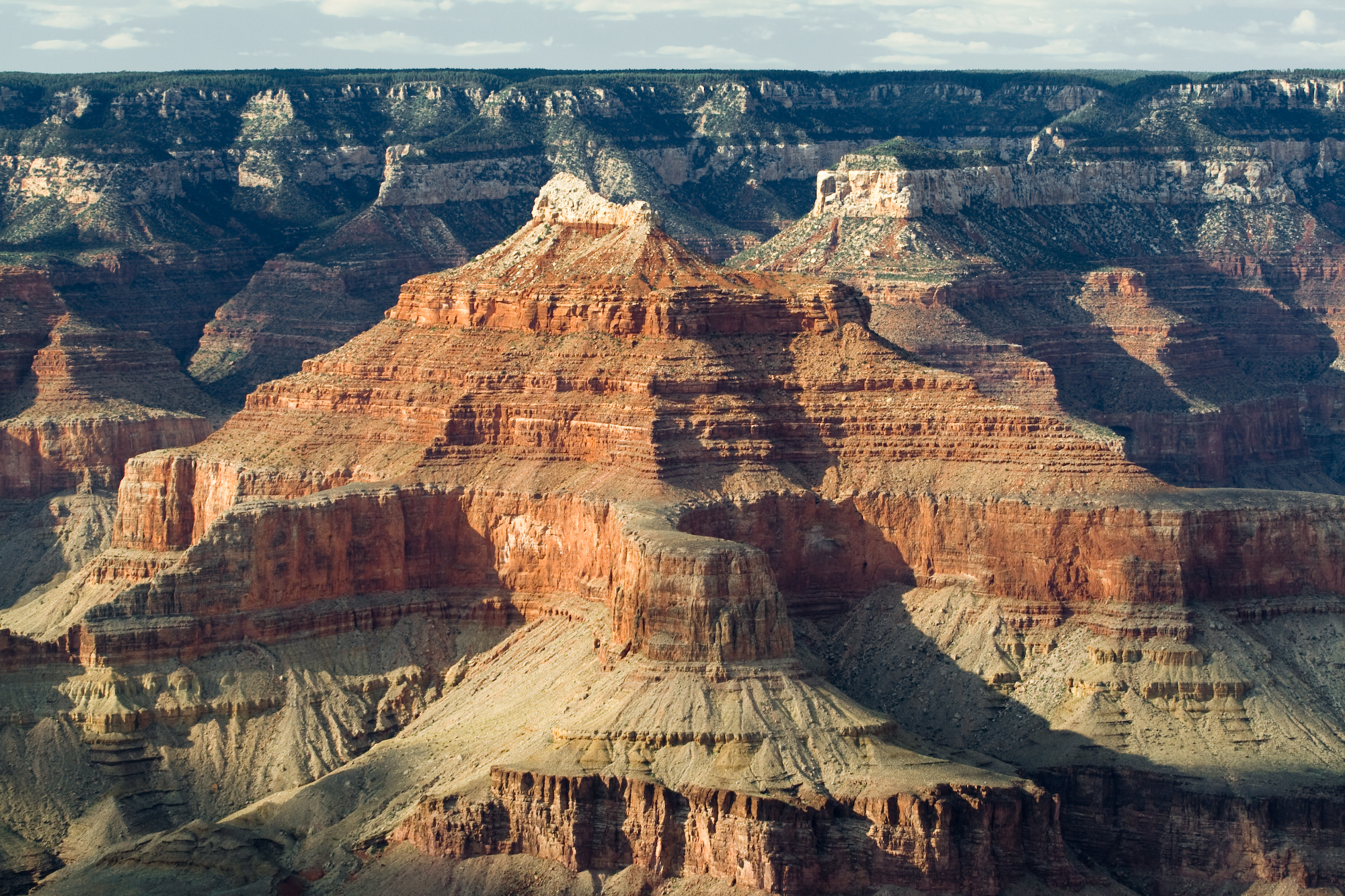
English: (original description)--Grand Canyon, Arizona. Nearly two billion years of the Earth's history have been exposed as the Colorado River and its tributaries cut their channels through layer after layer of rock while the Colorado Plateau was uplifted. Arizona, USA. (view approx. due-north)--From Dana Butte region, on en:Tonto Trail-(on the Tonto Platform), southside of Granite Gorge, Colorado River. The en:Isis Temple prominence, 7,012 feet (2,137 m), is on an uplifted, faulted-block, with Sumner Butte (unseen) to right, and a 3rd "prominence", also part of the block, at the southwest of Bright Angel Canyon-(creek)-(Bright Angel Fault). The northeast flank of the block is down Phantom Creek-(canyon, to Bright Angel Canyon)-(the Grandview Fault). The geology units beyond, are consequently offset, (lower by 200-250? ft). The landmark point, to the right of ISIS peak, is the end of The Colonnade, 7,296 feet (2,224 m), on the next canyon southeast from Tiyo Point, 7,762 feet (2,366 m), of the southwest Kaibab Plateau, (seen in the background); (the viewpoint looks slightly uphill from Dana Point). Tiyo Point is 3-mi from Isis Temple (peak), and The Colonnade, (though appears as a twin peak), is 1.5 mi from Isis. Isis Temple is topped by the lowest (buff-white unit), en:Coconino Sandstone, then a short slope of Hermit Shale, and the Supai Group "redbeds". The cliffs below the 'redbeds' are Redwall Limestone; then upon the slopes of en:Muav Limestone & Bright Angel Shale (No Tapeats Sandstone). Instead the base of Isis Temple sits on a 'mountain island' of Shinumo Quartzite of the en:Ukar Group, part of the Grand Canyon basement rock geology. (Tapeats Sandstone is in all the landforms surrounding the uplifted block.) |
||
| Datum | |||
| Quelle | Photo taken by (Luca Galuzzi) * http://www.galuzzi.it | ||
| Urheber | Luca Galuzzi (Lucag) | ||
| Genehmigung (Weiternutzung dieser Datei) |
I, Luca Galuzzi, der Nutzungsrechtsinhaber dieses Werkes, veröffentlicht es hiermit unter der folgenden Lizenz: Diese Datei ist unter der Creative-Commons-Lizenz „Namensnennung – Weitergabe unter gleichen Bedingungen 2.5 generisch“ (US-amerikanisch) lizenziert. Namensnennung: I, Luca Galuzzi
|

| Bildnotizen | Diese Datei ist annotiert: Betrachte diese auf Commons. |
Dateiversionen
Klicke auf einen Zeitpunkt, um diese Version zu laden.
| Version vom | Vorschaubild | Maße | Benutzer | Kommentar | |
|---|---|---|---|---|---|
| aktuell | 23:26, 5. Sep. 2007 | | 2.000 × 1.333 (2,99 MB) | Lucag | {{Information |Description=Grand Canyon, Arizona. Nearly two billion years of the Earth's history have been exposed as the Colorado River and its tributaries cut their channels through layer after layer of rock while the Colorado Plateau was uplifted. Ari |
Dateiverwendung
Die folgende Seite verwendet diese Datei:
Globale Dateiverwendung
Die nachfolgenden anderen Wikis verwenden diese Datei:
- Verwendung auf en.wikipedia.org
- Verwendung auf en.wikiversity.org
- Verwendung auf he.wikipedia.org
- Verwendung auf hu.wikipedia.org
- Verwendung auf pl.wikipedia.org
- Verwendung auf pl.wiktionary.org