Diskussion:Universitas Valachorum
Nach der Universitas Valachorum starb auch das Königreich Ungarn[Quelltext bearbeiten]
Paradoxerweise bezieht sich die Anspielung auf den Vampir und das Opfer eines verbotenen Buches.
Das Ende der Selbstverwaltung kam mit Schlacht bei Mohács (1526).
Alle kausalen Zusammenhänge sollten im Artikel reflektiert und kommentiert werden.--Bodinski2 (Diskussion) 14:01, 10. Jul. 2021 (CEST)
Zur Karte[Quelltext bearbeiten]

Hallo,
die die letzte Löschung einer älteren Karte und Ersetzung durch eine "akademische Karte" ist in diesem Artikel leider unpassend und auch falsch beschrieben. Das muss ich hier begründen, die Zusammenfassungszeile ist zu kurz:
1. Die Karte war falsch erklärt. Sie zeigt keine "Walachen Siedlungen" (sic!), sondern "first mention of Romanian kenazate's seat (during the rule of)..." (violett, rot und gelb), also "erste Erwähnung eines Sitzes eines rumänischen Knes#Rumänen (während der Herrschaft von)...", ein Titel, der entweder ein stammesadliges Clanoberhaupt oder einen adligen Fürsten bezeichnen kann. Das besagt aber wenig über die tatsächlich vorhandene rumänische Besiedlung und die Anzahl der bekannten Siedlungen aus den gewählten Zeiträumen 1301-1400. Allein die insgesamt 9 hellblauen Punlte zeigen rumänische Dörfer, die davor, in den 1290er Jahren nachgewiesen sind. Wenn man sich eine weitere Karte desselben Autors (András Bereznay) ansieht (walachische Dörfer aus dem 14. Jahrhundert hier: rote Punkte), ist offensichtlich, dass wesentlich mehr Walachendörfer aus der Zeit bekannt sind! Deshalb ist die Beschriftung falsch.
2. Wenn man sich die übrigen Karten von András Bereznay online und auch hier bei WP:Commons genau betrachtet, ist er eindeutig ein sehr entschiedener der "Walachischen Migrationshypothese", nach der Walachen/Rumänen überhaupt erst seit 13. Jh. Rumänien und Siebenbürgen besiedelten und die Magyaren zuvor dort gesiedelt hätten. Siehe dazu unser Artikel Dako-romanische Kontinuitätstheorie, wo sie als Gegenthese erörtert wird. Überflüssig zu erwähnen, dass das auch ein seit dem 19. Jh. nationalistisch aufgeladenes rumänisch-ungarisches Streitthema ist, auch jetzt wieder und in der WP, besonders bei commons schon länger ausgetragen. András Bereznay hat nach seiner Vita ziemlich sicher auch eine ungarisch-konservative Anbindung. Rein wissenschaftlich ist das ein sehr schwer, eher indizienhaft zu erforschendes Thema, ab wann Magyaren und Rumänen in Siebenbürgen gelebt haben. Heute geht es aber nicht mehr, wie im 19. Jh. um die Extremstandpunkte "Rumänen sind seit der Antike in Siebenbürgen" vs. "Rumänen kamen erst im 13. Jh. nach den Magyaren nach Siebenbürgen", sondern ist differenzierter. Eine Migration von Süden im 12./13. Jh. leugnen heute die wenigsten, die Frage ist eher, ob schon zuvor romanischsprachige Bewohner in Siebenbürgen und an den Karpaten in Resten lebten. Das kann hier nicht im einzelnen vorgestellt werden, kurzer Überblick: dieser wissenschaftliche Artikel eher im Sinne der "Dako-romanischen Kontinuitätstheorie" von 1987, der eine rumänische Anwesenheit ab etwa 1050 in Siebenbürgen als nahezu sicher sieht (und sie davor in einigen "Kerngebieten" sehr wahrscheinlich findet) <---> dieser geschichtswissenschaftliche ungarische Überblick im Sinne der "walachischen Migrationstheorie" von 1989, der rumänische Anwesenheit in Siebenbürgen ab 1166 für sicher hält (damit 130 Jahre vor András Bereznay, dessen Karten doch einen extremen Standpunkt einnehmen).

3. Für diesen Artikel hat diese Streitfage aber überhaupt keine Relevanz. Hier geht es allein um die Universitas Valachorum (Adelsaufgebot der "Gesamtheit der Walachen"), deren Anwesenheit als ständisches Aufgebot, neben den Abordnungen der Universitas Hungarorum (Aufgebot ungarischer Adliger), denen der Universitas Siculorum (Gesamtheit der Szekler) und der Universitas Saxonorum (Gesamtheit der Siebenbürger Sachsen) auf dem Siebenbürgischen Landtag von Weißenburg 1291 und von Turda 1355 definitiv bewiesen und allgemein bekannt ist. Ebenso wird er urkundlich in einigen anderen Quellen beschrieben, darunter 1288. Wie gefestigt sie als politische Einheit war, ist Gegenstand von Debatten, aber es gab sie. Es waren auch, wie in Ungarn üblich, eher "personal" (also nach individueller Herkunft), nicht "territorial" definierte rechtliche Autonomien. Auch kennt man für diese Zeiten die walachisch besiedelten Gebiete. Nur darum geht es in diesem Artikel, nicht um leidige Fragen, ob Ungarn oder Rumänen zuerst da waren oder um die schon historisch interessantere Frage, ab wann sie sich nachweisen lassen.
4.Wirklich unschön ist, dass derselbe User nebenstehende vorher verlinkte Karte trotz Konsens auf der Diskussionsseite bei Commons eigenmächtig revertiert hat, siehe Bearbeitungshistorie bei Commons. Die Karte zeigt so auch nicht mehr, was der Titel (auf Ungarisch) verspricht.
5. Deshalb werde ich eine wissenschaftlich wesentlich besser begründete Karte einfügen. Mit einigen Details da bin ich bei den Zeitpunkten aus gutem Grund nicht ganz glücklich, werde es aber in der Beschreibung erwähnen. Allerdings sehe ich gerade zu spät, dass die entfente Karte auch sehr gut belegt war, war wohl purer Vandalismus... Mal sehen, welche besser ist. Übersichtlicher ist die rechts.--WajWohu (Diskussion) 23:33, 17. Feb. 2024 (CET)
- Hi @WajWohu,
- (I understand German, but I am more confident in English)
- Thanks for your research! I would like to talk about this image:
- https://commons.wikimedia.org/wiki/File:Kis-vlachföldek.png
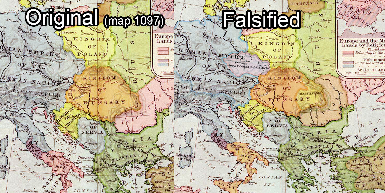
- This map is a photoshopped fantasy map by a blocked user Special:Contributions/Julieta39, I show an another fake map example, created by the same user, (finally I found and I replaced the original French map), Juliteta detached Transylvania from Hungary and photoshopped a big Romania country there: File:Europe Moyen-âge.jpg in 1300. Romanian historiography with the Daco-Roman myth produced a lot of absurd fake maps to justify the territorial claims againts Hungary. Dacia!? in the 9-13th century [11] fake map from 1980s from the national-communist times, Romania 9-13th century: [10]. If we see international Europe maps, we will not find this "Romania" country in the historical maps of Europe of that timeline: [11][12][13] Those maps are clearly a falsifications and abuse of the international and Hungarian historiography.
- Many users from Romania do the same things, removing Transylvania from medieval Hungary and making Romanian country from that period against international academic maps, other example: Commons:Deletion requests/File:Europe 1097-corrected.jpg
- I see Enlightenment1685 summarized well the things on that image talk page.
- The English article with many academic soruces: https://en.wikipedia.org/wiki/Vlach_law Nobody deny the existence of Vlach law. The Vlach law was a formation of taxation and special rights, not autonomy regions with borders. What is the academic source of that Vlach regions in 1200s Hungary which was arbitrary drawn by an user?
- This was the base map: File:Hungary 13th cent.png
- This is the academic source map: https://djnaploja.files.wordpress.com/2015/11/magyar-kirc3a1lysc3a1g-xiii-sz.jpg
- We cannot see borders for that "Vlach law" area in the academic base map, according to the Hungarian historiography Vlach law was introduced in Hungary in the 14th century and not in the 13th century, in Hungarian sources the number of Vlachs was small in the 13th century, and I have academic sources regarding the 14th century which shows the increase of Vlach settlements in Hungary.
- The purpose of that photoshopped map is serving the Daco-Roman myth: "always majority Romanians between Tisza-Dneister river in that huge 300,000km2 land and we hid in caves for 1000 years and then suddenly emerged in Transylvania" just the problem, nobody knew about that allegedly always majority people before 1200...
- British historian, Martyn Rady - Nobility, land and service in medieval Hungary: page 90 [2] "The sources consistently refer to Wallachia as being a largely uninhabited woodland before the thirteenth century, and, until this time, they contain no explicit references to Vlachs either here or anywhere in Hungary and Transylvania."
- At the conference held in Freiburg in 2001, eight German, two Hungarian and one Romanian historians and linguists debated the issue of Daco-Romanian continuity and took a 10:1 position against it. [3]
- I suggest to remove fake maps from Wikipedia. I do not see any academic maps which support that arbitrary drawn areas with Vlach law.
- --OrionNimrod (Diskussion) 15:44, 18. Feb. 2024 (CET)
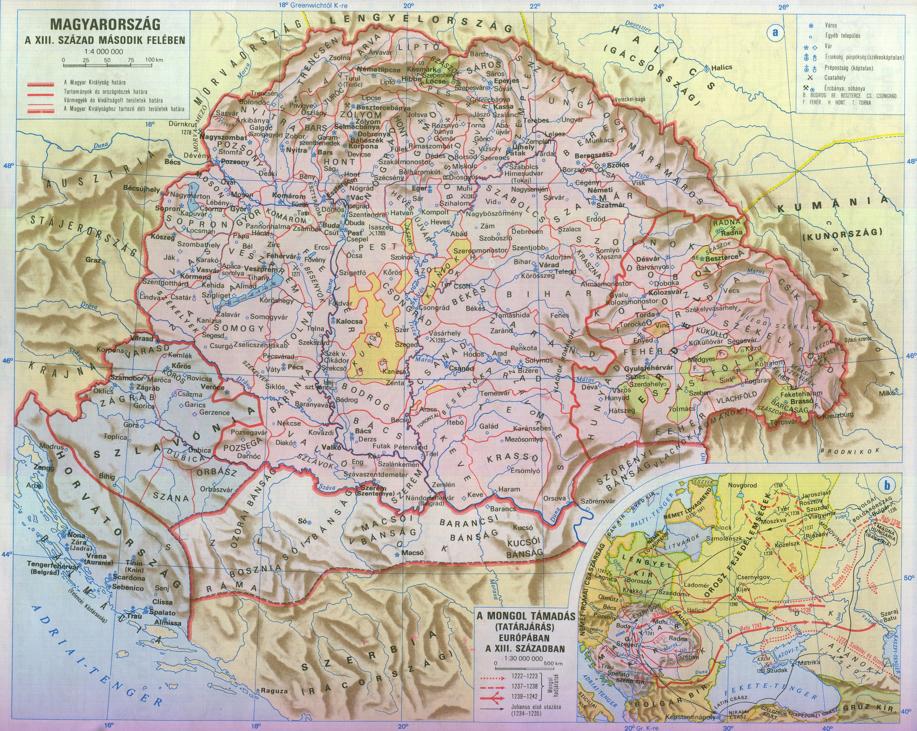
- https://commons.wikimedia.org/wiki/File:Magyarország_XII-XIII_század_második_felében.jpg The bottom map is a correct academic map, but we can clearly see the manually drawn above colored map, what does mean that colors? That was original a geography not a political map, I think this was the base: https://static-cdn.arcanum.com/nfo-resources/pannon_pic/pannon/panfo-11_4.jpg. I found the fantasy map in a Romanian website, which state the red areas are "Romanians states in 1100s = 12th century": https://www.rumaniamilitary.ro/valahiile-din-secolul-xii "As can be seen in the map below, the contemporary Hungarian map of the area of Hungary and the neighboring regions, as they were recorded in Hungarian documents from the 12th century, there were several Romanian state formations, marked in red" I think we should use real academic maps, or maps which are based on academic maps and not fantasy/unsourced fake history maps --OrionNimrod (Diskussion) 15:47, 18. Feb. 2024 (CET)
- Hello @OrionNimrod: nice to discuss with you, it is a very complex discussion on different levels, be patient please, I cannot answer all points in one evening.
- First I never thought about the possibility of manual falsification of old maps, but about the possibility they may transport outdated facts and connections. But you showed me, it is. The first map you showed me File:Europe Moyen-âge.jpg I checked the original, historical map of M.M.Drioux & Ch.Leroy, it is here. Of coure I knew, there was no united Romania or independent Romanian lands around 1300, but that map showed never old mistakes, it is really a strong, harsh falsification made by Julieta39.
- So I am also convinced, the first, upper map in the article know is also a falsification based on that map. I introduced it yesterday, but I knew the Vlach-areas in today's Slovakia around 1200 and the Jászok and Kunok in central Hungary are nonsense before 1200. They arrived later (Mongol invasion around 1241 and Vlachs in Slovakia 14th/15th to 18th century). I'm know convinced, it is not an old, outdated mistake, it is also a falsification.
- But know more sensitive on falsifications you showed me that map as original source map of the second lower map we have in the article now. But I can clearly see, this map is also manipulated, not original. The Szekely lands have a minimal darker purple color than the rest of Hungarian lands but the small extra-territorial, isolated Aranyos-szék westwards in northern central Transsylvania kept in orange accidentally again. So it seems to me, there's also a manipulation in this map.
- https://commons.wikimedia.org/wiki/File:Magyarország_XII-XIII_század_második_felében.jpg The bottom map is a correct academic map, but we can clearly see the manually drawn above colored map, what does mean that colors? That was original a geography not a political map, I think this was the base: https://static-cdn.arcanum.com/nfo-resources/pannon_pic/pannon/panfo-11_4.jpg. I found the fantasy map in a Romanian website, which state the red areas are "Romanians states in 1100s = 12th century": https://www.rumaniamilitary.ro/valahiile-din-secolul-xii "As can be seen in the map below, the contemporary Hungarian map of the area of Hungary and the neighboring regions, as they were recorded in Hungarian documents from the 12th century, there were several Romanian state formations, marked in red" I think we should use real academic maps, or maps which are based on academic maps and not fantasy/unsourced fake history maps --OrionNimrod (Diskussion) 15:47, 18. Feb. 2024 (CET)
![[11]](https://stefanteris.files.wordpress.com/2013/02/atlas-istoric-geografic-al-neamului-romc3a2nesc_07.jpg)
![[10]](https://tortenelemportal.hu/wp-content/uploads/2012/05/roman-9-13-sz.jpg)
![[11]](https://commons.wikimedia.org/wiki/File:Europe_mediterranean_1190.jpg)
![[12]](https://upload.wikimedia.org/wikipedia/commons/d/d2/People%27s_Crusade_%28cs%29.JPG)
![[13]](https://commons.wikimedia.org/wiki/File:Europe_in_the_14th_Century.jpg)
- I don't want to discuss the question of Romanian origins here, because this is off-topic for our article. But the map from András Bereznay upstairs in that discussion is even more an argument about this discussion (like that map of András Bereznay), than a good illustration of "Universitas Valachorum" inside Transsylvania. (For me it is a historical interesting question, but without political or national implications. If somebody would tell me, there would be no sights of a northern Vlach migration I wouldn't believe it. But were the elusive inhabitants of sparsely populated pre-Magyar and pre-Vlach Transsylvania 7th-10th century only "Slavs" or were other groups amongst them? It is difficult to decide only on archeological base, but I accept linguistic indications like Albanian substratum inside Romanian language. But this is not the question here!)
- But I am not convinced about the erasure of "en:Vlach law" in the former map in article (second map in this discussion site). The system of internal use of Vlach law + only royal (not noble) taxes + obligation of succeed to royal Hungarian army for the Vlach sheperds was a "personal" privilege/right for all of the members of Vlach communities which settled in the mountainious areas in Maramures, in Apuseni-Mountains (Erdély-Bihar-Szatmár-Hegység) in Western Transylvania and more western areas (Bihár), in the mountainious slopes in South-Carpathian ranges and in the Region today called "Banate" near Temesvár (Hatzeg-Region and west of it and of Söreny Bánság/Banate Severin). But the areas the map is showing as "Vlach law" are the areas they settled, mostly as sheperds according to that map of András Bereznay (red dots there). Those were "personal" rights to use their own (Vlach) law and to pay only royal taxes and royal military succeed, not "territorial" right for all the inhabitants of that area, only for the Vlach sheperds. But in times of "Universitas Valachorum" in Transsylvania they had their political and juridical autonomy within Transylvania and Maramures, too (self-governing and self-judging by their Vlach knezi and voivods, as part of the estates Universis nobilibus, Saxonibus, Syculis et Olachis in partibus Transiluanis or Universisque nobilibus Ungarorum, Saxonibus, Syculis et Volachis as mentioned by archbishop Lodomerus in 1288 and taked part in the congregatio generalis of Transsylvania from 1291 to 1355). Difficult to show on maps. How to show that fact on maps?
- But the main point is: the privileges of the Szekelys and Saxons were also originally only "personal rights" and later step by step became privileged as internal judicial and later political autonomies, not valid for all inhabitants of those territories, no territorial rights (but they had settlement provinces in royal domain). The formation of their territories Szeklerland and Königsboden and their juridical and political "Universitas" started with their settling (late 12th/early 13th century), but ended even in times of King Matthias Corvinus (Hunyadi Mátyás) 1480. But the similar development for the Vlachs stopped in 1366 when their knezi and voivod elite were integrated into the Hungarian nobility.
- For further information, please read Cosmin Popa-Gorjanu: Transsylvanian Identities in the Middle Ages. (only the last pages 188−190) or, if you understand German: Béla Köpeczi (Hrsg.): Kurze Geschichte Siebenbürgens. esp. Die drei Völker Siebenbürgens 1172-1241. (last chapter: Rumänische Knesen und Woiwoden) and Adel und hörige Bauern in Siebenbürgen 1241-1360. (last chapter: Rumänische Grundherren und hörige Bauern diesseits und jenseits der Karpaten).
- Both authors write, the Vlachs had initial law- and political autonomy until 1366. How to visualize that?--WajWohu (Diskussion) 00:02, 19. Feb. 2024 (CET) (corrected and completed)--WajWohu (Diskussion) 17:34, 19. Feb. 2024 (CET)
- Hi @WajWohu, thanks for your answer!
- I know this is offtopic, but just I would like to show you the background and the activity of these users that you can understand better the situation. This was a deleted falsified map, exacty the same pattern, detaching Transylvania from Hungary and populate the region with Vlachs: https://imgpile.com/images/xv3Slk.jpg
- Many users was involved and finally the falsified map was deleted, morover it named "corrected" to emphasize that is the right, which is clearly a bad faith: https://commons.wikimedia.org/wiki/Commons:Deletion_requests/File:Europe_1097-corrected.jpg
- In 1980, the national-communist Romanian government already celebrated the 2050th anniversary of the “founding of the unitary and centralised state of Romania” in North Korea style. The Romanian national-communist dictator, Ceausescu also identified himself with Burebista the ancient Dacian king :) [1]
- There is a Austro-Hungarian military cemetery in Transylvania which attacked several times by Romanian ultranationalists [2], for example this was in 21 October 2023, even Switzerland, Greece and Ukraine is an "ancient Romanian land": [3] the tilte: “Barbarian Hungarians came from Mongolia and robbed our lands in 1290. After that, the Mongol-Hungarians also brought their families here.” (On that map Germany is in Poland, Poland is in Russia, Italy is in France...) :) I already saw many of these kind of fake maps, hard to understand the purpose. For example the president candidate in Romania in the radio said "Deutschland means Dacians" and "Dacians built the pryamids" "the language of the cavemen was Romanian" "Latins moved to Italy from Romania founding Rome"...
- That map in the cemetery is based on the above mentioned Romanian national-communist history teaching that "the Hungarians who were Mongols and came from Mongolia arrived in Transylvania only about 1300", that is why Transylvania was detached from the Kingdom of Hungary in 1100 from an international (non Hungarian made) map. Just a bonus that if we Google "Hungarians" they look exactly like their other European neighbours and not like the people in Mongolia. Of course the national-communist history teaching claim many other absurd things, like King Saint Stephen of Hungary (997-1038) was "Romanian king", and Transylvania had many Romanian kings in 900 when Hungarians arrived: [4]
- Those ethnic maps created by modern scholars, the Hungarian Academy of Science, we can see how the Hungarian population decreased after the long century Ottoman and Habsburg wars.
- https://en.wikipedia.org/wiki/File:Kingdom_of_Hungary_-_Ethnic_Map_-_1495.jpg
- https://en.wikipedia.org/wiki/File:Kingdom_of_Hungary_-_Ethnic_Map_-_1784.jpg
- Another Romanian user wanted to remove those Hungarian Academy maps, because it shows "not Romanian majority in 1495", finally he used the copyright reason to remove, just his campaign failed, because the authors accepted to use the map: https://commons.wikimedia.org/wiki/Commons:Deletion_requests/File:Kingdom_of_Hungary_-_Ethnic_Map_-_1495.jpg
- Contrast of this deed, the same user put a map where the land from the Tisza-Dneister river is Romanian country between 800-1300: [5]
- The same user put a more absurd map where even Austria (Burgenland) is ancient Romanian land with Romanian settlements between 800-1400: [6]
- Sorry if it was too long, just I wanted that you can understand better the situation, that certain users are keen to making an alternative history, forcing the publishing fake maps in Wikipedia, probably to justify why Romania got huge 1000 years Hungarian lands even full Hungarian populated regions in 1920 after WW1, because they claim "that Romanians were the always majority and Hungarians super cruel suppressed and hungarianized them 1000 years long” which is the essence of the base of the national-communist Romanian history teaching. If you see German academic history maps you will not see similar things like in the Daco-Roman myth motivated fake maps, I can confirm the Hungarian academic maps are same as the German ones.
- In this section there are academic sourced content about the growing Vlach settlements in the 14th century: https://en.wikipedia.org/wiki/History_of_Transylvania#Demographics_and_historical_research
- This is a manually photoshopped falsified map which created by an user who made other falsifications as I showed: https://commons.wikimedia.org/wiki/File:Kis-vlachföldek.png That is why I removed.
- https://en.wikipedia.org/wiki/Vlach_law If you see the parent article, you can see that Vlach law was a taxation form, and it existed everywhere in Hungary and in the Balkan. That taxation had no borders. Also we do not have academic maps about the area of the Vlach law, so it is incorrect to make a speculation and photoshop arbitrary area. I think the map of András Bereznay is more proper which show Vlach settlements.
- https://upload.wikimedia.org/wikipedia/commons/1/1a/Magyarország_XII-XIII_század_második_felében.jpg Here on the upper map we can see the hand drawing colored areas, hand written texts. It is clearly a fake, I think it should be not used on Wikipedia.
- The purpose of my edit in this article was to remove all falsified history maps, if we do not find a proper image for the article, I think it is not neccesary to use any image. --OrionNimrod (Diskussion) 18:56, 19. Feb. 2024 (CET)
![[1]](https://imgpile.com/images/xv6IHh.png)
![[3]](https://media.szekelyhon.ro/pictures/0000001/0000095/nn_uzvolgye_2k23_ok_21_pnt_01.jpg)
![[4]](https://s3.eu-central-1.amazonaws.com/kozterkep/photos/u3937-a41517-5f5fd0f90b31f-746b6e6c55adc075b7b520df_1.jpg)
![[6]](https://en.wikipedia.org/w/index.php?title=Vlachs&diff=prev&oldid=1152091631#/media/File:Romanian_settlements,_9th-14th_Century.jpg)

- @Orion Nimrod: Ok, now I'm largely convinced. The upper map contained too many faösifications and nonsense, and the lower map was also incorrect with Vlach color throughout whole Transsylvania, with the exception of the Saxon and Szekler settlement areas. I removed it. I am also convinced that the previously removed map unfortunately did not accurately depict the Vlach settlement areas, even approximately, very somehow.
- I didn't really remembered, that in central-northwestern parts of the Transsylvanian Basin existed a so large Hungarian-speaking (non-Szekler) majority until the 16th century, not only in the cities but also in rural areas, in contrast to the 18th century after depopulation and resettlement. The Vlach villages were the majority in the mountains and some villages as language islands in the Basin. I checked it, but it's largely well-founded (like here or in some medievalist hungarian and international researches). Romanian scientists don't deny it either, but prefer to focus on the 17th/18th century and later and on the big importance of the Vlach knezi and voivodes in the 13th/14th century (topic).
- I'm not really happy about your last opinion to take no maps, because we may have no proper map. Your first map of András Bereznay on top of discussion have the disadvantage not showing all the Vlach villages, only the attestet seats of Vlach knezi and voivods. More informative would be a mixture of this map and that map by same author showing the villages and settlement areas. The special rights of Vlachs were not only the taxation. It were 1. only one single special taxation only by the king, not nobility + right to use their own internal law + obligation of royal military succeed. It is more than the taxations everywhere in the Balkans and it is quite similar to early privileges of Saxons and Szklers, but without defined settlement areas in royal domain, I think. Everywhere Vlach settlements existed, their special rights existed too. But like in Maramures (where they had temporarly political autonomy, see map on top), they had internal political autonomy in form of Universitas Valachorum, participated on the Transsylvanian general congregations by delegates and internal, informal (not royal privileged) political autonomious structures inside the Universitas Valachorum around their knezi and voivods. So what about both maps together? Your first map on top of discussion and later the map on the right for population (only step-bystep described)? Greetings--WajWohu (Diskussion) 17:33, 20. Feb. 2024 (CET)
- Hi WajWohu! Thanks for understanding and keep the reputation of Wikipedia, in English wiki that is a rule to publish modern reliable academic sorces and not fringe things (like flat earth theory as fact).
- I think you know well the German Saxons highly participiated to the development of the nice Transylvanian cities and culture. They were settled about 1150, their number was about 550,000 in 1920, but unfortunately during the harsh nationa-communist time their number decreased only to about 10,000.
- When I asked permission to use the ethnic map, the authors said, they made it favor to the Romanians, even they colored Romanians where they were maybe just for 2 weeks, if contemporary documents mentioned them.
- Example: There is a book in the library of the Unitarian Academy of Kolozsvár (https://en.wikipedia.org/wiki/Cluj-Napoca) with the title: Regestrum Hungarorum de Ciuitate Cluswar. This document lists the names of the inhabitants of Kolozsvár. The people were listed on 1st August 1453 for the purpose of tax collection. Two Romanian names appear on the list, it is mentioned for both that they are migrants. One came from Moldavia, the other from Wallachia. According to the document the population of the city could be around 5-6000, 50-50% Hungarians and Saxons.
- https://www.nemzetiatlasz.hu/MNA/National-Atlas-of-Hungary_Vol3_Ch2.pdf You did well research, you can see I am using exactly the same map as my content based on academic sources to keep the quality of Wikipedia.
- Here is a nice explanation, that Hungarian population highly decimated, killed, enslaved during the centuries long Hungarian-Ottoman-Habsburg wars, mostly affected by the Hungarian populated lowlands, then later the Habsburg immigrated many people to fill up empty areas, like Vlachs from the mountain areas moved to the depopulated villages in the valleys. For example Serbia was always lower than Belgrade in the medieval times, and 80,000 Serb refugees from Ottomans were settled in the south regions even in late 1400s. Just enough if you read the lead https://en.wikipedia.org/wiki/Ottoman_Hungary and the ethnic section: https://en.wikipedia.org/wiki/Ottoman_Hungary#Ethnic_changes_under_Ottoman_rule
- Regarding the Vlach settlement map, there were Hungarian and Saxon settlments also which are no showed on that map, that map focus on the Vlach settlements only. If you see the chart here, it say until 1400 it was 76 Vlach settlements in Transylvania: https://en.wikipedia.org/wiki/History_of_Transylvania#Demographics_and_historical_research
- I found you map here: https://docplayer.hu/3749584-Etnikai-terfolyamatok-a-karpat-medenceben.html --OrionNimrod (Diskussion) 19:05, 20. Feb. 2024 (CET)
- Oh, you may belief, I know those migrations in Hungarian history very well, those of Serbs, Croatians, Slowaks, Hungarian , Rusyns, Germans, Gorals, Jews, Roma etc. in differnet times, but even the depopulation of northern parts of Transsylvanian Basin and resettlement by Romanians not kept in my memroy. It have to be a result of Habsburg-Transsylvanian war, because Transsylvania was a client state of Ottomans, not enemy. The long Transsylvanian-Habsburg wars normally acted between Szatmar and Szepes, so it wasn't in my mind.
- (Some of the Saxons emigrated to Western Germany before 1989, because Western German government gave money to the Romanian government, to let some of them go, but the big majority exiled after 1989, in 1990#s, not in national-communist times. I know, today some of them regret that development and are angry about it. They call it a "human trade" by Western German government.... --WajWohu (Diskussion) 21:32, 20. Feb. 2024 (CET)