Datei:Balkan topo en.jpg
Zur Navigation springen
Zur Suche springen

Größe dieser Vorschau: 657 × 600 Pixel. Weitere Auflösungen: 263 × 240 Pixel | 526 × 480 Pixel | 840 × 767 Pixel
Originaldatei (840 × 767 Pixel, Dateigröße: 638 KB, MIME-Typ: image/jpeg)
![]()
Diese Datei und die Informationen unter dem roten Trennstrich werden aus dem zentralen Medienarchiv Wikimedia Commons eingebunden.
![]()
Beschreibung
| Beschreibung |
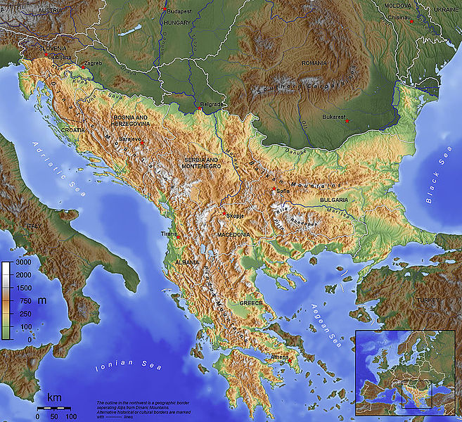
English: The topography of the Balkan Peninsula, as defined by the Danube-Sava-Kupa line. |
||||||||||
| Datum | 2006, before Serbia and Montenegro was split into two separate states. | ||||||||||
| Quelle | Eigenes Werk | ||||||||||
| Urheber | Captain Blood~commonswiki | ||||||||||
| Genehmigung (Weiternutzung dieser Datei) |
|
||||||||||
| Andere Versionen |
|

Dateiversionen
Klicke auf einen Zeitpunkt, um diese Version zu laden.
| Version vom | Vorschaubild | Maße | Benutzer | Kommentar | |
|---|---|---|---|---|---|
| aktuell | 11:15, 14. Nov. 2015 | | 840 × 767 (638 KB) | SilentResident | Corrected mistake in which the Aegean and Ionian islands were marked as part of the Balkan topography. |
| 23:53, 1. Feb. 2012 |  | 1.384 × 1.264 (726 KB) | Ras67 | losslessly cropped with Jpegcrop | |
| 23:52, 1. Feb. 2012 |  | 1.384 × 1.264 (726 KB) | Ras67 | losslessly cropped with Jpegcrop | |
| 19:34, 14. Apr. 2006 |  | 1.400 × 1.278 (748 KB) | Captain Blood~commonswiki | labels | |
| 19:22, 2. Apr. 2006 |  | 1.400 × 1.278 (748 KB) | Captain Blood~commonswiki | Una border | |
| 21:38, 1. Apr. 2006 |  | 1.400 × 1.278 (741 KB) | Captain Blood~commonswiki | {{Bild-GFDL-GMT}} |
Dateiverwendung
Keine Seiten verwenden diese Datei.
Globale Dateiverwendung
Die nachfolgenden anderen Wikis verwenden diese Datei:
- Verwendung auf af.wikipedia.org
- Verwendung auf ang.wikipedia.org
- Verwendung auf an.wikipedia.org
- Verwendung auf ar.wikipedia.org
- Verwendung auf arz.wikipedia.org
- Verwendung auf ast.wikipedia.org
- Verwendung auf be-tarask.wikipedia.org
- Verwendung auf bg.wikipedia.org
- Verwendung auf bn.wikipedia.org
- Verwendung auf bs.wikipedia.org
- Verwendung auf ca.wikipedia.org
- Verwendung auf ckb.wikipedia.org
Weitere globale Verwendungen dieser Datei anschauen.