Datei:England AONBs map.svg
Zur Navigation springen
Zur Suche springen

Größe der PNG-Vorschau dieser SVG-Datei: 494 × 599 Pixel. Weitere aus SVG automatisch erzeugte PNG-Grafiken in verschiedenen Auflösungen: 198 × 240 Pixel | 396 × 480 Pixel | 633 × 768 Pixel | 844 × 1.024 Pixel | 1.688 × 2.048 Pixel | 512 × 621 Pixel
Originaldatei (SVG-Datei, Basisgröße: 512 × 621 Pixel, Dateigröße: 1,92 MB)
![]()
Diese Datei und die Informationen unter dem roten Trennstrich werden aus dem zentralen Medienarchiv Wikimedia Commons eingebunden.
![]()
Beschreibung
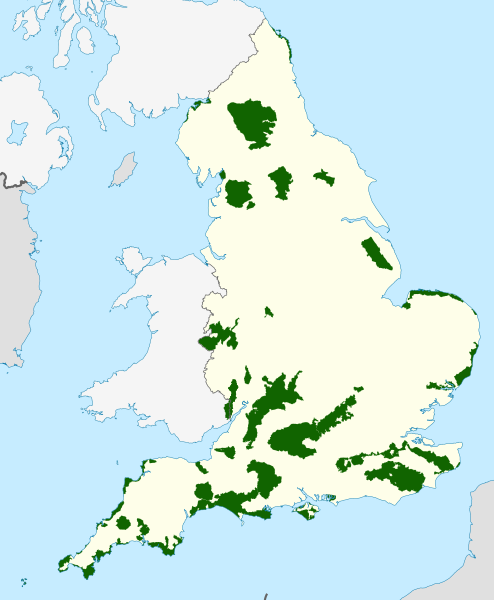
| Beschreibung | Map showing all of the Areas of Outstanding Natural Beauty of England, in the United Kingdom. |
| Datum | |
| Quelle |
Ordnance Survey OSOpenData Boundary-Line:
Natural England UK Government (Defra)–Natural England
|
| Urheber |
Dank · Jay, using Ordnance Survey, and Natural England data. Diese Datei enthält Elemente, die von folgender Datei entnommen oder adaptiert wurden: Diese Datei enthält Elemente, die von folgender Datei entnommen oder adaptiert wurden: Diese Datei enthält Elemente, die von folgender Datei entnommen oder adaptiert wurden: |
| Genehmigung (Weiternutzung dieser Datei) |
Diese Datei ist unter der Creative-Commons-Lizenz „Namensnennung – Weitergabe unter gleichen Bedingungen 3.0 nicht portiert“ lizenziert. Namensnennung: © Natural England copyright 2021. Contains Ordnance Survey data © Crown copyright and database right 2021
|
| Andere Versionen | Wales AONBs; Northern Ireland AONBs; UK AONBs |
Dateiversionen
Klicke auf einen Zeitpunkt, um diese Version zu laden.
| Version vom | Vorschaubild | Maße | Benutzer | Kommentar | |
|---|---|---|---|---|---|
| aktuell | 19:22, 13. Okt. 2021 | | 512 × 621 (1,92 MB) | DankJae | Added the Wye Valley parts in Wales |
| 19:15, 13. Okt. 2021 |  | 512 × 621 (1,91 MB) | DankJae | Uploaded own work with UploadWizard |
Dateiverwendung
Keine Seiten verwenden diese Datei.
Globale Dateiverwendung
Die nachfolgenden anderen Wikis verwenden diese Datei:
- Verwendung auf en.wikipedia.org
- Cornwall
- Cotswolds
- Suffolk & Essex Coast & Heaths National Landscape
- Area of Outstanding Natural Beauty
- Cannock Chase
- Quantock Hills
- Mendip Hills
- Chiltern Hills
- Forest of Bowland
- Isle of Wight National Landscape
- Malvern Hills
- North Wessex Downs
- Lincolnshire Wolds
- North Pennines
- Kent Downs
- Blackdown Hills National Landscape
- Shropshire Hills National Landscape
- High Weald National Landscape
- Chichester Harbour
- Howardian Hills
- Surrey Hills National Landscape
- Nidderdale National Landscape
- Lindfield, West Sussex
- Dedham Vale National Landscape
- Arnside and Silverdale National Landscape
- Wye Valley
- North Devon Coast
- East Devon National Landscape
- Tamar Valley National Landscape
- Template:AONBs in England
- South Devon National Landscape
- Solway Coast
- Northumberland Coast National Landscape
- Cranborne Chase and West Wiltshire Downs
- Norfolk Coast National Landscape
- East Hampshire AONB
- South Hampshire Coast
- Isles of Scilly
- Sussex Downs AONB
- User:Karmstro/Sandbox
- Cornwall National Landscape