Datei:General Government for the occupied Polish territories (1941).png
Zur Navigation springen
Zur Suche springen

Größe dieser Vorschau: 605 × 600 Pixel. Weitere Auflösungen: 242 × 240 Pixel | 484 × 480 Pixel | 774 × 768 Pixel | 1.033 × 1.024 Pixel | 2.299 × 2.280 Pixel
Originaldatei (2.299 × 2.280 Pixel, Dateigröße: 543 KB, MIME-Typ: image/png)
![]()
Diese Datei und die Informationen unter dem roten Trennstrich werden aus dem zentralen Medienarchiv Wikimedia Commons eingebunden.
![]()
.png?uselang=de)
Beschreibung
| Beschreibung |
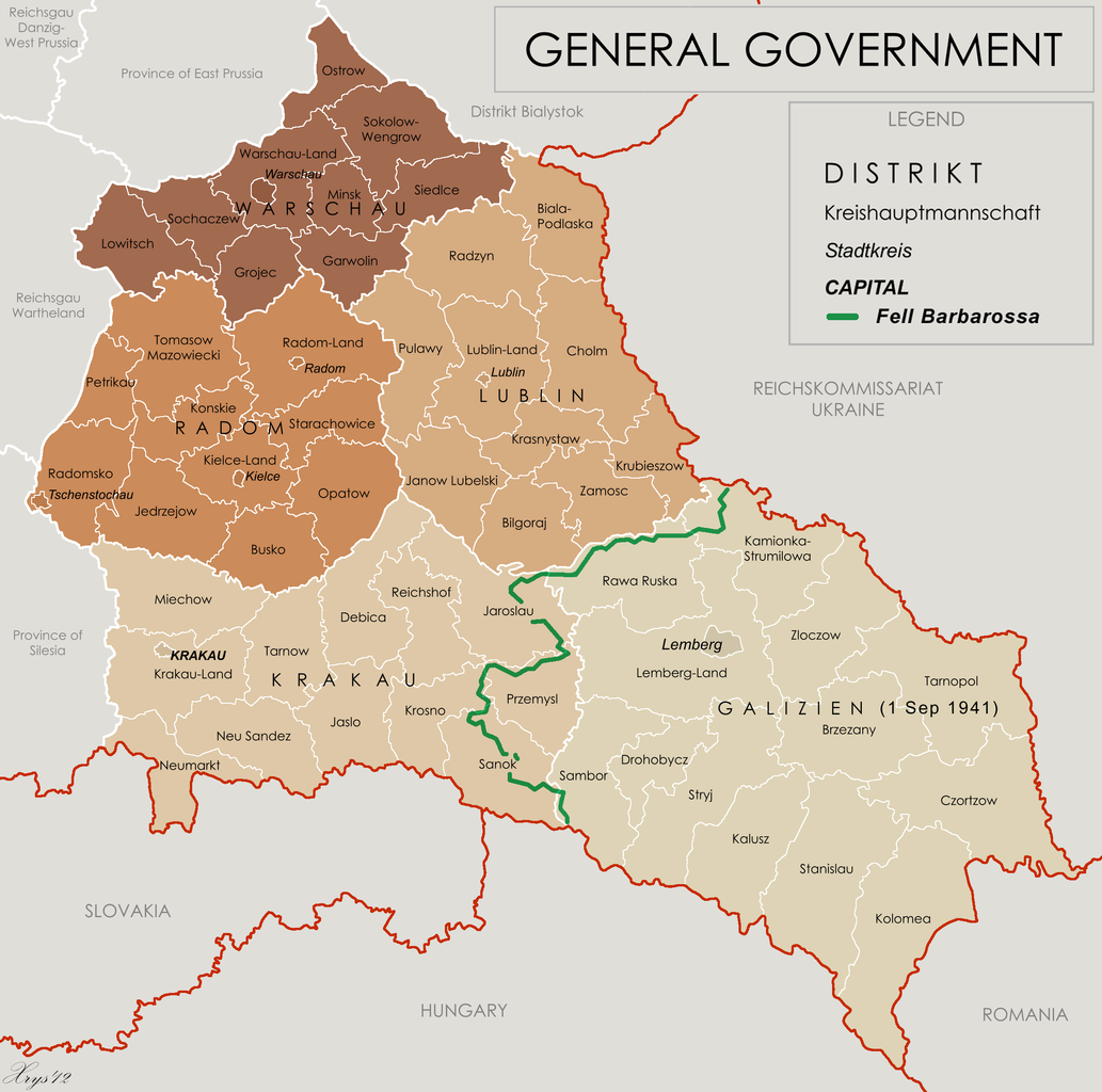
English: Map of the administrative areas of the General Government |
| Datum | |
| Quelle |
Eigenes Werk by XrysD, edited by Poeticbent with superimposed German-Soviet border before Operation Barbarossa. Sources at: File:Generalne gubernatorstwo 1945.png and File:Western portions of the Ukrainian SSR 1940.jpg A published source with the same information is Musial, Bogdan (2000) (Deutsch) Deutsche Zivilverwaltung und Judenverfolgung im Generalgouvernement: eine Fallstudie zum Distrikt Lublin 1939-1944, Otto Harrassowitz Verlag, S. 424 ISBN: 978-3-447-05063-0. |
| Urheber | XrysD and User:Poeticbent (the 1941 demarkation line and legend) |
| Andere Versionen |
File:Generalgouvernement fur die besetzten polnischen gebiete.png |
Lizenz
Diese Datei ist unter der Creative-Commons-Lizenz „Namensnennung – Weitergabe unter gleichen Bedingungen 3.0 nicht portiert“ lizenziert.
- Dieses Werk darf von dir
- verbreitet werden – vervielfältigt, verbreitet und öffentlich zugänglich gemacht werden
- neu zusammengestellt werden – abgewandelt und bearbeitet werden
- Zu den folgenden Bedingungen:
- Namensnennung – Du musst angemessene Urheber- und Rechteangaben machen, einen Link zur Lizenz beifügen und angeben, ob Änderungen vorgenommen wurden. Diese Angaben dürfen in jeder angemessenen Art und Weise gemacht werden, allerdings nicht so, dass der Eindruck entsteht, der Lizenzgeber unterstütze gerade dich oder deine Nutzung besonders.
- Weitergabe unter gleichen Bedingungen – Wenn du das Material wiedermischst, transformierst oder darauf aufbaust, musst du deine Beiträge unter der gleichen oder einer kompatiblen Lizenz wie das Original verbreiten.
Dateiversionen
Klicke auf einen Zeitpunkt, um diese Version zu laden.
| Version vom | Vorschaubild | Maße | Benutzer | Kommentar | |
|---|---|---|---|---|---|
| aktuell | 17:33, 8. Mai 2014 | | 2.299 × 2.280 (543 KB) | Poeticbent | legend |
| 18:48, 18. Mär. 2014 |  | 2.299 × 2.280 (453 KB) | Poeticbent | =={{int:filedesc}}== {{Information |description={{en|1=Map of the administrative areas of the General Government}} |date=2012-05-26 |source={{own}} by {{u|XrysD}}, edited by {{u|Poeticbent}} with superimposed German-Soviet border before Operation Barba... |
Dateiverwendung
Keine Seiten verwenden diese Datei.
Globale Dateiverwendung
Die nachfolgenden anderen Wikis verwenden diese Datei:
- Verwendung auf ar.wikipedia.org
- Verwendung auf azb.wikipedia.org
- Verwendung auf en.wikipedia.org
- Verwendung auf es.wikipedia.org
- Verwendung auf fr.wikipedia.org
- Verwendung auf it.wikipedia.org
- Verwendung auf no.wikipedia.org
- Verwendung auf pl.wikipedia.org
- Verwendung auf pt.wikipedia.org
- Verwendung auf ru.wikipedia.org
- Verwendung auf www.wikidata.org
- Verwendung auf zh.wikipedia.org
.png)