Datei:Island of Ireland location map Clare.svg
Zur Navigation springen
Zur Suche springen

Größe der PNG-Vorschau dieser SVG-Datei: 481 × 599 Pixel. Weitere aus SVG automatisch erzeugte PNG-Grafiken in verschiedenen Auflösungen: 192 × 240 Pixel | 385 × 480 Pixel | 616 × 768 Pixel | 822 × 1.024 Pixel | 1.643 × 2.048 Pixel | 1.450 × 1.807 Pixel
Originaldatei (SVG-Datei, Basisgröße: 1.450 × 1.807 Pixel, Dateigröße: 642 KB)
![]()
Diese Datei und die Informationen unter dem roten Trennstrich werden aus dem zentralen Medienarchiv Wikimedia Commons eingebunden.
![]()
| Beschreibung |
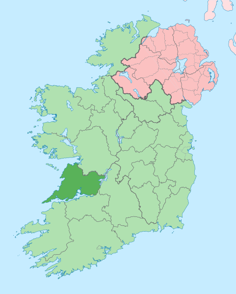
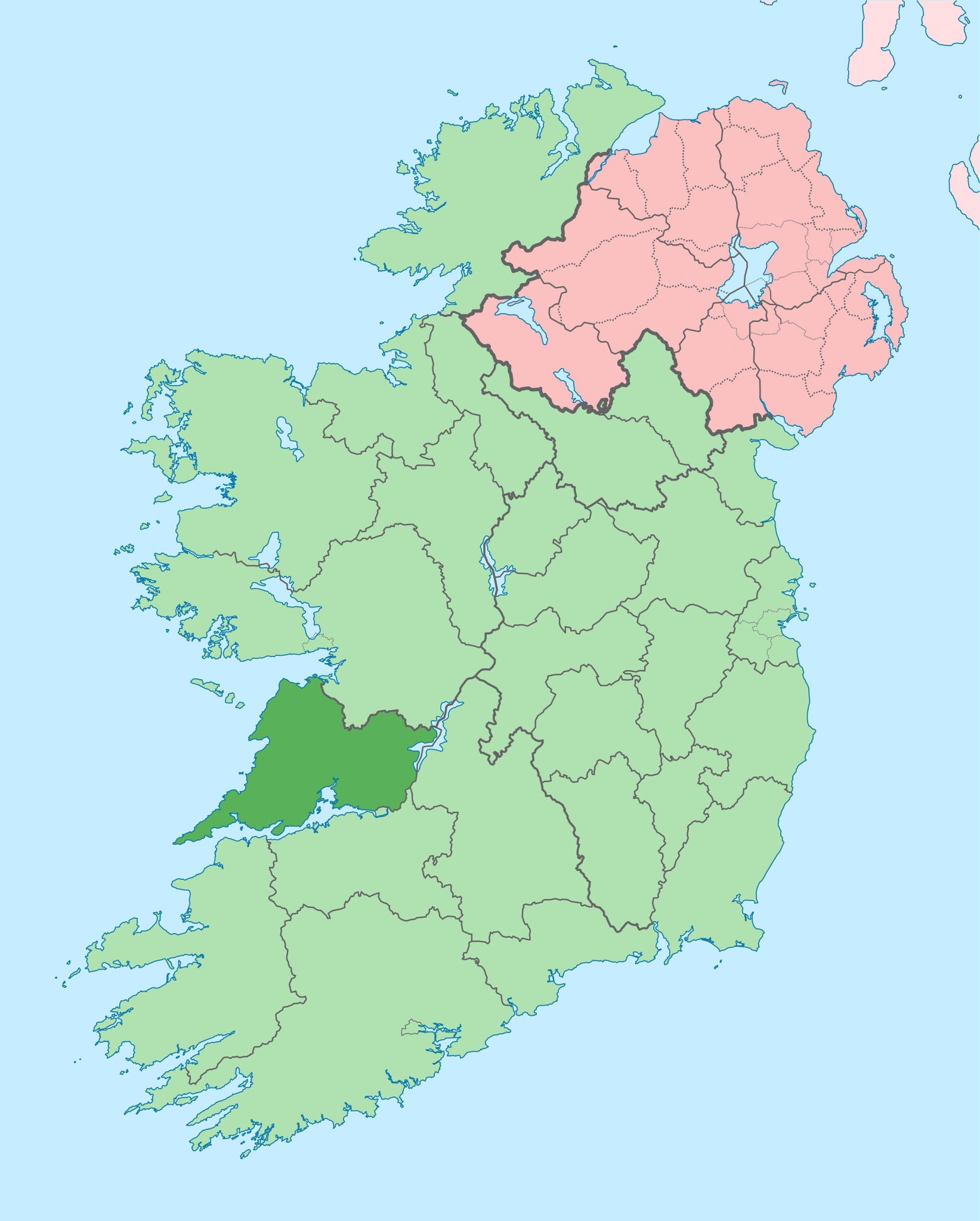
English: The island of Ireland, showing international border between Ireland and Northern Ireland, traditional provinces, traditional counties, and local authority areas in Ireland and Northern Ireland. |
| Datum | (UTC) |
| Quelle | |
| Urheber |
|
| Dieses Bild wurde digital nachbearbeitet. Folgende Änderungen wurden vorgenommen: Coloured in regions with county of article highlighted. Das Originalbild kann hier eingesehen werden: Island of Ireland location map.svg:
|
Ich, der Urheber dieses Werkes, veröffentliche es unter der folgenden Lizenz:
Diese Datei ist unter der Creative-Commons-Lizenz „Namensnennung – Weitergabe unter gleichen Bedingungen 3.0 nicht portiert“ lizenziert.
- Dieses Werk darf von dir
- verbreitet werden – vervielfältigt, verbreitet und öffentlich zugänglich gemacht werden
- neu zusammengestellt werden – abgewandelt und bearbeitet werden
- Zu den folgenden Bedingungen:
- Namensnennung – Du musst angemessene Urheber- und Rechteangaben machen, einen Link zur Lizenz beifügen und angeben, ob Änderungen vorgenommen wurden. Diese Angaben dürfen in jeder angemessenen Art und Weise gemacht werden, allerdings nicht so, dass der Eindruck entsteht, der Lizenzgeber unterstütze gerade dich oder deine Nutzung besonders.
- Weitergabe unter gleichen Bedingungen – Wenn du das Material wiedermischst, transformierst oder darauf aufbaust, musst du deine Beiträge unter der gleichen oder einer kompatiblen Lizenz wie das Original verbreiten.
Ursprüngliches Datei-Logbuch
This image is a derivative work of the following images:
- File:Island_of_Ireland_location_map.svg licensed with Cc-by-sa-3.0
- 2010-03-06T20:43:33Z Rannpháirtí anaithnid 1450x1807 (679207 Bytes) Fix incorrectly coloured isands.
- 2010-03-03T22:19:29Z Rannpháirtí anaithnid 1450x1807 (679744 Bytes) {{Information |Description={{de|Positionskarte von [[:de:Irland|Irland]]}} Quadratische Plattkarte, N-S-Streckung 170 %. Geographische Begrenzung der Karte: * N: 55.6° N * S: 51.2° N * W: 11.0° W * O: 5.0° W {{en|Location
Hochgeladen mit derivativeFX
Dateiversionen
Klicke auf einen Zeitpunkt, um diese Version zu laden.
| Version vom | Vorschaubild | Maße | Benutzer | Kommentar | |
|---|---|---|---|---|---|
| aktuell | 16:05, 28. Jun. 2020 | | 1.450 × 1.807 (642 KB) | Chipmunkdavis | Colouring in Aughinish |
| 17:54, 26. Jun. 2020 |  | 1.450 × 1.807 (642 KB) | Chipmunkdavis | Rmv stray number in code | |
| 17:26, 26. Jun. 2020 |  | 1.450 × 1.807 (642 KB) | Chipmunkdavis | Merging Tipperary and Waterford shapes | |
| 14:55, 26. Jun. 2020 |  | 1.450 × 1.807 (643 KB) | Chipmunkdavis | Removing Limerick City | |
| 18:21, 25. Jun. 2020 |  | 1.450 × 1.807 (643 KB) | Chipmunkdavis | Per the Local Government Reform Act 2014, removing the Tipperary border and the Waterford City border. | |
| 18:10, 25. Jun. 2020 |  | 1.450 × 1.807 (646 KB) | Chipmunkdavis | Removing lots of stray objects. Fixing location of Clare and one island slightly. | |
| 17:45, 25. Jun. 2020 |  | 1.450 × 1.807 (695 KB) | Chipmunkdavis | Colour islands in, place all islands and borders in groups, remove some blank and redundant shapes | |
| 02:41, 19. Jul. 2010 |  | 1.450 × 1.807 (815 KB) | Mabuska | {{Information |Description={{en|The island of Ireland, showing international border between Northern Ireland and Republic of Ireland, traditional provinces, traditional counties, and local authority areas in the Republic of Ireland and Northern Ireland.}} |
Dateiverwendung
Keine Seiten verwenden diese Datei.
Globale Dateiverwendung
Die nachfolgenden anderen Wikis verwenden diese Datei:
- Verwendung auf ar.wikipedia.org
- Verwendung auf ast.wikipedia.org
- Verwendung auf bg.wikipedia.org
- Verwendung auf ca.wikipedia.org
- Verwendung auf ceb.wikipedia.org
- Verwendung auf cs.wikipedia.org
- Verwendung auf en.wikipedia.org
- County Clare
- Inagh
- Ennis
- List of Ireland-related topics
- Shannon, County Clare
- Lissycasey
- Shannon Free Zone
- Lisdoonvarna
- Cratloe
- Doolin
- Kilfenora
- Ballyvaughan
- Carran
- Kilkee
- Kilrush
- Clarecastle
- Ennistymon
- Killaloe, County Clare
- Lahinch
- Liscannor
- Mountshannon
- Newmarket-on-Fergus
- O'Brien's Bridge
- Spanish Point, County Clare
- Aughinish, County Clare
Weitere globale Verwendungen dieser Datei anschauen.